Parang La Trek
TREK DIFFICULTY
Difficult
TREK DURATION
9 Days
HIGHEST ALTITUDE
18,300 ft
GROUP SIZE
5-6
TREK DISTANCE
128 km
BASECAMP
Ladakh
BEST TIME
mid-July to August
PICKUP POINT
Ladakh
Parang La Trek Overview
Parang La Trek is a mesmerizing and thrilling trek. This is a very challenging trans-Himalayan. You start your trek from the cold desert of Spiti and walk to the beautiful land of Ladakh. The Parang La is a high-altitude pass that connects Spiti to Ladakh.
The trek is very difficult but has some of the most beautiful landscapes. This journey is a pure adventure and an experience of raw nature. You will walk on the rugged terrain in a very remote area. Your Parang La Trek will start from Kibber. This is a beautiful high-altitude inhabitant village. You will start ascending the rugged mountains alongside the Pare Chu River.
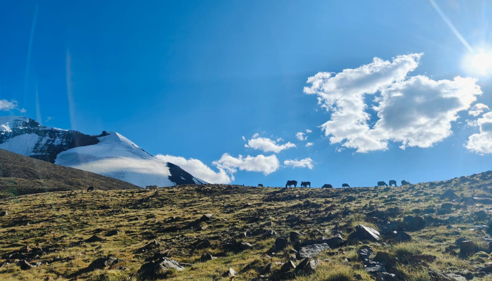
The landscapes in the trek are unmatched. You will start from rugged mountains and then walk through meadows and glacial fields. The most challenging part of the trek is crossing Parang La. You will walk on the moraines and icy stretches. But the views from Parang La are outstanding.
The sunrise and sunset on the big snow-capped mountains are majestic. You will be surprised with the beauty everyday. The most beautiful landscape of the trek is the Tso Moriri Lake. This beautiful lake is located at 15075 feet. The turquoise water surrounded by big mountains feels majestic. The Parang La trek gives you a true sense of achievement.
Day 1 : Drive from Manali to Chandratal
- Drive Distance: 111 km | Drive Duration: 3.5 hours
- Accommodation: Camping | Meals: Lunch + Snacks + Dinner
Day 2 : Drive from Chandratal to Kaza
- Drive Distance: 97 km | Drive Duration: 3 hours
- Accommodation: Homestay/camping | Meals: Breakfast + Lunch + Snacks + Dinner
Day 3 : Drive from Kaza to Dhum La
- Drive Distance: 18 km | Drive duration: 1 hour
- Altitude: 4270 M
Day 4 : Rest
Day 5 : Dumla to Thaltak Meadow
- Trek distance: 8 km | Altitude gain: 4270 M to 4693 M
- Accommodation: Camping
- Meals: Breakfast + Lunch + Snacks + Dinner
Day 6 : Thaltak Meadow to Jagtha | Jagtha to Bongrojen
- Trek Distance: 12 KM | Altitude Gain: 4693 M to 5100 M
- Accommodation: Camping
- Meals: Breakfast + Lunch + Snacks + Dinner
Day 7 : Bongrojen to Parang La (18290 feet) | Parang La to Dak Karzong
- Trek Distance: 14 KM | Altitude Loss and Gain: 5100 M to 5580 M to 4850 M
- Accommodation: Camping
- Meals: Breakfast + Lunch + Snacks + Dinner
Day 8 : Dak Karzong to Datang Yongma
- Trek Distance: 21.2 Km| Altitude Loss: 4850 M - 4704 M
- Accommodation: Camping
- Meals: Breakfast + Lunch + Snacks + Dinner
Day 9 : Datang Yongma to Chumik Shilde
- Trek Distance: 24.2 Km | Altitude Loss: 4704 M - 4595 M
- Accommodation: Camping
- Meals: Breakfast + Lunch + Snacks + Dinner
Day 10 : Chumik Shilde to Tso Moriri
- Trek Distance: 10.4 Km | Altitude loss: 4595 M - 4529 M
- Accommodation: Camping
- Meals: Breakfast + Lunch + Snacks + Dinner
Day 11 : Tso Moriri to Korzok (14850 feet/ 6-7 hours)
- Trek Distance: 22.7 km| Altitude: 4579 M
- Accommodation: Camping
- Meals: Breakfast + Lunch + Snacks + Dinner
Day 12 : Drive from Korzok to Leh
- Drive Distance: 211 km
Parang La Trek is not a journey but an odyssey to adventure and beauty. Plan your Parang La Trek with us and make it a lifetime moment. The landscapes are something that you can’t find on other Himalayan Treks. Parang La Trek is beautiful yet challenging.
There is a lot to prepare for this trek. Book your trek with us and forget all the worries. Our company will plan out everything for you. We are a team of experts who are there for you on every step. Our guides are very experienced and will take care of you throughout the trek.
Himalaya Shelter (HS) offers customized trekking services for Parang La. You can plan your trek on your dates and we will make all the arrangements. We can customize your stays, campsites, meals, and everything. We are open for small groups to provide a better trekking experience. Book your Parang La Trek with Himalaya Shelter and create memories that will last forever with you.
Parang La has been a crucial Pass of Ladakh for centuries. This has deep connections to ancient trade and cultural exchange. The Parang La is a vital trade route between the Spiti Valley and Ladakh. This also has trade connections with Tibet. This trail has always been famous among traders, nomads, and pilgrims.
They used to follow this trail for exchanging goods and cultural traditions. In the past, the Spiti region was like a cut-off from the mainland. The terrain was difficult, and routes usually remain closed in the winter. But Spiti was always connected to Ladakh and other Tibetan regions via Parang La. These regions have similar cultural routes.
Today, Parang La has become a famous trekking route. People from around the world trek to Parang La to feel the determination and raw beauty. Walking beside the Pare Chu river is also a great feeling. This river originates from Himachal and flows to Tibet and then re-enters Himachal.
Trekkers do the Parang La Trek for passion. But it has always been a survival route for the locals of Spiti. This same route has been walked by many traders, nomads, and monks for centuries.
Crossing Parang La:
- Parang La is a divine beauty of nature. You walk for 3-4 days and then reach Parang La. One side is Spiti and another side is Ladakh. The Parang La lies between the two beautiful locations. All the snow-capped mountains look breathtaking from this pass. Crossing Parang La is difficult but is always pleasurable.
Tso Moriri Lake:
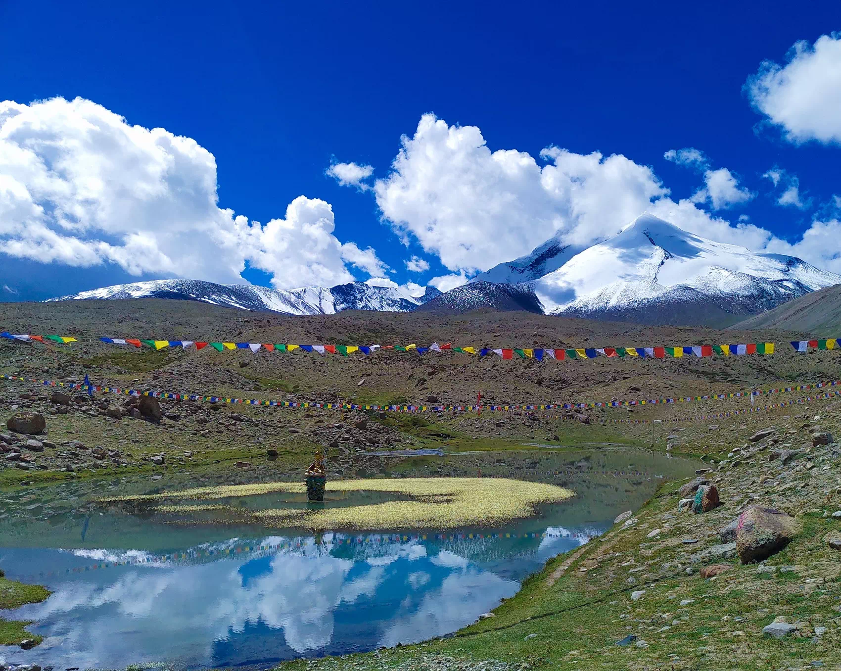
- The Tso Moriri Lake in Ladakh is located at an altitude of 15075 m. This lake fills the color in the brown landscape. Everywhere you look is brown, and the lake between the big mountains is turquoise. Trekkers spend hours and hours just sitting and captivating the beauty of the lake.
Challenging Terrain:
- The Parang La Trek is a very difficult trek. The trail is very challenging and has big, rugged mountains. The altitude is already very high from where you start, and then ascending to the pass is very challenging. The trail is very tough yet rewarding.
Cultural Experience:
- There are very few villages on the trek. You start the trek from Kibber. This village is in a remote location and the culture is very different. You can see centuries-old monasteries and stone houses. The locals are very heartwarming and easy-going. You may also witness the nomadic lifestyle of the high-altitude Himalayan region.
The Parang La is probably one of the most difficult treks in India. The altitude is very high and the terrain is very rough. You should have a good high-altitude trekking experience for the Parang La Trek. This trek is exquisite yet challenging.
High-Altitude Trek
- You will start your Parang La Trek from Kibber. This is a high-altitude village. The altitude of this village is over 4000 m. This height means risk of AMS. Now, from here, you ascend to Parang La, which is over 5000 m. The oxygen level reduces, and you can have AMS problems.
Difficult Terrian
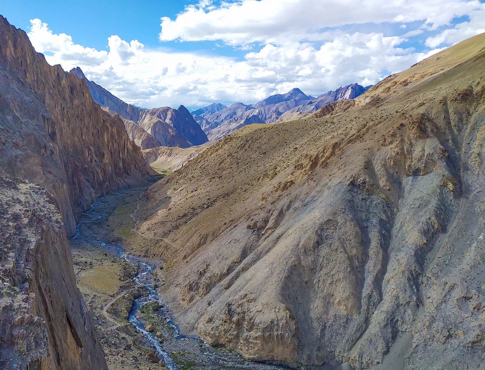
- The trail to Parang La is very challenging. The trail has rocky ridges and moraines. You will cross rivers and walk on rocky ridges. After crossing Parang La, you will walk on the glacier. These sections are very difficult and need good trekking expertise.
Long Trekking Hours
- The Parang La Trek is about 130 km long. You will cover this distance in 9-10 days. The terrain is already difficult, and you have to walk for about 8-10 hours daily. This much walking needs good physical stamina and endurance. The rest days are rare, and the trek is very long.
Weather Conditions
- Parang La is located in a rain shadow area. Unlike other Himalayan treks, rain is not a big problem here. The main difficulty is the cold. It is a cold desert where the temperature can drop to sub-zero temperatures. The temperature can drop to -15℃ at higher camps. The daytime can be harsh, as it can be very sunny. You might get sudden snow or a windstorm on the trek.
Parang La is located in a high-altitude cold desert zone. It remains low all around the year. You can trek to Parang La in only a few months of the year. The trails and roads remain closed in winter due to heavy snowfall.
Parang La Trek In May And June
- This is not a good time to plan your Parang La trek. The Parang La is buried under the snow. The trails remain blocked, and you might miss the correct route sometimes. The snow starts melting and the water level increases in the river. Crossing the river can be very dangerous.
Parang La Trek From Mid-July To Early September
- This is the best and safest time to plan the Parang La trek is from mid-July to early-September. The trails are open, and you will see snow only in the very high areas. The temperature also remains good. Nights can be very chilly, but the days feel warm. Clear skies with beautiful views. The Tso Moriri lake looks majestic, and you can also witness rare birds.
Parang La Trek From Late-September To October
- This time window can be very risky. Snowfall starts, and the temperature can drop to -15℃. Camping at this temperature can be very difficult. Strong icy winds can make the trek more challenging.
Parang La Trek From November To April
- You cannot trek to Parang La in winter. The roads are fully blocked. You can’t enter from any side, neither Spirit nor Ladakh. The temperature can drop to -30℃ at night. This area is very remote and also prone to avalanches.
You will start your Parang La Trek from Kibber. This is a very remote village in Spiti. This village is very far from all major cities. Reaching Kibber also takes too much time. Reach Kibber and spend 1-2 days there for acclimatization.
Kibber By Road
- You can start your journey to Kibber from Manali. Many direct bus services are available from Delhi and Chandigarh. Take an overnight bus to reach Manali. Now look for a bus or shared taxi to Kaza. The distance is 200 km and will take about 10 hours. Now, from Kaza, take a local taxi to Kibber.
Kibber By Train
- You can take a train to Chandigarh or Pathankot. These cities have good railway connections to all major cities. Now, from there, take a bus to Manali. You can find both government and private bus services. Some AC and Volvo bus services are also available. Reach Manali and take a bus to Kaza. Now take a shared taxi or jeep to Kibber.
Kibber By Air
- Look for direct flights to Bhuntar Airport (Kull-Manali Airport). This airport is about 50 km from Manali. The direct flights to Manali are limited. You can look for flights to Chandigarh or Delhi. Now, from there, take an overnight bus to Manali. Reach Manali and cover the remaining journey by road.
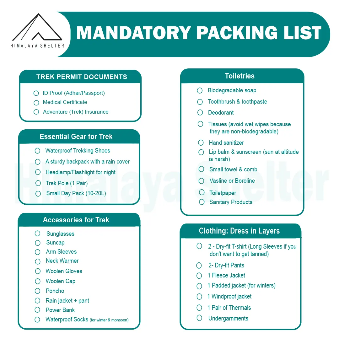
Mandatory Backpacking List for Aancha Top Trek
Clothing and Backpack
Get a good backpack (50 L) with a rain cover. Look for a bag that can provide you good back support. Pack 4 quick-dry t-shirts and 2 trekking pants. Get a pair of thermals (upper and lower) for night. Pack a fleece jacket or woolen sweater as a mid-layer. Get a waterproof wind breaker for sudden rain and chilly winds. For winter trekking, get a good down jacket. Now pack a woolen beanie and a balaclava. Get two pairs of gloves (woolen and waterproof). You should also pack a suncap for the daytime.
Footwear
You should look for good quality trekking shoes. Your shoes must be waterproof and provide good ankle support. Do not wear a new pair of shoes on the trek. Your feet must be familiar with the shoes. Now pack 4 pairs of trekking socks and 2 pairs of woolen socks. Pack a pair of comfortable slippers or sandals for the campsite.
Personal Care
For personal care items, start packing with your toiletries. Get a small zipper pouch and pack all the toiletries. Now look for a quick-dry towel and a toilet roll. You should also pack hand sanitizer and moisturizer. Pack a sunscreen that can protect your face from sunburn. You can also pack some snacks for the trek.
Physical Fitness Preparation for Trek:
To overcome the difficulty level of trekking, it requires strong cardiovascular endurance, muscular strength, and overall physical fitness. Incorporate these exercises into your routine to increase strength, stability, and stamina, which will help you tackle difficult terrain sections of the trail at high altitudes.
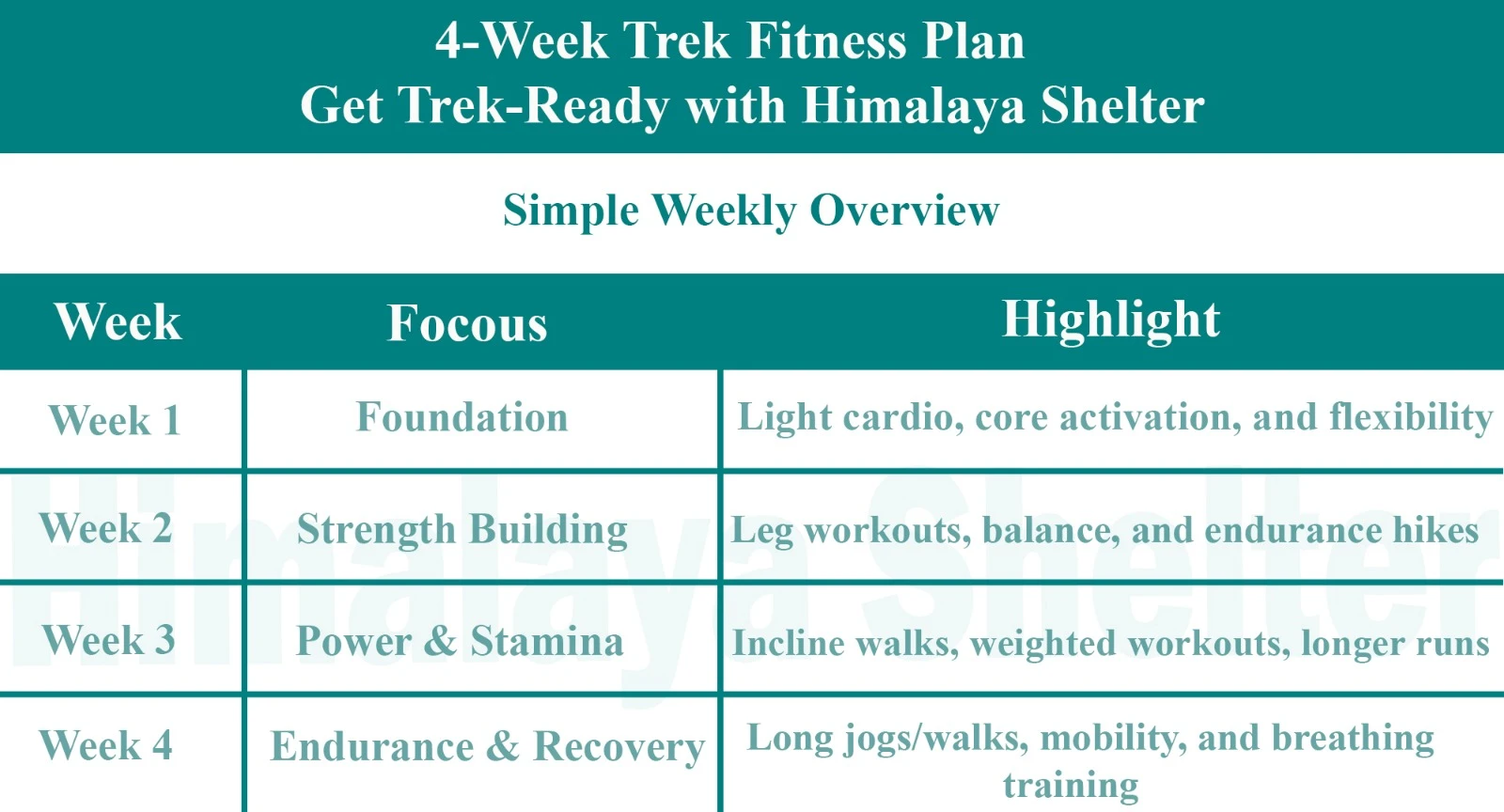
Overview

Foundation
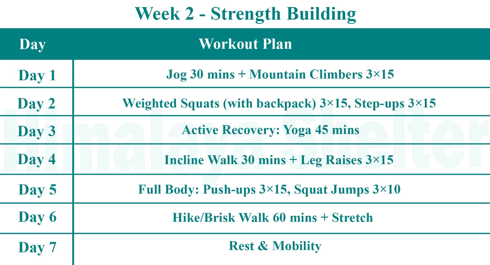
Strength Building

Power & Stamina
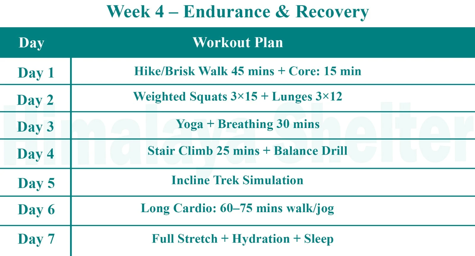
Endurance & Recovery
Day 1: Drive from Manali to Chandratal
Drive Distance: 111 km | Drive Duration: 3.5 hours
Accommodation: Camping | Meals: Lunch + Snacks + Dinner
Day 2: Drive from Chandratal to Kaza
Drive Distance: 97 km | Drive Duration: 3 hours
Accommodation: Homestay/camping | Meals: Breakfast + Lunch + Snacks + Dinner
Day 3: Drive from Kaza to Dhum La
Drive Distance: 18 km | Drive duration: 1 hour
Altitude: 4270 M
- Drive from Kaza to Ki. Enjoy the scenic drive along the Spiti River to Ki The road is relatively well-maintained but can be narrow and winding in some places. After reaching Kibber start your short hike towards Dumbla, When you reach to the campsite stay overnight there.
Day 4: Rest
Day 5: Dumla to Thaltak Meadow
Trek distance: 8 km | Altitude gain: 4270 M to 4693 M
Accommodation: Camping
Meals: Breakfast + Lunch + Snacks + Dinner
- Start your trek towards Thaltak Meadow. The trek is expected to take around 3-4 hours, but it may vary depending on your pace and the terrain.As you ascend, be prepared for breathtaking views of the surrounding mountains and valleys. Take your time to appreciate the natural beauty.
- Once you arrive at Thaltak Meadow campsite stay overnight there.
Day 6: Thaltak Meadow to Jagtha | Jagtha to Bongrojen
Trek Distance: 12 KM | Altitude Gain: 4693 M to 5100 M
Accommodation: Camping
Meals: Breakfast + Lunch + Snacks + Dinner
- Begin your trek from Thaltak Meadow to Jagtha. This portion of the trail may involve some steep ascents and descents. As you trek, take in the breathtaking views of the surrounding mountains and valleys.
- When you arrive at Jagtha, take a well-deserved break. Resume your trek from Jagtha to Bongrojen. This part of the journey may involve challenging terrain,
- As you reach Bongrojen. you’ll likely be at a higher altitude, so take it easy. Bongrojen is known for its pristine beauty and panoramic views.
Day 7: Bongrojen to Parang La (18290 feet) | Parang La to Dak Karzong
Trek Distance: 14 KM | Altitude Loss and Gain: 5100 M to 5580 M to 4850 M
Accommodation: Camping
Meals: Breakfast + Lunch + Snacks + Dinner
- Begin your day with an early start to make the most of daylight. The journey to Parang La will be arduous, with steep ascents and descents. when you reached Parang La! Take a moment to revel in the accomplishment and enjoy the panoramic views from the pass.
- Begin your descent from Parang La toward Dak Karzong. This part of the trek will involve a gradual descent and may be less strenuous than the ascent to the pass. As you reach Dak Karzong, stay overnight there
Day 8: Dak Karzong to Datang Yongma
Trek Distance: 21.2 Km| Altitude Loss: 4850 M - 4704 M
Accommodation: Camping
Meals: Breakfast + Lunch + Snacks + Dinner
- Begin your trek from Dak Karzong to Datang Yongma. This portion of the trail may involve some ascents and descents. take in the breathtaking views of the surrounding mountains and valleys.
- When you arrive at Datang Yongma campsite stay overnight ther
Day 9: Datang Yongma to Chumik Shilde
Trek Distance: 24.2 Km | Altitude Loss: 4704 M - 4595 M
Accommodation: Camping
Meals: Breakfast + Lunch + Snacks + Dinner
- Embark on your trek from Datang Yongma to Chumik Shilde. Along the way, take in the awe-inspiring views of the surrounding mountains and valleys.
- When you arrive at Chumik Shilde, take a well-deserved break. Chumik Shilde is at a high altitude, so ensure you acclimatize properly.
Day 10: Chumik Shilde to Tso Moriri
Trek Distance: 10.4 Km | Altitude loss: 4595 M - 4529 M
Accommodation: Camping
Meals: Breakfast + Lunch + Snacks + Dinner
- Embark on your trek from Chumik Shilde to Tso Moriri. Along the way, take in the awe-inspiring views of the surrounding mountains and valleys When you arrive at Tso Moriri, take a well-deserved break. and stay overnight there.
Day 11: Tso Moriri to Korzok (14850 feet/ 6-7 hours)
Trek Distance: 22.7 km| Altitude: 4579 M
Accommodation: Camping
Meals: Breakfast + Lunch + Snacks + Dinner
- Embark on your trek from Tso Moriri to Korzok. Along the way, take in the breathtaking views of the surrounding mountains and the shimmering blue waters of Tso Moriri. When you arrive at Korzok, take a well-deserved break. Korzok is at a high altitude, so ensure you acclimatize properly.
Day 12: Drive from Korzok to Leh
Drive Distance: 211 km
- Travel by road from Korzok to Leh to end the journey at Parang La.
- Fly to Delhi to tour the city or travel to Srinagar or Manali.
Our treks are specially designed by the experienced team at Himalaya Shelter, taking you on an adventure of a lifetime all while making you connect not only with the bountiful nature but also with yourself and with others on the trek with you creating wonderful memories which will last you a lifetime. All Himalaya Shelter treks are guided by experienced Trekkers having vast knowledge and experience of the region, providing with insightful information and stories pertaining to the region’s flora and fauna and the history of the region whilst the trek. It is safe to say that on successfully completing the trek, one will gain tremendous insight and experience along with lifetime memories.
Parang La Trek Inclusions
Transport Support
From Day 1 to Last Day
Accommodation
At Base Camp, stay at a local homestay or guest house for one night each, which will give you an insight into the authentic lifestyle of the locals.( INR 5000 per person extra for single sharing throughout the trek )
On Trek stay in a 2-person Vango Halo Pro/A-Shape tent, which is to be shared by two trekkers, built to withstand extreme weather conditions and at the same time making you comfortable after a hard day’s trek.
Camping Equipment
Specially designed sleeping bags that can withstand harsh weather conditions, foam mattresses. Other safety gear like microspikes, gaiters, an ice axe, and helmets will be provided.
Medical Kit
Our team will be equipped with an extensive medical kit, which our team is trained and experienced to use. Oxygen cylinders are used after they are thoroughly inspected throughout the Trek. Even campsites have large oxygen cylinders as backups.
Permission
Forest entry charges for Indian nationals (Additional charges will be applicable for international tourists)
Meals
Breakfast, packed lunch (on trek days), evening snacks, and dinner will be served. A hearty, delicious, and nutrition-filled Veg meals with egg preparation will be provided throughout the trek. (Jain and Vegan Food can also be arranged on prior notification.)There will be a dedicated Kitchen Tent along with a dining tent, which will have a dining table too.
Our Team
A highly experienced and AMC-certified Trek Leader who will help ensure that the entire trek goes smoothly and safely while navigating the challenging conditions during the trek, and is skilled enough to navigate any medical emergency that can arise during the trek.
Local and route Guides who are well-versed with the region and provide an in-depth insight into the local customs and knowledge of the flora and fauna endemic to the region. A dedicated Kitchen staff, which includes a Cook, a helper, and other support staff. There will also be porters and mules to carry common equipment.
Cloakroom
We have a cloakroom facility available for extra luggage. Every trekker is permitted to leave their luggage behind at no charge.
Parang La Trek Exclusions
Personal expenses
Like tips, personal medicines, phone calls etc.
Travel Expenses
Travel expenses from your hometown to the mentioned Pick-Up Point are not included in the trek fee.
From the scheduled pick-up spot to the base camp, we have our own fleet of vehicles like Bolero, Innova, Dezire, or Tempo Traveler (12-seater). This is be shared by trekkers for a pre-decided amount. All vehicles are non-AC.
Personal Equipment
Any personal gear like jackets, shoes, cutlery, or backpacks are not included in the trek fee. We recommend renting them from our Rental Store for an affordable fee. This can be pre-arranged to avoid last-minute hang-ups.
Offloading
We encourage carrying your backpack to get into the true spirit of trekking. However, if needed, you can opt to offload your personal luggage of up to 12 kgs for an additional cost of INR 800 per bag per day.
Trek Insurance
A mandatory trek insurance fee is charged in addition to your trek fee. Since most medical insurance doesn’t cover adventure activities, trek insurance offers essential coverage, enhancing your safety without a significant financial burden.
Buffer day on the trek
We have kept a buffer day on the trek to account for any weather-related delay. If this is utilized, you will need to pay an extra amount to your trek leader.
Anything apart from inclusions
Please carry a lunch box for a packed lunch/breakfast to avoid using polythene and Aluminium foil.
Keeping the Himalayas clean is our own responsibility. Reduce the use of Plastic when you are in the abode of the Sacred Himalaya.
It may start from the Kardok village in the Leh region or the Chicham or Khibber villages in the Spiti valley. It is an ancient trade route between the Spiti Valley in Himachal and Tibet & Changthang in Ladakh.
The Parang La trek is considered difficult. In this trek, you walk an average of 16 km each day, and the trek goes up to 18,300 ft, which makes it difficult.
The best timing for the Parang La trek is mid-July to September. The weather remains suitable for trekking.
The maximum altitude of the Parang La trek is approximately 5,577 meters (18,300 feet).
The total distance of the Parang La trek is approximately 128 km, which takes you to Ladakh from the Spiti valley of Himachal.
To complete the Parang La trek, it takes 9 to 11 days to complete this trek.
Before the one month of Parang La trek, jog daily for 30 minutes, 15 minutes of running for 15 days of trek, alternate days do squats and lunges for leg strength, practice plank for core strength, do Yoga, and Surya Namaskar for flexibility.
have been doing treks with Himalaya Shelter for the last two years and they are awesome people with pure humbleness.“ Writes Priyesh
- We at Himalaya Shelter consider our trekkers part of our community.
- A family of sorts, and really understand the efforts that you put into taking that much-needed break and setting off to the mountains.
- Some of you may wait for months and even a year to plan out that perfect excursion. That’s why we want it to be “a perfect excursion” for you.
Our testimonials (read below) are a testament to our service-oriented mindset. We take safety into great consideration and ensure our team is trained to handle emergencies. - For a better experience, we provide accommodation on a twin-sharing basis throughout the trek. With most trekking operators, you would get triple or even quad sharing accommodation. Our Accommodation will have attached washrooms.
- Furthermore, we provide the essential safety gear for your trek – Without any additional charges.
- We pamper you with great food, which keeps you going on the trek. (On our Google Maps, out of 300 reviews, over 80 Trekkers mention great food😋).
- We do not outsource services to ensure topmost quality throughout your journey. We use our own fleet of Vehicles to ferry you to the base camp and return.
In the Parang La trek, you will get to see beautiful High Mountain Passes, Spectacular Landscapes, Moriri Lake, Remote Wilderness Wildlife and Birdlife, and Unique Flora.
Yes, you need permission for Parang La Trek. Permission is included in the Himalaya Shelter Parang La trek package.
In Kaza, you will get a network of BSNL and Jio, but Jio is weak there. You will not get after that anywhere, and as you come to Ladakh after the trek there only postpaid will work.
Yes, a 50-year-old person can do the Parang La trek. Anybody above 13 years and below 60 years is eligible, even those above 60 years are also eligible, but they require their proper medical certificate.
To do the Parang La trek, you need to be experienced in trekking because this is high high-altitude trek and the distance is also very long. Beginners can do the Parang La trek if they have excellent fitness, their body is active, or if they train themselves for 2 - 3 months before the trek.
Read More on Parang La Trek
Photo Gallery



Treks by Categories
Treks By Month

Treks By Experience

