Bisurital Trek
TREK DIFFICULTY
Difficult
TREK DURATION
6 Days
HIGHEST ALTITUDE
13750 Feet
GROUP SIZE
12
TREK DISTANCE
60 Km
BASECAMP
Uttarakhand
BEST TIME
March to June and September to November And December
PICKUP POINT
Dehradun (Prince Chowk)
Bisurital Trek
‘Tal’ meaning ‘lake’ is an integral part of the Mountains. Many such hidden Lake jewels can be found tucked into the lap of these Majestic Garhwal mountains. One such destination is the Bisurital lake. This lake can be accessed via Chopta which is a drivable road and a basecamp for some popular treks in this region like the Tungnath and Chandrashila.
The lake is approximately 30 km from Chopta and falls under the category of moderate to difficult treks as it passes through some challenging terrain amongst the alpine forests and Himalayan wildlife. The forests are dense and green and the weather in Bisurital remains pleasant most of the year except the Winters from December to February where it snows in Chopta making it a bit difficult to access.
The altitude is 4100 m at the highest point near the lake called Bisuri Dhar. The last drivable road to start this fascinating trek is Chopta. Chopta, a small hill station located in Rudraprayag in Garhwal Himalayas offers some spectacular views and camping locations. The starry skies drenched in sunset golden hues is a site to behold. Chopta lies within some evergreen forest area that falls under the boundaries of Kedarnath Wildlife Sanctuary and is a treat for Wildlife Photographers and nature enthusiasts.
Day 1: Dehradun → Chopta
- Drive approx. 190 km (8–9 hrs) from Dehradun to Chopta.
- Overnight camp at Chopta, basecamp established.
Day 2: Chopta → Chitra Gufa (15 km)
- Trek through dense alpine forest to Chitra Gufa (ancient painted cave). Camp overnight.
Day 3: Chitra Gufa → Bisurital (15 km)
- Ascent continues into higher alpine meadows. Reach the stunning high-altitude Bisurital lake (4,000 m). Camp at lakeside.
Day 4: Bisurital → Akash Gamini River (15 km)
- Trek down from the lake along the Akash Gamini River valley. Camp near the river.
Day 5: Akash Gamini → Chopta (15 km)
- Return trek back to Chopta following the same riverside trail. Overnight camp in Chopta.
Day 6: Chopta → Dehradun
- Drive back to Dehradun (190 km, 8–9 hrs). Trek concludes.
In Himalaya Shelter, we provide you with the option to customize your Bisurital lake trek experience. Whether you're an avid mountaineer, an adventure seeker or a group of friends, you can opt for our personalized tailor-made expedition program. This customized program will be exclusively designed for you, taking into account your specific requirements for transportation, accommodation, meals, technical equipment and any other premium facilities you may need during the climb.
Starting from Dehradun (pick up point), the Bisurital lake trek passes through scenic destinations like Chopta, Chitra Gufa and finally reaches the Bisurital Lake.
Himalaya Shelter ensures your journey is safe and memorable with experienced local guides, technical support and all necessary permits. You can even request offbeat routes or sunrise hikes for a more immersive Himalayan experience.
Moreover, no other participants will be added to your group. Choosing a customized program will enable you to enjoy your journey without any hesitation.
Bisurital is a high-altitude glacial lake located in the Garhwal Himalayas of Uttarakhand. Locals connect its history with the epic Mahabharata. They believe that Pandavas once walked through this path during their exile and their final journey (Mahaprasthan) towards heaven. It is also said that they meditated near the Bisurital lake and thus the water of Bisurital received blessings from God. This is the reason that Bisurital lake is often regarded as 'Tapasya Sthal' (a place of penance).
The name 'Bisuri' is also considered to be derived from 'Vishuddh Hriday Taal' which means lake of pure heart. Shepherds in this region tell the mystical stories of how a strange light appears in this lake during the full moon nights.
The Bisurital lake area fell under the Garhwal Kingdom but it remained isolated due to its difficult terrain. Only shepherds and few pilgrims used this route. This route connected Kedarnath valley with remote alpine meadows.
In the early 2000s, the Uttarakhand Forest Department and independent trekkers started documenting this region. Due to the rise of tourism, many places in the Indian Himalayas were explored by trekkers and mountaineers. This is how this offbeat region of Bisurital lake gained attention, but still Bisurital retains its sanctity. Very few trekkers come here and only eco-tourism is allowed in this region.
- Sacred Glacial Lake: Bisurital is considered a highly sacred and spiritual lake. It is considered the place where Pandavas meditated nearby. The lake received its spiritual aura from their deep meditation and penance. It has turquoise-colored water which increases its beauty further. Lake water remains frozen in the early season. The reflection of the moon on full moon days gives it a mystical effect.
- Rarely Explored Trail: Unlike popular treks in Uttarakhand, Bisurital is still less crowded and less explored. The people who love solitude, this place is heaven. Its raw Himalayan wilderness is ideal for trekkers seeking offbeat natural beauty. This place gives an opportunity to those trekkers and mountaineers who love to explore new places in the lap of Indian Himalayas.
- Panoramic Views of Snow Peaks: The best part of every Himalayan trek is to view the snow-capped peaks of the great Indian Himalayas. From the various points of Bisurital trek, you can get the breathtaking views of Kedarnath, Chaukhamba, Mandani and other famous peaks, especially near the lake and Kuari Khal.
- Diverse Landscapes: Bisurital trek offers a variety of terrains. The trail passes through the dense forests of oak and rhododendron, serene alpine meadows, high ridges and finally the Bisurital lake. You will experience the changing of terrains and rich ecological variety throughout your journey. Every landscape waits for you with its unique charm.
- Himalayan Wildlife and Vegetation: Bisurital lies within Kedarnath Wildlife Sanctuary so the chances of spotting Himalayan wildlife like musk deer, monal, jungle cats, silver fox, wild boar, porcupine, jackal, flying squirrel are good. Himalayan vegetation is also an attraction for tourists as it offers a rich variety of plants like rhododendron, birch, oak, silver fir, cypress, deodar, blue pine and many medicinal herbs as well
The Bisurital trek, located in Uttarakhand reaches the maximum elevation of approx 4,100 m. It is considered a moderately difficult trek which is suitable for fit trekkers with some prior high-altitude trekking experience. Though trek doesn't require advanced mountaineering skills, its high-altitude, long walking hours and trek duration can test your endurance level.
The trail takes 6 to 7 days to complete, depending on the chosen route. Daily walking hours range from 6 to 9 hours.
The terrain of Bisurital trek is full of variety. Landscapes keep changing from dense forests of oak and rhododendron to alpine meadows, rocky paths, steep climbs and glacial moraines, especially near the lake. The trail is remote and isolated, very few trekkers come here and you can feel the lack of emergency facilities and network connectivity unlike other popular treks of Uttarakhand.
Due to its high-altitude and cold temperatures (0°C to 15°C), Bisurital trek is not recommended for families and kids. Beginners can attempt it with proper acclimatization and guidance but they must be physically fit and mentally strong.
Key challenges of this trek are: long trekking days, unpredictable weather, cold temperatures, windy zones and glacial sections. The last stretch towards Bisurital is steep and can be physically challenging. Though technical help isn't required, a professional guide and support team are highly advisable. Solo trekking must be avoided in this zone due to remoteness and lack of emergency services.
Overall, Bisurital trek is best suited for those who have good stamina and adventurous spirit. Trekking through a well-organized agency is recommended for a safe and enjoyable journey.
The best time to trek Bisurital lake is from mid-June to mid-October. During this window weather is relatively stable and trails are accessible. Outside this window, the weather conditions are very harsh and heavy snowfall blocks the way.
- June
By June, the snow starts melting and trails become accessible and safe. However, the snow relics are still present on the trail and at higher altitudes. Daytime temperature is around 12°C to 18°C while at nighttime it can drop to below 6°C to 2°C. The air is crisp and sky is mostly clear. Must carry a warm jacket and raincoat.
- July-August
By this time, the monsoon takes over and heavy rainfall can add difficulty. Trails are leech-infested and prone to landslides. Temperature is bearable but unpredictable weather conditions can make this trek harder. Better avoid this window.
- September-October
By this time rain goes away and the sky remains clearer. Also, during this window few trekkers attempt Bisurital lake, so for the solitude seekers, it's an ideal time. Temperature remains similar to June-July, from 10°C to 16°C in daytime and at nighttime around 0°C to 5°C. By mid-September, the arrival of autumn makes terrain dry and barren. After mid-September, snowfall chances increase.
- November to April
The winter season is not advisable due to harsh weather and unfavourable trekking conditions. Temperature is extremely cold and heavy snowfall can block the trails.
Bisurital is a high-altitude lake located in Garhwal Himalayas of Uttarakhand. Trekking here involves journey through road travel and trekking in Himalayan terrain. The pick-up point is usually Dehradun, Rishikesh or Haridwar. All are well-connected by road and train to major cities of India.
You can also travel by flight to Dehradun. Dehradun’s Jolly Grant Airport is the closest airport from Rishikesh and Haridwar. From Haridwar or Rishikesh, you can hire a taxi or bus to Ghat via Chamoli. Ghat village in Chamoli district is the starting point of this trek.
The road journey from Rishikesh to Ghat is around 230 km and takes about 9–10 hours by vehicle. It passes through scenic towns like Rudraprayag, Karnaprayag and Nandaprayag.
From Ghat (approx 1,300 m), the actual trek to Bisurital begins. The total trekking distance is around 60–65 km (both ways) and usually takes 5–6 days to complete.
The trail passes through dense forests, alpine meadows and remote shepherd settlements before finally reaching Bisurital Lake. Due to its remote setting and absence of well-marked trails, it is highly recommended to go with a certified trekking agency or experienced guide.
There are no proper accommodation facilities en route, so tents and camping gear are essential. Mobile network is mostly unavailable beyond Ghat.
Route: Dehradun/Rishikesh/Haridwar → travel by road to Ghat via Chamoli → start trek from Ghat to Bisurital.
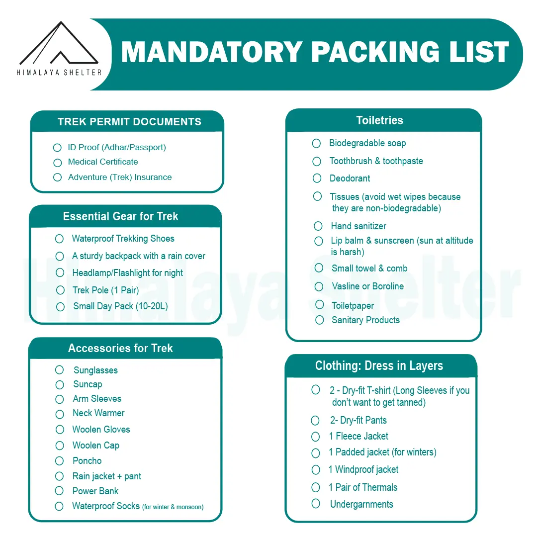
Mandatory Backpacking List for Aancha Top Trek
Clothing and Backpack
Get a good backpack (50 L) with a rain cover. Look for a bag that can provide you good back support. Pack 4 quick-dry t-shirts and 2 trekking pants. Get a pair of thermals (upper and lower) for night. Pack a fleece jacket or woolen sweater as a mid-layer. Get a waterproof wind breaker for sudden rain and chilly winds. For winter trekking, get a good down jacket. Now pack a woolen beanie and a balaclava. Get two pairs of gloves (woolen and waterproof). You should also pack a suncap for the daytime.
Footwear
You should look for good quality trekking shoes. Your shoes must be waterproof and provide good ankle support. Do not wear a new pair of shoes on the trek. Your feet must be familiar with the shoes. Now pack 4 pairs of trekking socks and 2 pairs of woolen socks. Pack a pair of comfortable slippers or sandals for the campsite.
Personal Care
For personal care items, start packing with your toiletries. Get a small zipper pouch and pack all the toiletries. Now look for a quick-dry towel and a toilet roll. You should also pack hand sanitizer and moisturizer. Pack a sunscreen that can protect your face from sunburn. You can also pack some snacks for the trek.
Physical Fitness Preparation for Trek:
To overcome the difficulty level of trekking, it requires strong cardiovascular endurance, muscular strength, and overall physical fitness. Incorporate these exercises into your routine to increase strength, stability, and stamina, which will help you tackle difficult terrain sections of the trail at high altitudes.
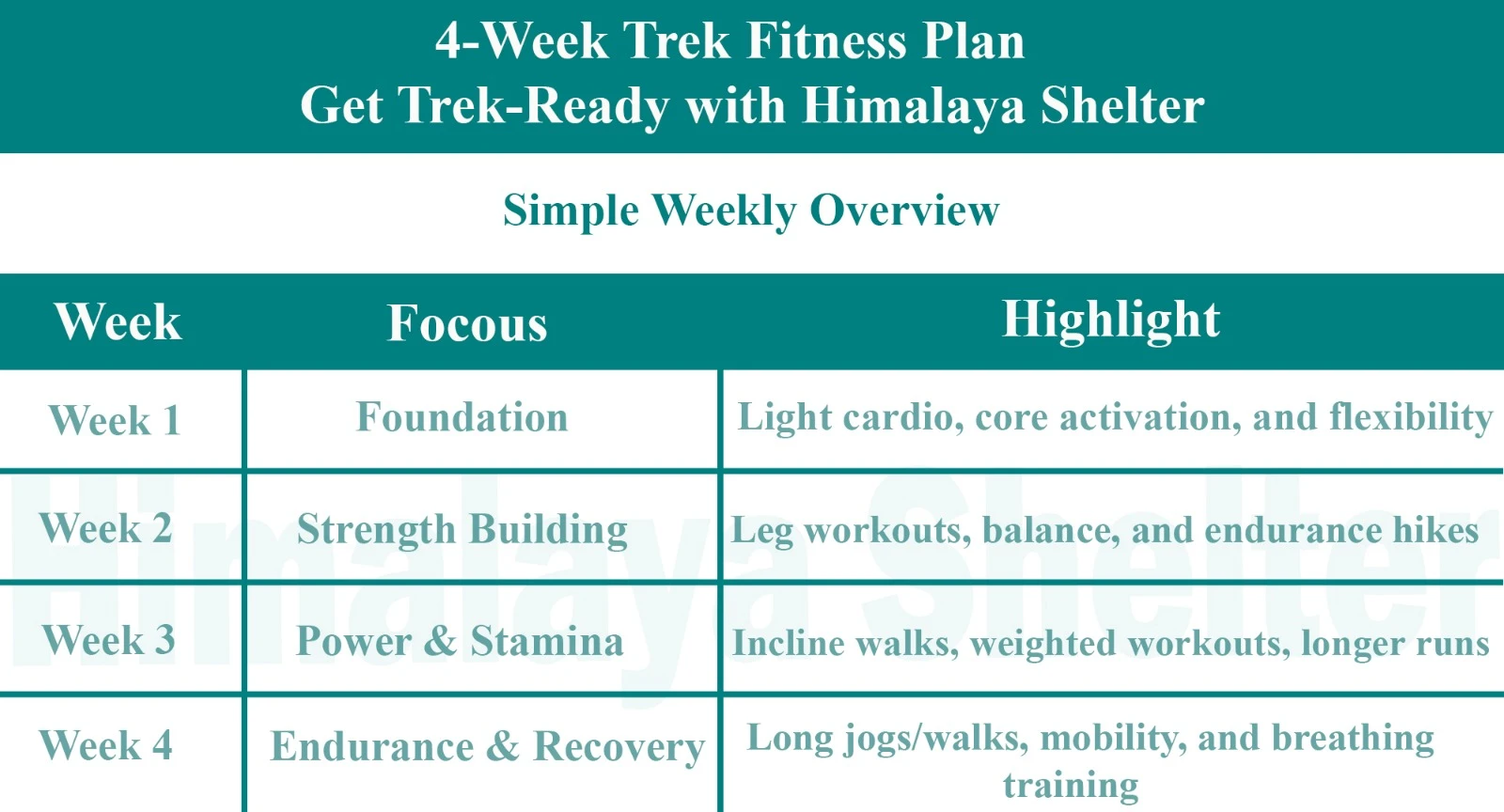
Overview

Foundation
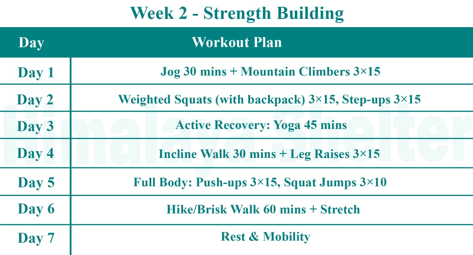
Strength Building

Power & Stamina
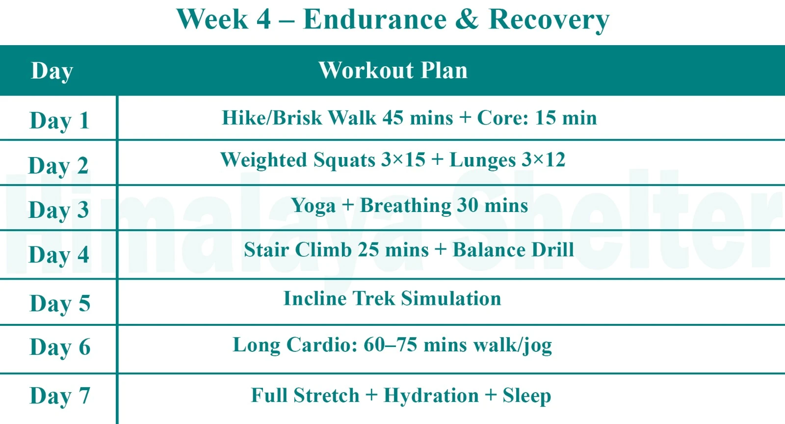
Endurance & Recovery
Day 1: Dehradun – Chopta (190 kms ) 8 - 9 hours drive
We start early in the morning from Dehradun via road towards Chopta. After a long drive through the winding roads lined up with alpine trees and some awe aspiring views of water streams, rivulets and mountain landscapes, we enjoy sumptuous dinner and stay at this location overnight in our camps.
Day 2: Chopta – Chitra Gufa (15 kms) 6-7 hours
We start early morning after sumptuous breakfast to trek towards Chitra gufa. Gufa literally means “ Cave” and “ Chitra “ means paintings. These are man made caves with paintings which form a part of ancient History of Uttarakhand. We camp nearby overnight.
Day 3: Chitra Gufa – Bisurital (15 kms) 6-7 hours trek
After a delicious breakfast we head towards our destination Bisurital. The Altitude is approximately 4000 mts at this point. The trek is strenuous at certain locations with covered dense alpine forests housing Himalayan Wildlife and birds. We camp here for the night after a heart filling dinner.
Day 4: Birsutal – River Akash Gamini (15 kms) 6-7 hours trek
After early breakfast we continue our trekking expedition towards River Akash Gamini. We camp here overnight.
Day 5: River Akash Gamini - Chopta (15 kms) 6-7 hours trek
After early breakfast we continue our trekking expedition towards Chopta to head back to Dehradun via road. We camp at Chopta after dinner to stay overnight.
Day 6: Chopta - Dehradun (190 kms ) 8 - 9 hours drive
After early breakfast we start our return journey to Dehradun via road to conclude our expedition. We reach Dehradun station early evening.
Our treks are specially designed by the experienced team at Himalaya Shelter, taking you on an adventure of a lifetime, all while making you connect not only with the bountiful nature but also with yourself and with others on the trek with you, creating wonderful memories that will last you a lifetime. All Himalaya Shelter treks are guided by experienced Trekkers having vast knowledge and experience of the region, providing with insightful information and stories pertaining to the region’s flora and fauna and the history of the region,n whilst the trek. It is safe to say that on successfully completing the trek, one will gain tremendous insight and experience along with lifetime memories.
Inclusion
- Transport support from Dehradun to Dehradun ( Pick-up location: Prince Chowk, near Dehradun Railway Station )
Pick-up Time: Around 7:30 am - Accommodation – At Base Camp, stay at a local homestay or guest house for one night each, which will give you an insight into the authentic lifestyle of the locals.( INR 5000 per person extra for single sharing throughout the trek )
On Trek stay in a 2-person Vango Halo Pro/A-Shape tent, which is to be shared by two trekkers, built to withstand extreme weather conditions and at the same time making you comfortable after a hard day’s trek. - Camping Equipment – specially designed sleeping bags that can withstand harsh weather conditions, foam mattresses. Other safety gear like microspikes, gaiters, an ice axe, and helmets will be provided.
- Medical Kit – our team will be equipped with an extensive medical kit, which our team is trained and experienced to use. Oxygen cylinders are used after they are thoroughly inspected throughout the Trek. Even campsites have large oxygen cylinders as backups.
- Permission - Forest entry charges for Indian nationals (Additional charges will be applicable for international tourists)
- Meals – Breakfast, packed lunch (on trek days), evening snacks, and dinner will be served. A hearty, delicious, and nutrition-filled Veg meals with egg preparation will be provided throughout the trek. (Jain and Vegan Food can also be arranged on prior notification.)There will be a dedicated Kitchen Tent along with a dining tent, which will have a dining table too.
- Our Team – A highly experienced and AMC-certified Trek Leader who will help ensure that the entire trek goes smoothly and safely while navigating the challenging conditions during the trek, and is skilled enough to navigate any medical emergency that can arise during the trek. Local and route Guides who are well-versed with the region and provide an in-depth insight into the local customs and knowledge of the flora and fauna endemic to the region. A dedicated Kitchen staff, which includes a Cook, a helper, and other support staff. There will also be porters and mules to carry common equipment.
- Cloakroom - We have a cloakroom facility available for extra luggage. Every trekker is permitted to leave their luggage behind at no charge.
Exclusions
- Personal expenses like tips, personal medicines, phone calls etc.
- Travel Expenses - Travel expenses from your hometown to the mentioned Pick-Up Point are not included in the trek fee.
From the scheduled pick-up spot to the base camp, we have our own fleet of vehicles like Bolero, Innova, Dezire, or Tempo Traveler (12-seater). This is be shared by trekkers for a pre-decided amount. All vehicles are non-AC. - Personal Equipment - Any personal gear like jackets, shoes, cutlery, or backpacks are not included in the trek fee. We recommend renting them from our Rental Store for an affordable fee. This can be pre-arranged to avoid last-minute hang-ups.
- Offloading - We encourage carrying your backpack to get into the true spirit of trekking. However, if needed, you can opt to offload your personal luggage of up to 12 kgs for an additional cost of INR 400 per bag per day.
- Trek Insurance - A mandatory trek insurance fee is charged in addition to your trek fee. Since most medical insurance doesn’t cover adventure activities, trek insurance offers essential coverage, enhancing your safety without a significant financial burden.
- Buffer day on the trek - We have kept a buffer day on the trek to account for any weather-related delay. If this is utilized, you will need to pay an extra amount to your trek leader.
- Anything apart from inclusions
- Please carry a lunch box for a packed lunch/breakfast to avoid using polythene and Aluminium foil.
Keeping the Himalayas clean is our own responsibility. Reduce the use of Plastic when you are in the abode of the Sacred Himalaya. 🌱
In the Chamoli district of Uttarakhand, India.
Approximately 4,100 meters (13,450 feet).
No, it's moderately difficult and better for experienced trekkers.
From Chopta or Sari village, depending on the route.
May–June and September–October.
Yes, trekkers camp near the lake.
Yes, forest permits are needed.
No, a certified guide or support team is highly recommended.
Alpine meadows, rhododendron forests, less crowded trails, peaceful atmosphere, Pristine Bisurital Lake, Himalayan views.
Yes, Bisurital is glacier-fed.
Forests, meadows, steep ridges and rocky sections.
Not well-marked; remote and requires local knowledge.
Read More on Bisurital Trek
Treks by Categories
Treks By Month

Treks By Experience


