Bali Pass Trek
6 Lakh+
Satisfied Trekkers
16+
Years of Experiance
1300+
Google Reviews
800+
Tripadvisor Reviews
Duration
8 Days
Difficulty
Difficult
Max Altitude
16,240 Feet
Region
Uttarakhand | India
Pickup
Dehradun (Prince Chowk)
Best Season
Summer | Autumn
Quick Information
Trek Duration
8 Days
Trek Difficulty
Difficult
Trek Group Size
12 max
Trek Distance
66 Km
Trek Max Altitude
16,240 Feet
Trek Region
Uttarakhand | India
Trek Pickup
Dehradun (Prince Chowk)
Best Season
Summer | Autumn
Best Time
May, June, September, October
Trek Basecamp
Bali Pass Trek, Uttarakhand
Trek Backpack Fee
₹ 400
GST Fee
5%
Bali Pass Trek Overview
Bali Pass is a mountain pass that peaks slightly short of the 5000-meter mark and connects the Har Ki Dun - Ruinsara Valley to Yamunotri and vice-versa. The Bali Pass trek runs through numerous heritage Villages of Har Ki Dun Valley such as Osla, Gangaad, and Taluka, and ascends deep into the Govind National Park. On the route, we come across the beautiful Ruinsara Lake. Multiple Waterfalls lie on the way to the pass.
The Bali Pass trek distance is 66 KM from Taluka to Janki Chatti. The trek is on the difficult end as the Bali Pass trek altitude is more than 16000 feet and has long walking days, with steep ascents and descents. If one plans to attempt the Bali Pass trek solo, it is highly advised to trek along a route guide as it is easy to misjudge the trail while descending or ascending the pass, with steep sections that can cause mishaps.
Places to visit and Highlights of the Bali Pass Trek
Thanga and Devsu Thatch/Meadow
An alpine pasture 1 km from Ruinsar Lake, Thanga Bugyal is an area. It has a beautiful view of Kyarkoti Bugyal and a 2 km ridge walk with white rhododendron blooms along the way.
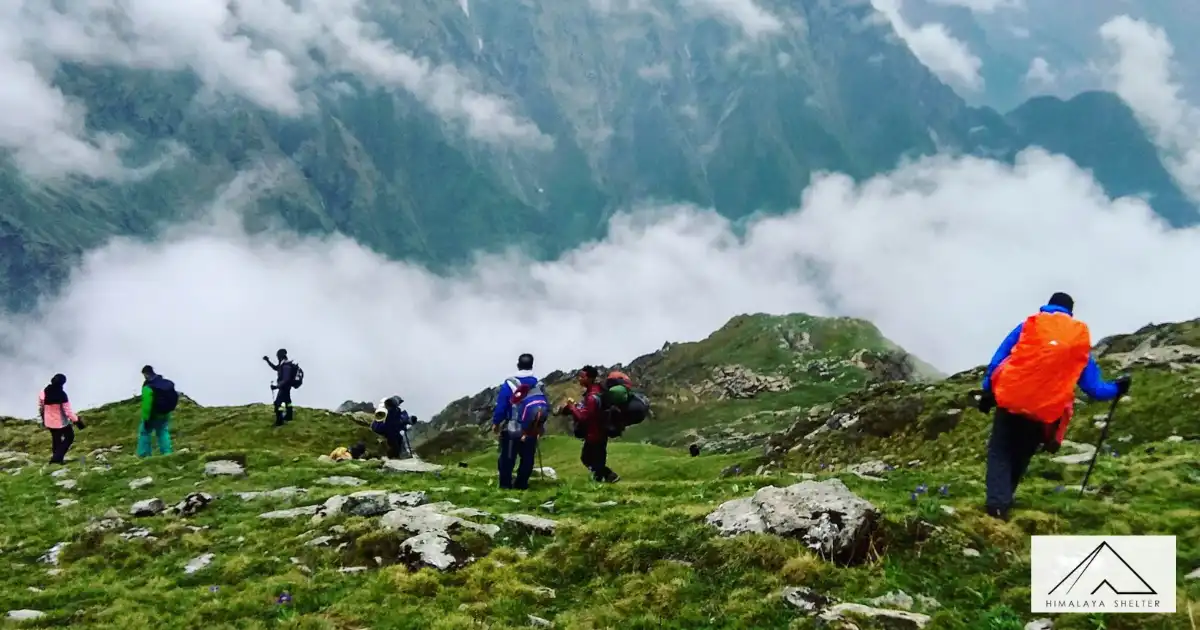
Devsu Thatch is a huge grassland along the way from Puani Garat to the Waterfall on the Supin River, & it is at 10,032 feet high. Day 3 was surrounded by heavy trees. There are well-kept grass mounds. And a variety of flowers, such as orchids, poppies, anemones, primulas, daisies, and marigolds. it offers a stunning experience. Barefoot walks on lush grass turn into a sensory dance with nature, motivating a day of camping to appreciate beauty.
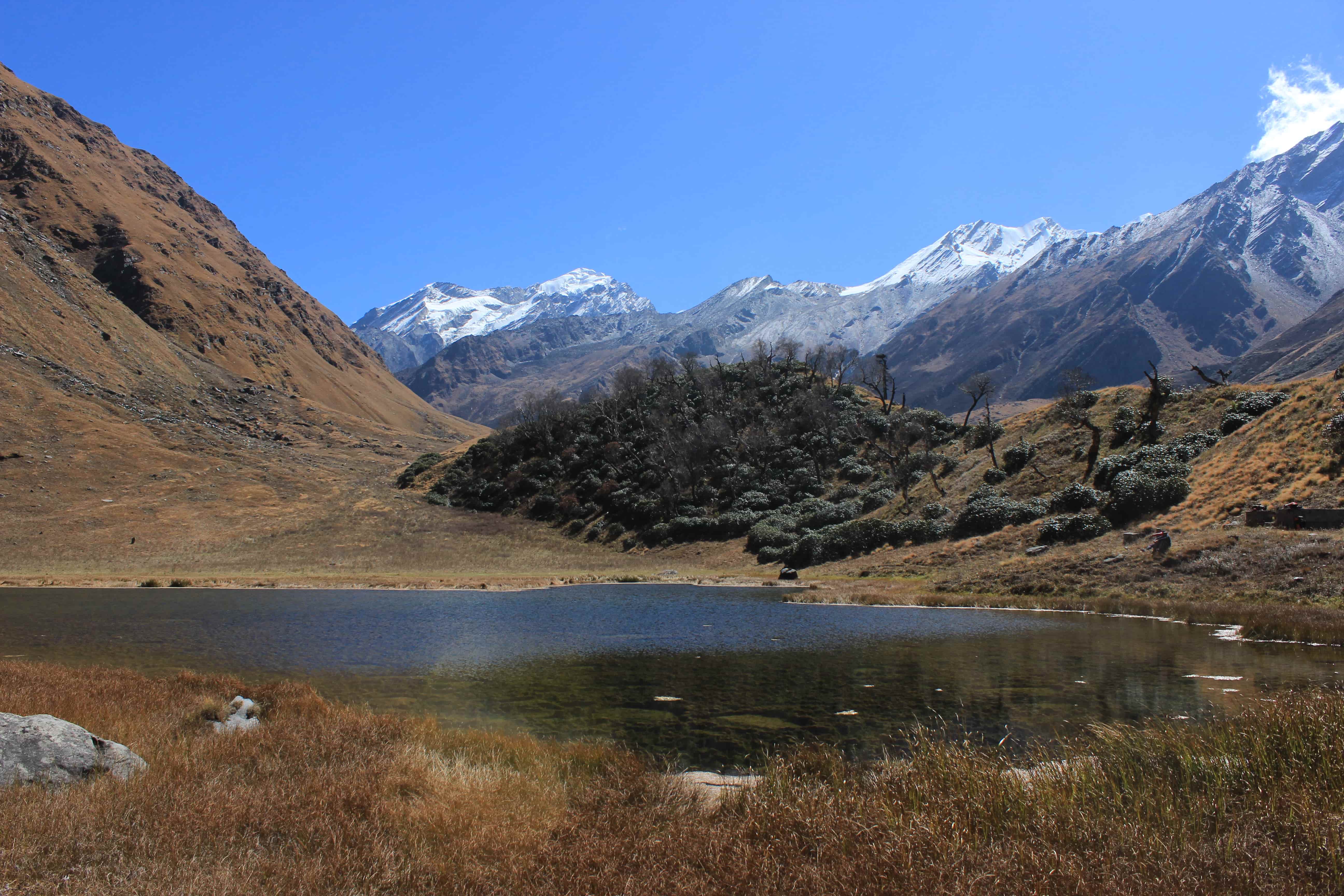
Ruinsara Lake
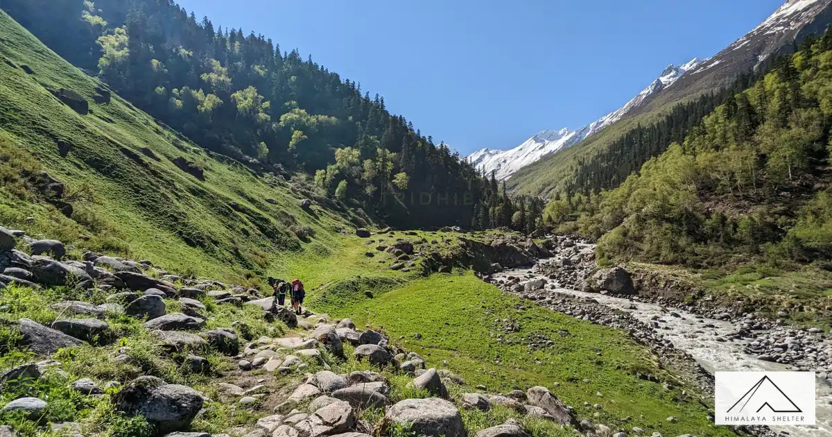
Standing at 11,483 feet (3,500 meters), Ruinsara Lake is a crucial point on the Bali Pass path, showcasing the beauty of Govind National Park with brilliant flora- particularly orchids. Along the Tons River through quaint communities like Gangad, Seema, and Osla, the trail winds. A day at Ruinsara Lake lets visitors explore close to the Black Peak base camp and Banderpoonch glacier.
Kyarkoti Glacier
This is the base camp for the Kalanag, Swargarohini, and Dhumdhar Kandi Trek, located around 8 kilometers from Ruinsara Bugyal. Starting for the Tons River, which comes from the Kyarkoti Glacier, it is at an altitude of 12,795 feet (3,900 meters) above sea level.
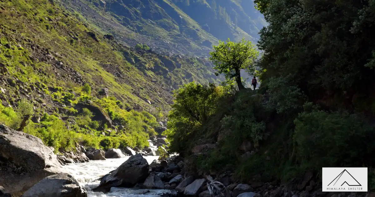
Waterfalls
The beauty of the 66 km Bali Pass trail is enhanced by the many waterfalls you meet. Particularly, the third day's trip across Seema and Swarn Dhara includes some stunning waterfalls that very much improve the magic of the entire hike.
Yamunotri Dham
Coming down from Lower Dhamini to Yamunotri, you will locate the holy Yamunotri temple, one of the Chota Char Dham in Uttarakhand. It is a particularly great location for trekkers as well as pilgrimsas it is found in the center of the Himalayas. For everyone who comes here, the tranquil surroundings offer a peaceful refuge; respect and calmness fill the air.
Saptrishi Kund
Towards the end of the Bali Pass walk, the magnificent Bandarpunch Glacier and Saptrishi Kund materialize as the actual origin of the Yamuna River.
Located at 4,421 meters, Saptrishi Kund is a high-altitude lake and the main source of the Yamuna. Formed by the commanding Bandarpunch Mountain, this lake is surrounded by rock glaciers, adding to the magnificence of the terrain.
Exploration of the Govind Wildlife Sanctuary and National Park
- Flora: Deodar cedar, Chir pine, Oak, and conifers like Spruce, Blue pine, and Silver fir.
- Fauna: Himalayan snow leopard, Himalayan black bear, Brown bear, Monal pheasant, Bearded vulture, Golden eagle, Western tragopan, Steppe eagle, and Black eagle.
High altitude and challenging terrain of Bali Pass Trek
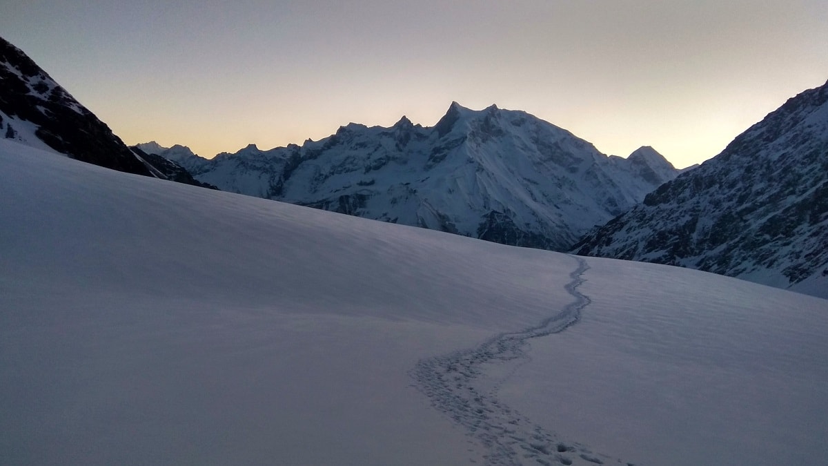
At a stunning height of 16,240 feet (4,950 meters), this walk You will travel quite a distance in the early stages of trekking to the Bali Pass on generally moderate slopes until the Ruinsara Lake. 1012 kilometers on an average day. The altitude will next rise until the base camp, when the elevation will be roughly 3,000 feet in one day followed by an additional 1,000 feet the following day.
From Bali Pass to Yamunotri is steep; the altitude drops around 8,000 feet in only two days.
Village Exploration
Exploring the village of the Har Ki Dun Valley (Datmir, Gangad, Puani, and Osla) and the Yamunotri Valley (Kharsali, Hanumanchatti, and Jankichatti). iscover local customs and agricultural techniques of both valleys and see many different building styles.
More Information
Bali Pass Trek Route Map
The Bali Pass trek route map shows you the way across the stunning Garhwal Himalayas. It takes you past the charming Devsu Bugyal and Ruinsara Lake to reach the stunning Bali Pass at an impressive altitude of 16,200 ft. Following the scenic route along the Supin River, the map points out the awe-inspiring sights of snow-capped peaks and lush meadows. It promises an exciting adventure for both trekkers and nature lovers.
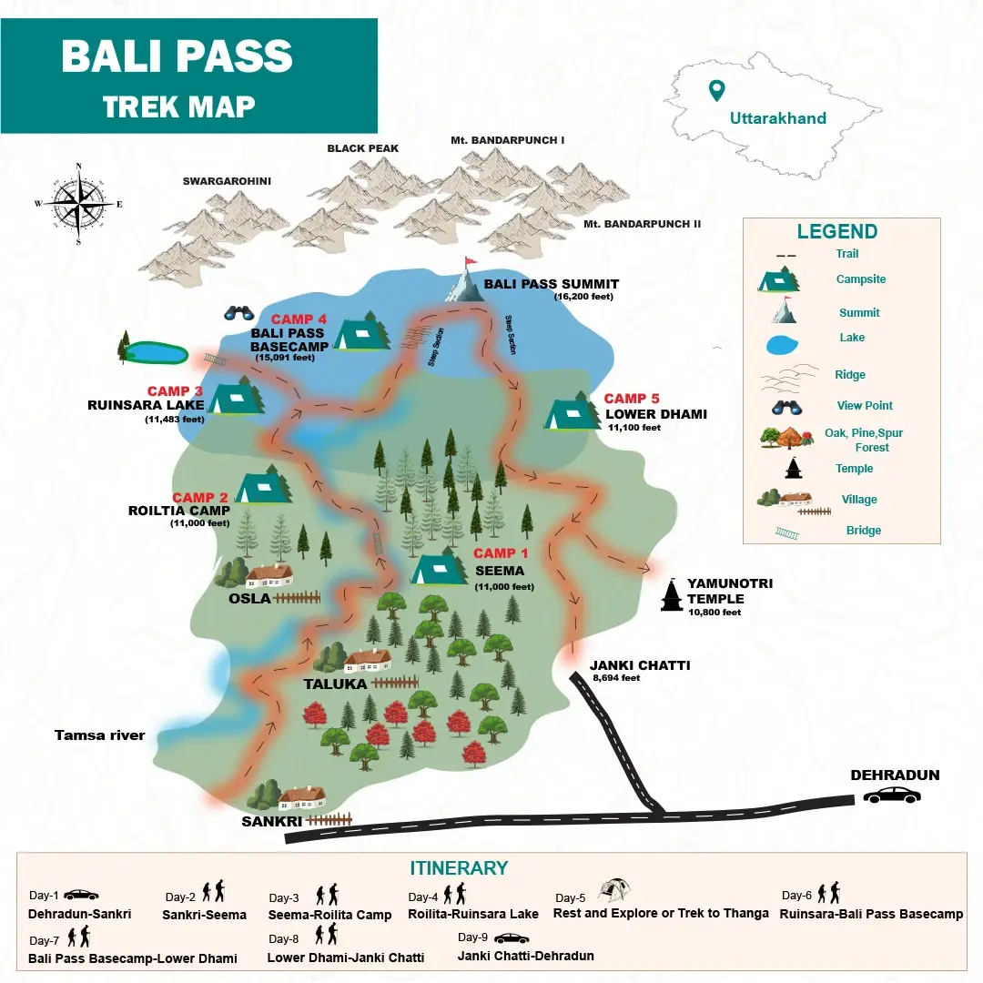
Bali Pass Trek Route Map
Bali Pass Trek Route & Terrain
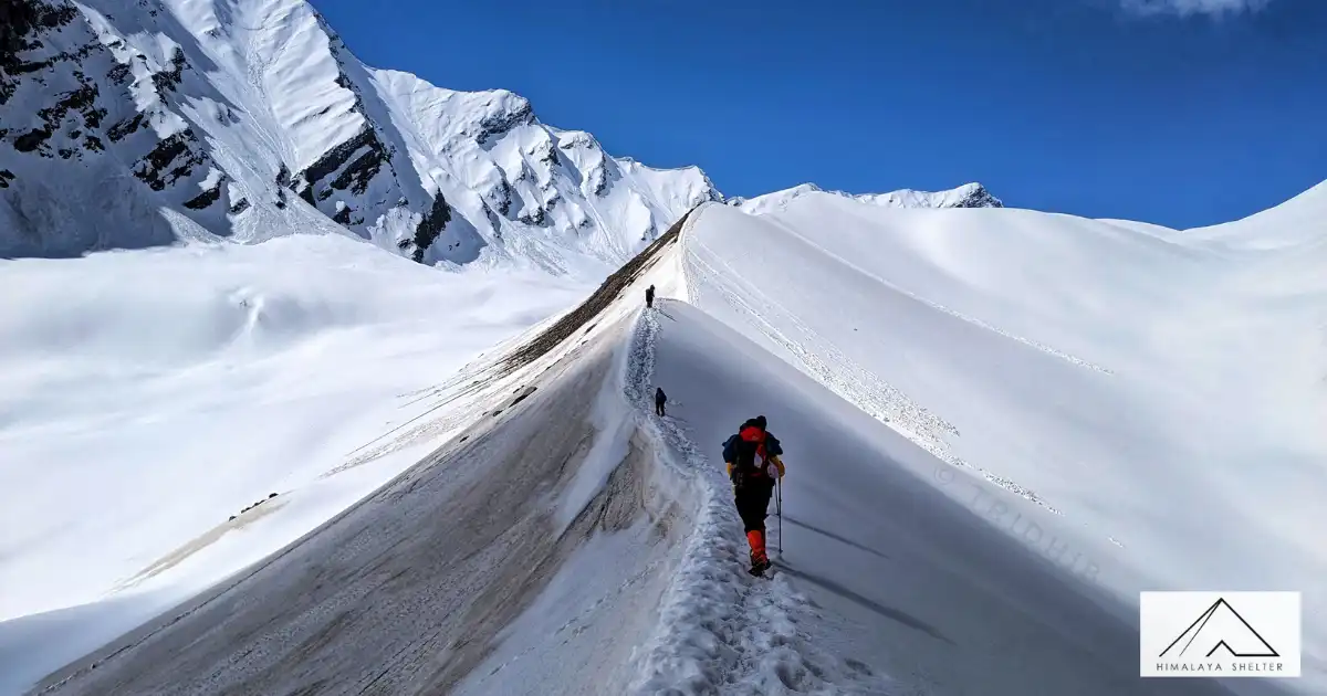
Bali Pass Trek Route goes through some of the most thrilling and dramatic landscapes of the Himalayan region. This is a high-altitude pass that connects the Har Ki Dun valley to the sacred Yamunotri region. The trail passes through some ancient villages, dense forests, meadows, glacier sections, and rugged mountains. Bali Pass Trek is best known for its raw Himalayan beauty, challenging ascents, and breathtaking views of peaks like Swargarohini, Kala Nag, and Bandarpoonch.
- Sankri village is the basecamp for Bali Pass Trek. This is one of the most popular basecamp villages in Uttarakhand as it acts as a starting point for treks like Har Ki Dun Trek, Phulara Ridge Trek, Borasu Pass Trek, etc. Sankri is about 190 km from Dehradun, and the drive goes through Mussoorie, Naugaon, Purola, and Mori. After crossing Mori, we will enter Govind Wildlife Sanctuary.
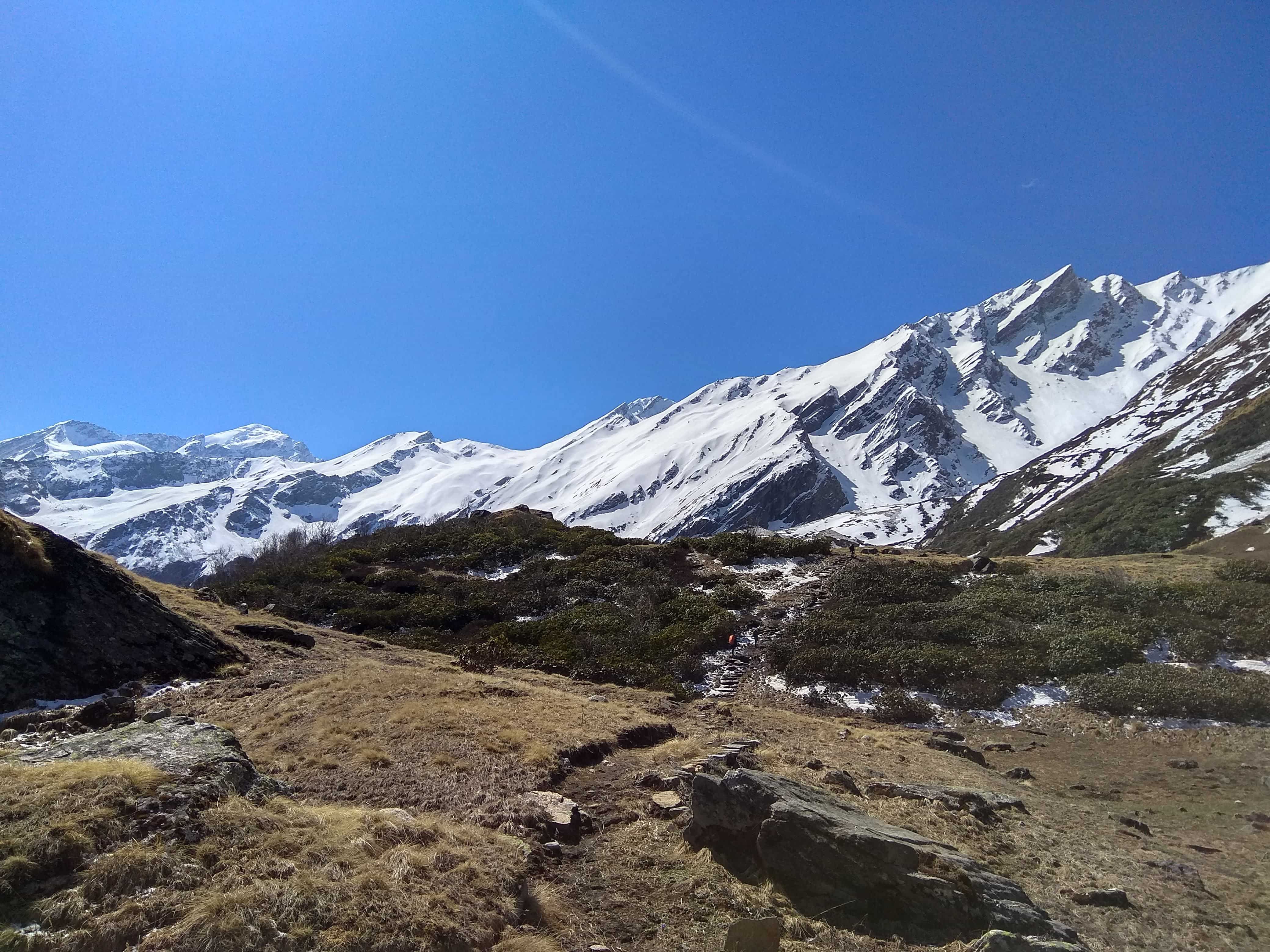
- The Bali Pass Trek starts from Sankri and gradually heads to Taluka through the Supin Valley. The trek is forested with pine, walnut, deodar and rhododendrons while listening to the sound of the Supin River accompanies the trekker throughout the trek.
- The trail is more rugged and adventurous after crossing the Har Ki Dun Valley. The path continues on to Ruinsara Tal, a beautiful alpine lake with meadows and snow-capped mountains. The ascent from Ruinsara Tal to Odari and then to Bali Pass Base Camp is becoming rather steep and rocky. Depending on the season loose moraines, glacier patches, narrow ridges and snowfields are encountered by the trekkers.
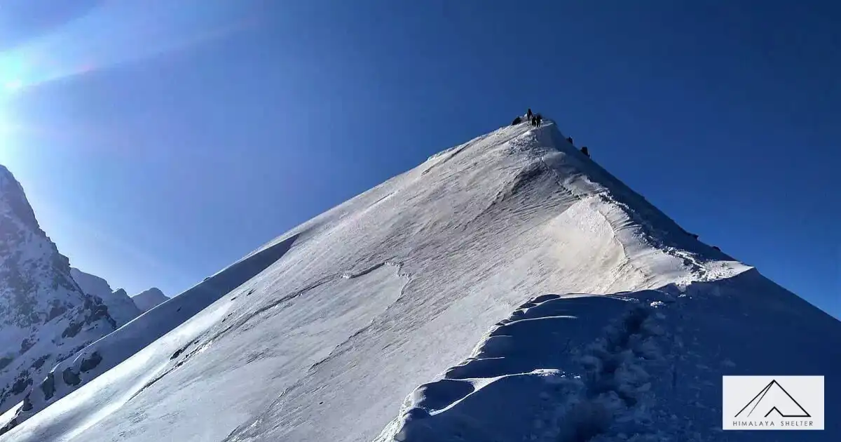
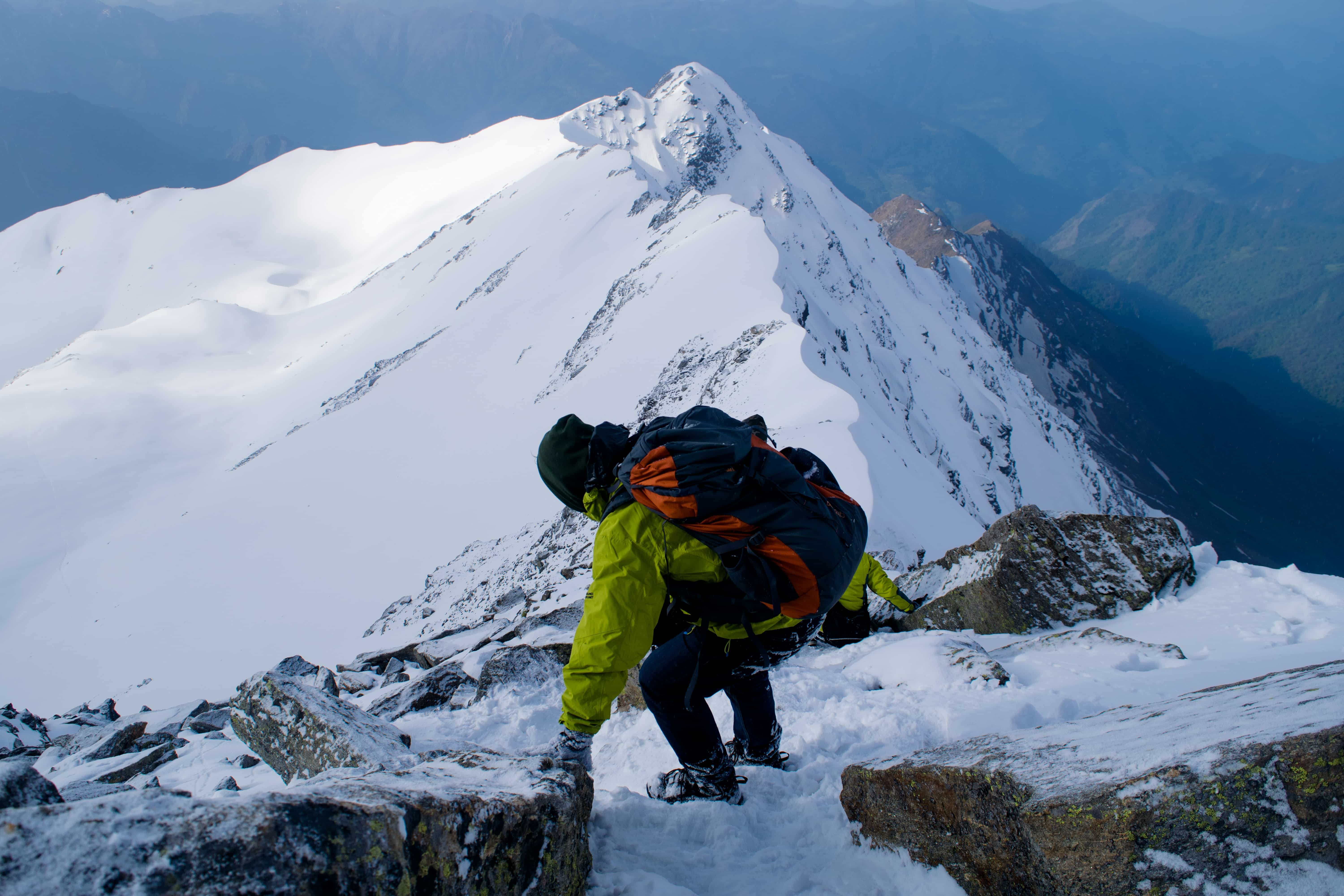
- The most difficult part of the trek is the ascent to Bali Pass. The pass is about 4950m high, and requires fitness and endurance. Usually starts before dawn and requires walking on steep snow slopes and rock. Trekkers get a great panoramic view from the summit of Bali Pass, of Swargarohini, Bandarpoonch, Black Peak (Kala Nag) and the adjacent ranges of the Himalayas.
- The descent towards the Yamunotri is steep and difficult after crossing the pass. The path passes through snow patches, rocky areas and narrow footpaths leading to the sacred temple of Yamunotri. The walk is challenging in terms of endurance and hiking technique, particularly in early summer due to heavy snow on the trail.
- The Bali Pass Trek is one of the most beautiful treks in Uttarakhand as it entails mythology, the remote Himalayan culture, the difficult path and the amazing mountain landscapes. The trek also provides a rare chance to see the contrasting landscapes of Har Ki Dun valley and Yamunotri region in a single trek.
- The Bali Pass Trek ends at Janki Chatti, after descending from Yamunotri, and then heading back towards Dehradun. The trek is suitable for experienced trekkers who are seeking a challenging journey through the Himalayas, with diverse scenery, high passes, and memorable moments.
Bali Pass Trek Short Itinerary
Day 1: Drive from Dehradun to Sankri (190 km) | Guest House
Day 2: Drive from Sankri to Gangad (20 km) and trek to Chilurgad (4 km) | Alpine Tent
Day 3: Trek from Chilurgad to Devsu Camp (4-5 km) | Alpine Tent
Day 4: Trek from Devsu Camp to Ruinsara Lake Campsite (4-5 km) | Alpine Tent
Day 5: Trek from Ruinsara Lake Campsite to Thanga (7 km) | Alpine Tent
Day 6: Trek from Thanga to Bali Pass Basecamp (6 km) | Alpine Tent
Day 7: Trek from Bali Pass Basecamp to Lower Dhamni via Bali Pass (10 km) | Alpine Tent
Day 8: Trek from Lower Dhamni to Yamunotri to Janki Chatti (8 km) and drive to Dehradun (182 km)
Bali Pass Trek Itinerary
Drive: 190 km, 8 hrs
Altitude Gain: 2,100 ft-6,400 ft
Accomodation: Guest House
Meals: Dinner
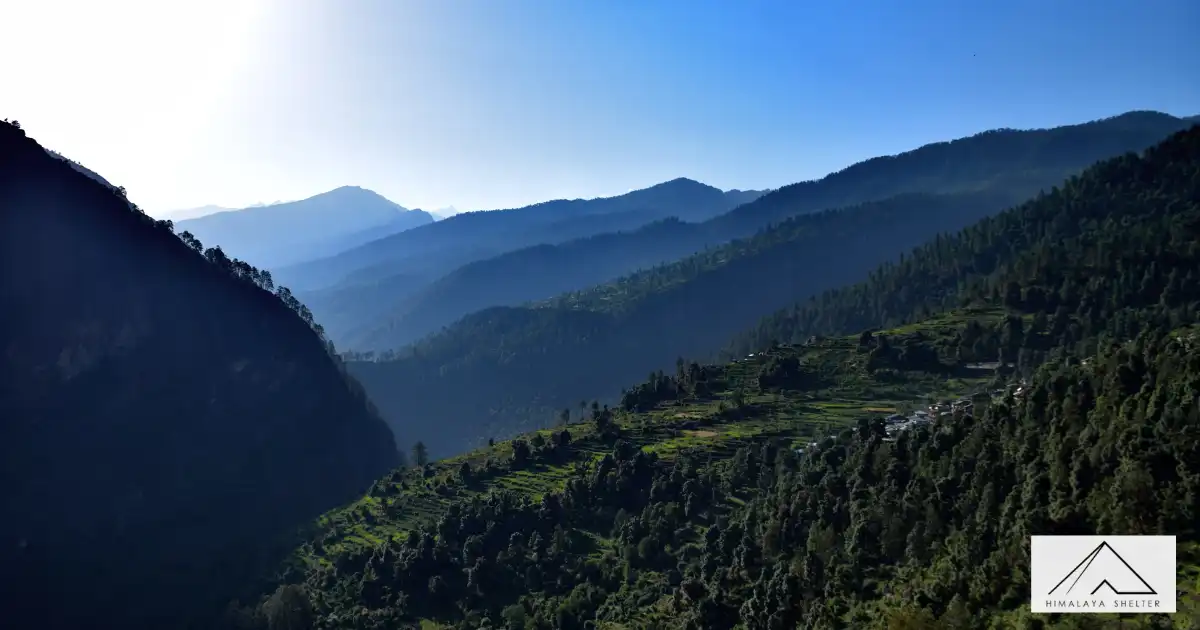
Our journey begins from Dehradun, making it a good option for people looking for treks near Delhi. Driving alongside the Tons river, and passing villages in Uttarakhand like Damta, Purola, Mori, and Netwar, we will reach the base camp Sankri. There is no network in this village, letting us take in the sight of the sun gloriously setting over the surrounding Greater Himalayan peaks without any distractions. We will be accommodated in hotels or homestays here.
After a hearty breakfast, we will be transported to Gangad by car. The motorable road in Govind Pashu National Park ends here. The trek commences on a stony path alongside the gushing river Supin. We also see plantations of the red-coloured Himalayan crop amaranth, locally known as cholai. Under the shade of walnut, pine, deodar and maple trees, the walk is as pleasant as the villagers greeting us on the way. We will trek for about 4-5 km and will reach Chilurgad by the early afternoon.
We will start trekking towards Devsu Camp early in the morning. After some walking, we will reach Seema where you can dhabas and a GMVN guest house. The trek commences on a stony path alongside the gushing river Supin. We also see plantations of the red-coloured Himalayan crop amaranth, locally known as cholai. Under the shade of walnut, pine, deodar and maple trees, the walk is as pleasant as the villagers greeting us on the way. We will trek for about 6 km and will reach Devsu Camp by afternoon.
After having a warm breakfast, we will start trekking towards Ruinsara Lake. Pine trees give way to birch and rhododendron trees. The thick forest we trudge through is frequented by the endangered Himalayan brown bear. If we are very lucky, we might spot this rare and elusive creature.
We then reach one of the highlights of the trek — Ruinsara Tal, an alpine tarn, surrounded by lush Rhododendron trees, with their distinct pink bloom in the summers. We will be left enchanted by this sacred lake in the Uttarakhand Himalayas. It is one of the trio of lakes in the Garhwal region, the other two lakes being Marinda and Maldaru. We will be camping overnight near the lake.
Lying at an elevation of about 3500 m, Ruinsara lake is a good place to acclimatize. Today we will leave Ruinsara Lake Campsite and will proceed to Thanga. We start the day early so as to reach our destination on time. We descend down to the shallow river bed, cross over to the opposite bank and walk uphill to another beautiful meadow – Thanga. This meadow also offers awe-inspiring views of the seemingly omnipresent Swargarohini ranges. Kyarkoti valley lies towards the left.
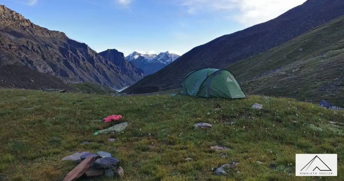
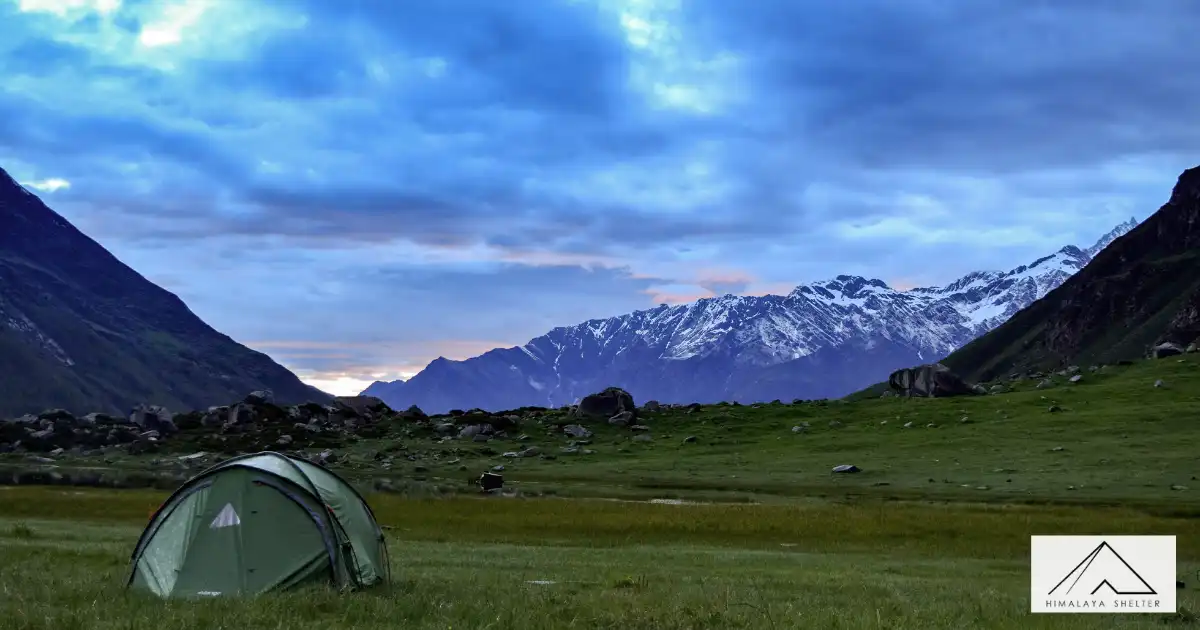
Today we will trek from Thanga to Bali Pass Basecamp via Odari. The word ‘Odari’ means a naturally made cave rock. This place has a mythological story associated with it. It is believed that Bali, Hanuman’s brother, had stayed here for one night. Here too we might find evidence of the rare Himalayan brown bear. We camp below Bali Pass along a glacial moraine. This is the one of the best locations for a camp, with the valley below and the Pass behind us. The temperatures at night tend to go to sub-zero degrees. Camping at this altitude is a unique experience which very few treks offer.
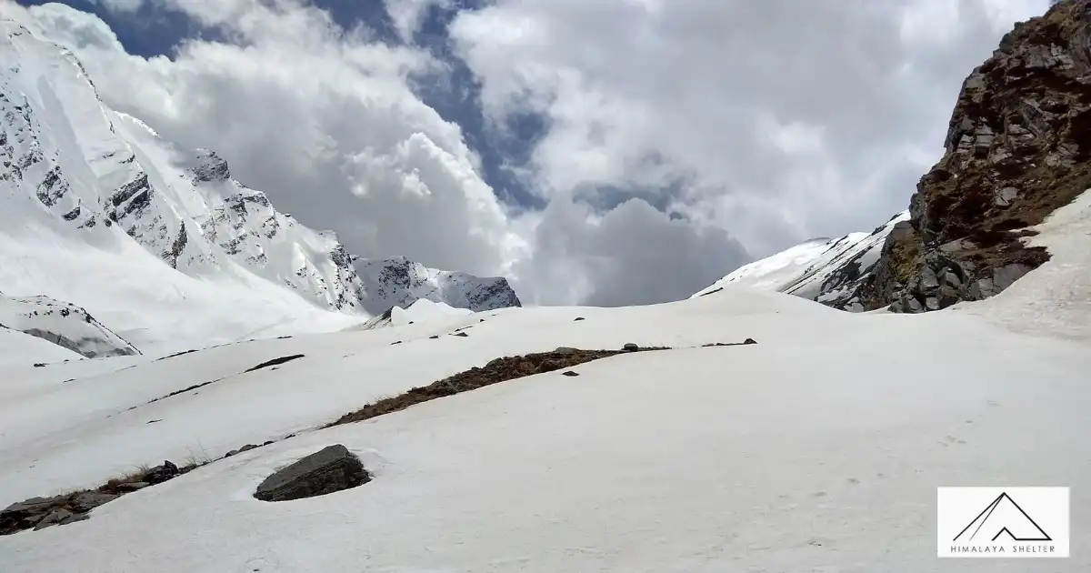
This day of crossing Bali Pass too begins very early. We strive to reach the summit by 8am. The trail heads down south, over a ridge. It is a fairly short but steep climb up to the Pass. A lot of glacial scree will be encountered here. Time taken to reach the top ranges from 45 minutes to one and a half hours.
Once we reach the top, we behold the Yamunotri valley for the first time. The view is breath- taking. We see hints of the Saptrishi Kund, which is the origin of river Yamuna. We also get to witness the Banderpunch peaks from the top of the Pass. The summits of Dayara Bugyal Trek, Barua Top and Dokrani Bamak are visible too. We then descend carefully via a connecting ridge and reach the camping grounds of upper Dhamni.
We descend further to a forested trail. This path leads us to the famous shrine of Yamunotri with the glorious Bandarpunch in its background. One of the temples in the Char Dham circuit, it is dedicated to Goddess Yamuna. After paying obeisance to her black marble idol, we make our way down the conventional pilgrim road to Janki Chatti. From Janki Chatti, we drive back to Dehradun. We can make the most of this journey by visiting other well-known places that fall on this route such as Kempty waterfalls, Nainbagh and Mussourie.
Difficulty Level of Bali Pass Trek Uttarakhand
Bali pass trek difficulty/ High altitude trek at At the height of altitude of 16,240 feet/4,950 meters. The Bali pass trek has a distance of 66 km, starting from Taluka to the endpoint at Janki Chatti. It takes 6 to 7 days to complete the trek on foot. Thus we will walk around 10 KM on average every day. The altitude of Taluka, where the trek starts, is 6,825 feet (2080 meters). We thus have a net altitude gain of 9,250 feet (2,820 meters) over a duration of 5 days, thus climbing an average of 550 meters a day or 1800 feet. That is a considerable altitude gain. The distance, altitude gain, and finally the technical pass crossing make Bali Pass fall in the category of a Moderate-Difficult trek. It requires physical preparation and regular exercises that must be started at least 1 month prior to trekking to the Bali Pass.
Bali Pass Trek - Best Trek for Experienced Trekkers
The Bali Pass Trek is one of the best high-altitude treks in the Indian Himalayas for adventure lovers who want to experience a true challenging expedition. Sitting at an altitude of around 16,200 ft, this trek is known for its difficult terrain, steep climbs, long trekking hours, snow-covered trails, and thrilling pass crossing.
Who Should Do Bali Pass Trek?
- Experienced Himalayan Trekkers (4,000+ m)
- Individuals with excellent fitness levels, good stamina & recovery abilities
- People who are comfortable walking on snow, rocks, or long days of trekking
- Adventure-seeker who wants a difficult high-alpine crossing trek
- Mentally strong individuals to deal with remote and unpredictable conditions
Who Should Not Do the Bali Pass Trek
- First-Time trekkers without any experience at high altitude and/or on snow
- Individuals who have serious health conditions related to the heart, lungs, and/or altitude
- Individuals who do not have the physical fitness level necessary or have not acclimatised to high altitude.
- Individuals who are looking for an easy trail or a comfortable trekking environment
Best Time To Visit Bali Pass Trek
The best times to do the Bali pass trekking are before and after the monsoon season, which happens in the summer and fall. Depending on how much snow fell the winter before, summer starts around the middle of May and lasts until the end of June, when the monsoon starts.
After that, the beautiful season of autumn begins in September and lasts until the end of October. These exact times not only guarantee good weather, but they also give trekkers a beautiful view of nature with bright colours and a variety of sceneries.
Bali Pass Trek in Summer (May - June)
- Flora: In summer, the forests and meadows transform into vibrant shades of green, adorned with blossoming flowers, creating a picturesque and refreshing landscape.
- Snow condition- As summer progresses, the accumulated snow and glaciers melt, revealing a vast expanse of icy snow.
- Weather & Temperature- The daytime warms up to 10°C to 20°C in Bali Pass Trek 2025, especially in sunny conditions. At night or early morning, the base temperatures range from 5°C to 10°C.
Bali Pass Trek in Autumn (September - October)
- Flora- In September and October, the scenery changes with colorful autumn leaves. Trees and grasses paint the surroundings in yellow, orange, and brown, offering a delightful sight.
Snow- In September, there is less snow, and by October, the likelihood of fresh snowfall increases. - Weather & Temperature- As you advance toward the Ruinsara Lake campsite and beyond, the weather significantly becomes colder. Daytime temperatures range from 5°C to 15°C in September and during nights or early mornings, temperatures range from 2°C to 8°C. In October, temperatures decrease noticeably, ranging from 5°C to 10°C. Be prepared for temperatures in the higher camps to drop below 0°C at night.
How to reach Bali Pass Trek
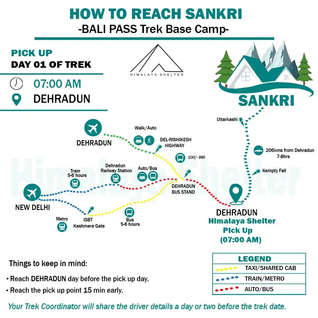
How to reach Sankri, basecamp of Bali Pass Trek
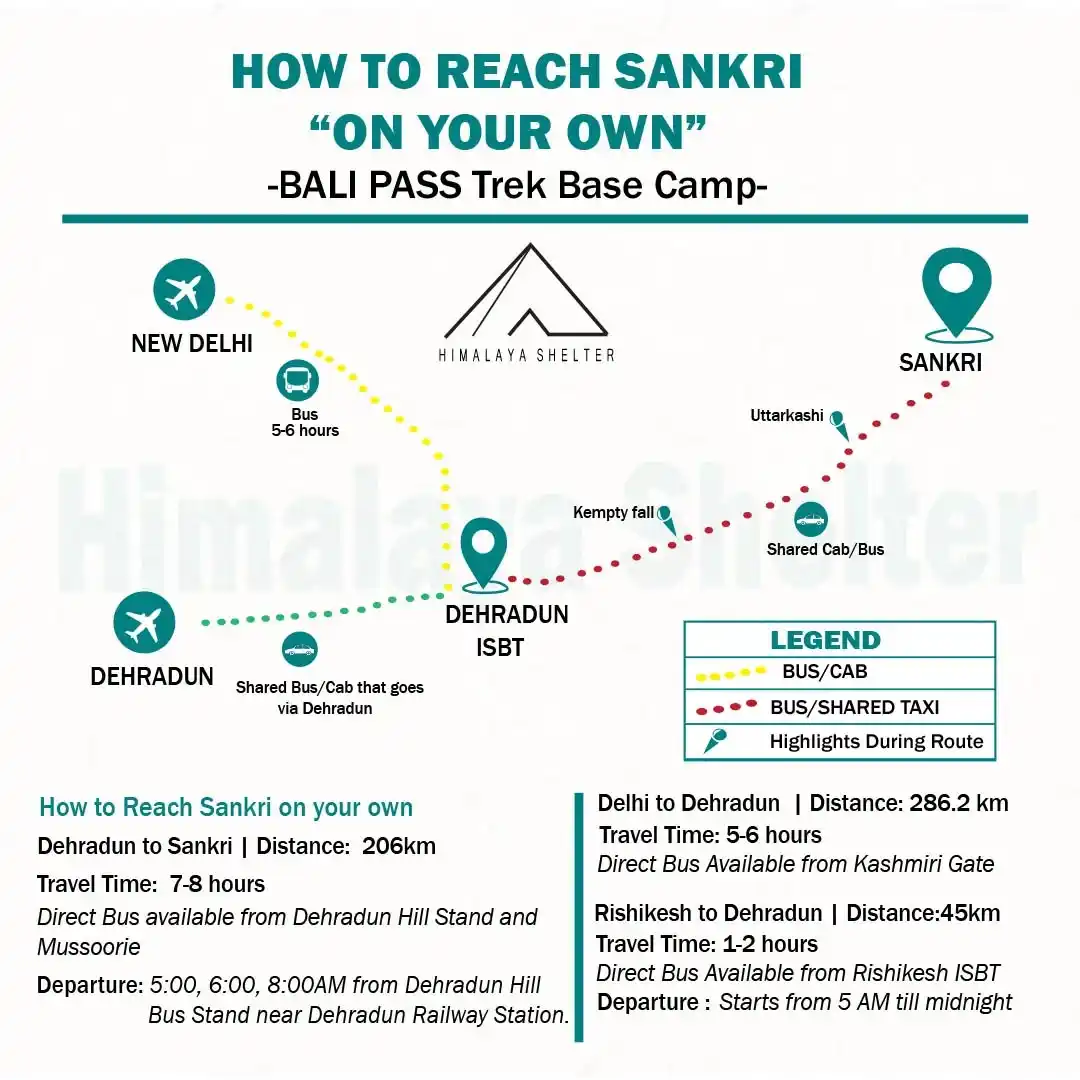
How to reach Sankri, basecamp of Bali Pass Trek"On Your Own"
How to Reach Sankri on Your Own
Bali Pass Trek Base Camp
Sankri is the base camp for the Bali Pass Trek. Trekkers can reach Sankri by travelling first to Dehradun and then taking a shared cab or bus to Sankri.
Route Overview
New Delhi → Dehradun → Mussoorie → Purola → Sankri
Delhi to Dehradun
-
Distance: 286.2 km Travel
-
Time: 5–6 hours
-
Transport Option: Direct bus is available from Kashmiri Gate, New Delhi.
Rishikesh to Dehradun
-
Distance: 45 km
-
Travel Time: 1–2 hours
-
Transport Option: Direct bus is available from Rishikesh ISBT.
-
Departure: Buses start from 5:00 AM and operate till midnight.
Dehradun to Sankri
-
Distance: 190 km
-
Travel Time: 8–9 hours
-
Transport Option: Direct bus or shared cab available from Dehradun Hill Bus Stand near Dehradun Railway Station.
-
Departure Timings: 5:00 AM, 6:00 AM, and 8:00 AM from Dehradun Hill Bus Stand near Dehradun Railway Station.
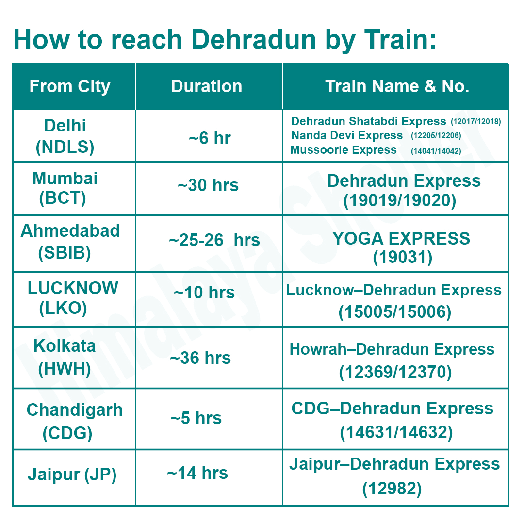
How to reach Dehradun by Train
How to Reach Dehradun by Train
How to Reach Dehradun by Train
|
From City |
Duration |
Train Name & No. |
|
Delhi (NDLS) |
~6 hr |
Dehradun Shatabdi Express (12017/12018), Nanda Devi Express (12205/12206), Mussoorie Express (14041/14042) |
|
Mumbai (BCT) |
~30 hrs |
Dehradun Express (19019/19020) |
|
Ahmedabad (SBIB) |
~25–26 hrs |
Yoga Express (19031) |
|
Lucknow (LKO) |
~10 hrs |
Lucknow–Dehradun Express (15005/15006) |
|
Kolkata (HWH) |
~36 hrs |
Howrah–Dehradun Express (12369/12370) |
|
Chandigarh (CDG) |
~5 hrs |
CDG–Dehradun Express (14631/14632) |
|
Jaipur (JP) |
~14 hrs |
Jaipur–Dehradun Express (12982) |
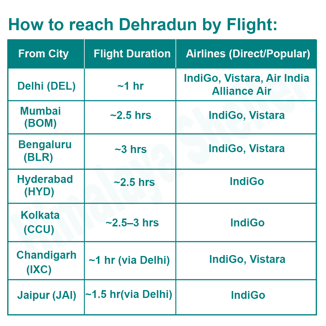
How to reach Dehradun by Flight
How to Reach Dehradun by Flight
From City |
Flight Duration |
Airlines Direct/Popular |
|
Delhi (DEL) |
~1 hr |
IndiGo, Vistara, Air India, Alliance Air |
|
Mumbai (BOM) |
~2.5 hrs |
IndiGo, Vistara |
|
Bengaluru (BLR) |
~3 hrs |
IndiGo, Vistara |
|
Hyderabad (HYD) |
~2.5 hrs |
IndiGo |
|
Kolkata (CCU) |
~2.5–3 hrs |
IndiGo |
|
Chandigarh (IXC) |
~1 hr via Delhi |
IndiGo, Vistara |
|
Jaipur (JAI) |
~1.5 hr via Delhi |
IndiGo |
What to Pack for the Bali Pass Trek?
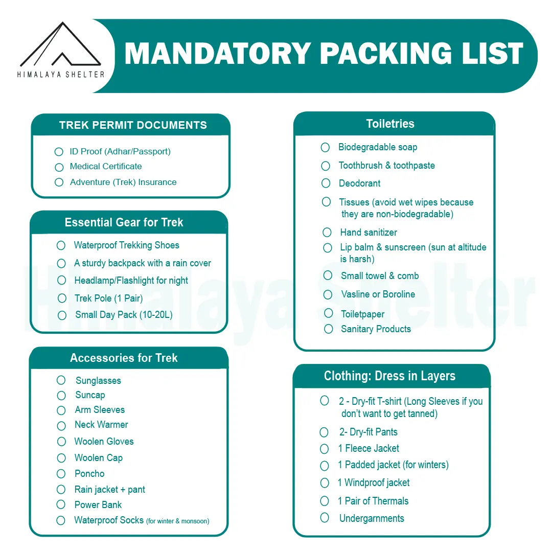
Mandatory Backpacking List for Bali Pass Trekking
Before going on the Bali Pass Trek you need to have the best knowledge on how to prepare for a Himalayan Trek with a perfect backpacking of gear and equipment required, so that you can enjoy the trek without worrying about the common requirements otherwise lack of proper backpacking preparation can lead to the worst experience of your beautiful trek. Follow the instructions below to pack your backpack for hiking-
Mandatory Documents
Ensure you carry essential documents such as a valid ID proof (driver’s license, Aadhar Card, or passport), medical fittness certificate and an adventure insurance.
Accessories
Bring along a sturdy Backpack with rain cover, Waterproof Shoes, trekking poles, sun cap, sunglasses, headlamp or flashlight, lunch box, water bottle, a trek route map & current weather forecast of the the trail' region. Don't forget to carry a camera to capture the scenic beauty of Bali Pass Trek, and a power bank for charging electronic devices.
Toiletries
It's essential to bring basic toiletries to ensure personal hygiene and comfort during the trek. Pack biodegradable soap a toothbrush and toothpaste, deodorant, tissues or wet wipes, hand sanitizer, lip balm, sunscreen, a small towel, and a comb.
Clothings
Wear multiple layers of clothing to suit different temperatures. The best Packing of essential clothing for a Himalayan Trek is key point to fully enjoy your trek without much affacted by the harsh weather. Always Try to pack as many items as possible that are moisture-wicking, warm, waterproof and comfortable.
-
For trekking in spring, summer, and monsoon: 1 Trek Pant, 1 innerwear (made of nylon), 1 lightweight shirt, 1 fleece Sweater, and 1 poncho
-
For Trekking in Autumn, and starting of Winters: 1 Trek Pant, 1 pair of thermals, 1 t-shirt, 1 fleece Sweater, 1 padded jacket, and 1 poncho
-
For Trekking in Winters: 1 pair waterproof gloves, 1 Trek Pant, 1 pair of thermals, 1 t-shirt, 1 fleece Jacket, 1 padded jacket, and 1 windproof jacket
Extra cloths as per the duration of Bali Pass Trek
-
3 T-shirts (Wear one, carry two)
-
2 pair thermals (Wear one, carry one)
-
2 quick-dry trek pants (Wear one, carry one)
-
3 pair socks (Wear one, carry two)
-
2 pair gloves (Wear one, carry one)
-
1 padded Jacket (Always carry it in your bag, whether you are wearing it or keep it with you in case there is a sudden drop in temperature during evening and morning hours)
Medical Kit
Carry a basic First Aid Kit, including bandages, antiseptic wipes, pain relievers and any personal medications. It's also helpful to have altitude sickness tablets and a blister care kit.
Maximize the Bali Pass Experience with a Good Physical Fitness and Safety Precautions
If you’re physically fit and aware of the safety precautions for the Bali pass, you’ll experience the beauty of this trek 200% more effectively compared to those with weaker physical fitness and insufficient knowledge of safety precautions. This preparation enables you to fully enjoy the majestic landscapes and challenging trails without being held back by fatigue or physical limitations.
Physical Fitness Preparation for Trek:
To overcome the difficulty level of Bali pass trekking, it requires strong cardiovascular endurance, muscular strength, and overall physical fitness. Incorporate these exercises into your routine to increase strength, stability, and stamina, which will help you tackle difficult terrain sections of the trail at high altitudes.
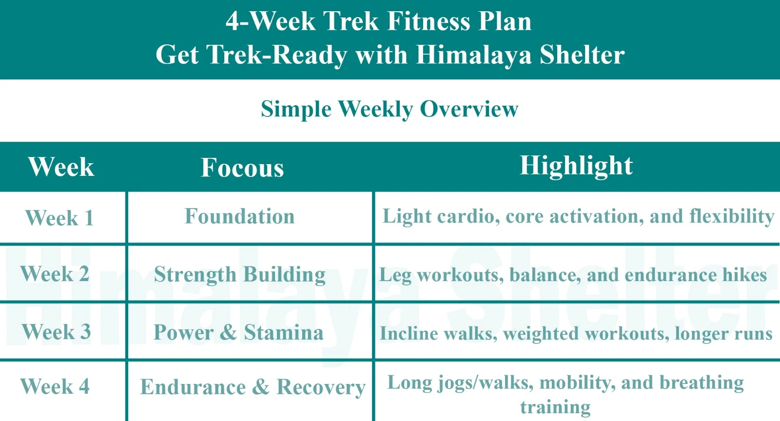
4-Week Trek Fitness Plan - Simple Weekly Overview
|
Week |
Focus |
Highlight |
|
Week 1 |
Foundation |
Light cardio, core activation, and flexibility |
|
Week 2 |
Strength Building |
Leg workouts, balance, and endurance hikes |
|
Week 3 |
Power & Stamina |
Incline walks, weighted workouts, longer runs |
|
Week 4 |
Endurance & Recovery |
Long jogs/walks, mobility, and breathing training |
Foundation
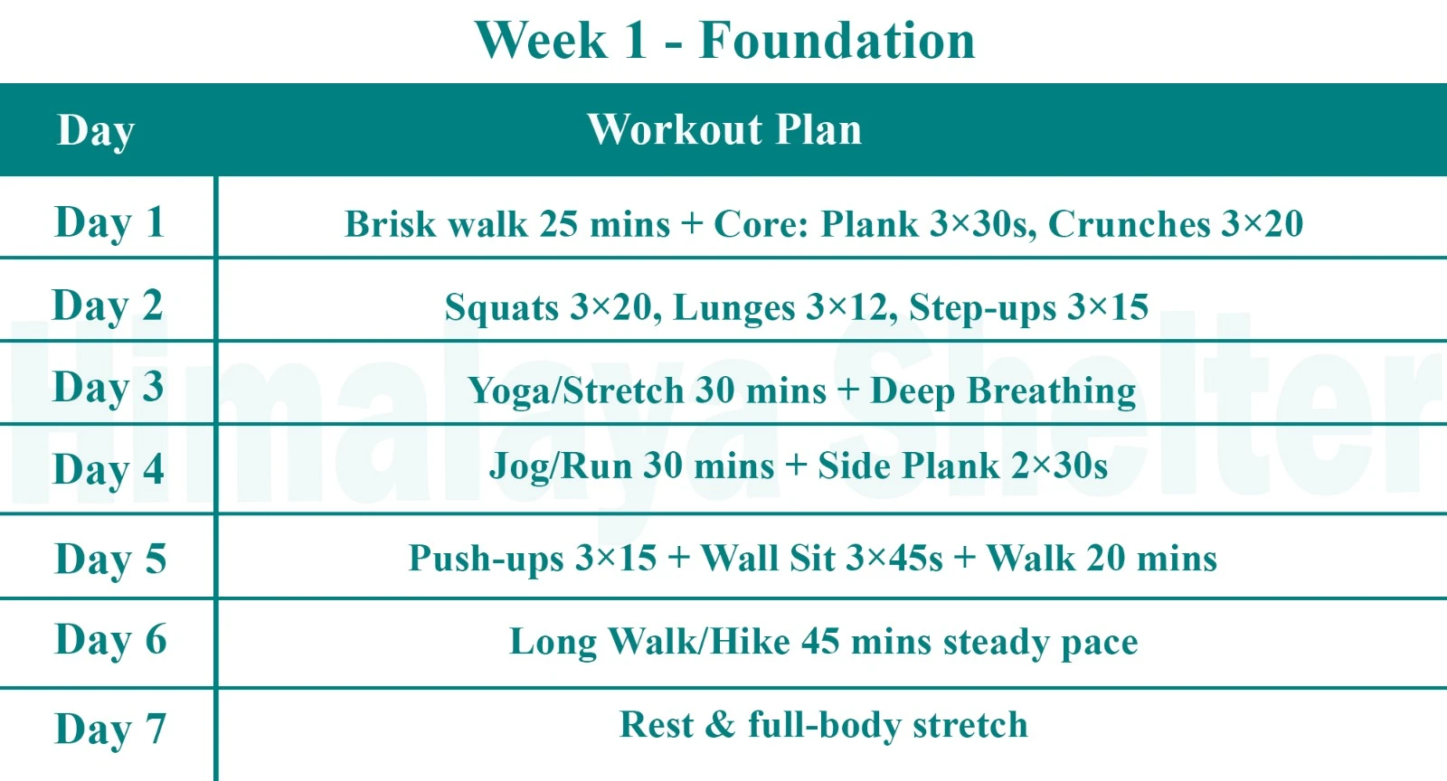
Week 1 - Foundation
|
Day |
Workout Plan |
|
Day 1 |
Brisk walk 25 mins + Core: Plank 3×30s, Crunches 3×20 |
|
Day 2 |
Squats 3×20, Lunges 3×12, Step-ups 3×15 |
|
Day 3 |
Yoga/Stretch 30 mins + Deep Breathing |
|
Day 4 |
Jog/Run 30 mins + Side Plank 2×30s |
|
Day 5 |
Push-ups 3×15 + Wall Sit 3×45s + Walk 20 mins |
|
Day 6 |
Long Walk/Hike 45 mins steady pace |
|
Day 7 |
Rest & full-body stretch |
Strength Building
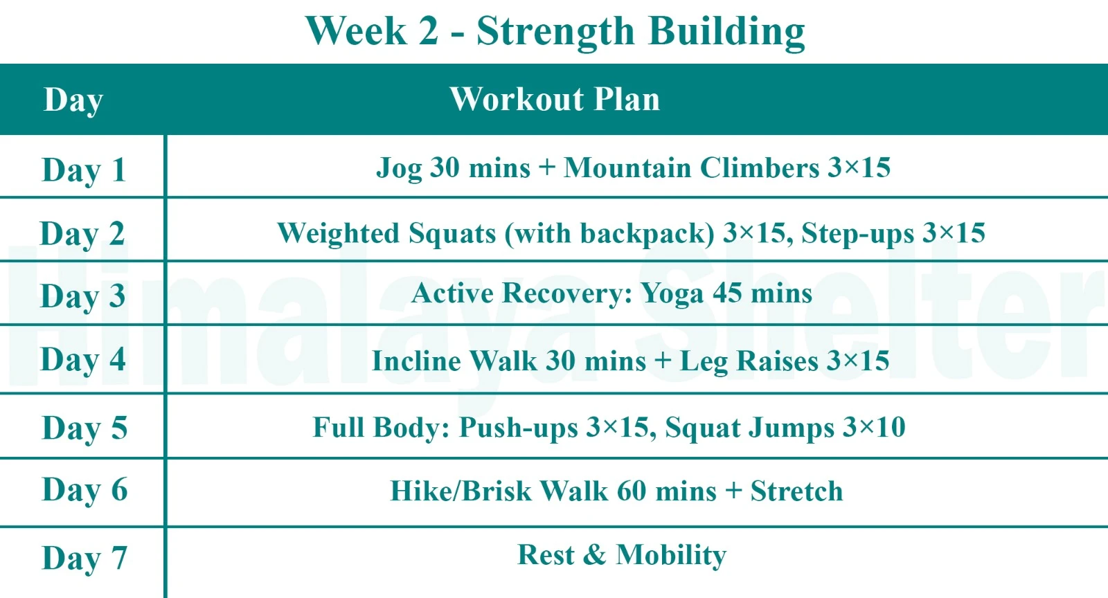
Week 2 - Strength Building
|
Day |
Workout Plan |
|
Day 1 |
Jog 30 mins + Mountain Climbers 3×15 |
|
Day 2 |
Weighted Squats (with backpack) 3×15, Step-ups 3×15 |
|
Day 3 |
Active Recovery: Yoga 45 mins |
|
Day 4 |
Incline Walk 30 mins + Leg Raises 3×15 |
|
Day 5 |
Full Body: Push-ups 3×15, Squat Jumps 3×10 |
|
Day 6 |
Hike/Brisk Walk 60 mins + Stretch |
|
Day 7 |
Rest & Mobility |

Power & Stamina
Week 3 – Power & Stamina
|
Day |
Workout Plan |
|
Day 1 |
Run 35 mins + Core Circuit (Plank, Crunch, Twist) |
|
Day 2 |
Hill Sprints / Stairs 20 mins + Lunges 3×12 |
|
Day 3 |
Yoga + Flexibility 40 mins |
|
Day 4 |
Incline Trek Simulation (with backpack) 30 mins |
|
Day 5 |
Burpees 3×10 + Push-ups + Step-ups |
|
Day 6 |
Long Cardio: 60–75 mins walk/jog |
|
Day 7 |
Full Rest + Meditation |
Endurance and Recovery
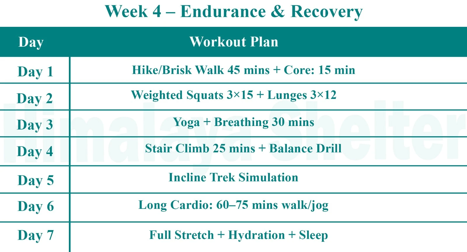
Week 4 – Endurance & Recovery
|
Day |
Workout Plan |
|
Day 1 |
Hike/Brisk Walk 45 mins + Core: 15 min |
|
Day 2 |
Weighted Squats 3×15 + Lunges 3×12 |
|
Day 3 |
Yoga + Breathing 30 mins |
|
Day 4 |
Stair Climb 25 mins + Balance Drill |
|
Day 5 |
Incline Trek Simulation |
|
Day 6 |
Long Cardio: 60–75 mins walk/jog |
|
Day 7 |
Full Stretch + Hydration + Sleep |
Additional Tips:
- Consistency & Form: Maintain proper technique and gradually increase intensity.
- Recovery & Flexibility: Allow muscle recovery, and stretch before and after workouts.
- Balance Training: Incorporate strength exercises like deadlifts for overall balance and endurance.
Regularly performing these exercises will build the necessary strength and stamina for a successful trekking experience. Good fitness is crucial for tackling the challenges of the Bali pass summit and fully appreciating the adventure it offers.
Safety Precautions & Protocols during the Bali Pass Trekking
The challenging terrain requires careful planning and adherence to safety precautions to ensure a safe and enjoyable trekking experience. Here is a list of 11 essential safety precautions and protocols for the Bali pass:
-
Acclimatization:
- Importance: Acclimatization helps stabilize oxygen levels in the body. It is crucial for preventing altitude sickness and maintaining physical fitness.
- Protocol:
- Spend an extra day at the Bali pass base camp or intermediate points to adjust to the altitude (if required).
-
Ascend gradually, avoid ascending too quickly.
-
Climb high and sleep low. After reaching the campsite, hike to a higher elevation than the campsite's altitude, spend some time there, and then return to the campsite.
-
Reduce strength exercises and increase yoga practice with Pranayama or other slow breathing techniques.
-
Weather Preparedness:
- Importance: The weather during the Bali pass can be unpredictable, with sudden rainfall and variation in temperature. Knowing weather facts helps trekkers determine the best time to start or not start their trek, and be prepared for any expected weather fluctuations during the hiking.
- Protocol:
-
Check weather forecasts regularly.
-
Be prepared for sudden changes by carrying appropriate gear, such as waterproof jackets or a poncho, warm fleece, and extra pairs of quick-dry socks.
-
In the mountains, afternoon rain is more common than other times of the day. So, make sure to start and end your hike before noon.If it’s raining continuously, pause on the hike on the spot but avoid stopping near water streams and narrow valleys. Try to pass away these areas as quickly as possible.
-
-
Hydration and Nutrition:
- Importance: Staying hydrated and well-nourished helps maintain energy and health
- Protocol:
-
Drink plenty of water at regular intervals throughout the trek.
-
Carry high-energy, easy-to-digest foods like nuts, energy bars, and fruits.
-
Avoid taking alcohol.
-
Avoid consuming sugary foods or drinks during the trek. Excess sugar increases blood glucose concentration, leading to fatigue.
-
-
Health and First Aid:
- Importance: Immediate response to health issues can prevent serious complications.
- Protocol:
-
Carry a comprehensive first aid kit, including altitude sickness medication, and be familiar with basic first aid procedures.
-
Inform your trek leader of any pre-existing health conditions.
-
-
Safety Gear:
- Importance: The right gear can prevent injuries and keep you safe in adverse conditions.
- Protocol:
-
Wear sturdy, broken-in trekking boots with good ankle support.
-
Dress in layers to manage your body temperature.
-
Carry a reliable backpack with a rain cover and other essentials such as a headlamp, rope, oxygen cylinder, gaiters, and microspikes.
-
-
Emergency Preparedness:
- Importance: Quick action is vital in emergencies
- Protocol:
-
The nearest hospital is located in Dewal Block, which is nearly 28 km from the Bali pass base camp.
-
Keep emergency contact numbers.
-
Ensure that your trek leader has communication devices such as a satellite phone or walkie-talkie in case of an emergency. Also, whenever you get a mobile network, keep updated the basecamp or your emergency contact person.
-
Make sure you have appropriate adventure insurance that covers trekking in high-altitude areas.
-
-
Navigation and Trail Safety:
- Importance:Navigating high altitudes and challenging trails requires caution and skill.
- Protocol:
-
Follow your guide.
-
Follow marked trails and use a compass, maps, or GPS devices to avoid getting lost on the trail.
-
Pay attention to trail markers and avoid venturing off the path.
-
-
Wildlife Awareness:
- Importance: Encounters with wildlife can be a risk
- Protocol:
-
Maintain a safe distance from animals.
-
Avoid leaving food unattended and keep your campsite clean to avoid attracting wildlife.
-
-
Group Coordination:
- Importance: Staying connected with your group ensures collective safety
- Protocol:
-
Maintain regular communication with your group.
-
Follow the trek leader’s instructions and avoid separating from the group.
-
-
Environmental Responsibility:
- Importance: Protecting the natural environment is essential.
- Protocol:
-
Follow "Leave No Trace" principles.
-
Dispose of waste properly and avoid disturbing wildlife or vegetation.
-
-
Altitude Sickness Awareness:
- Symptoms: Headache, nausea, dizziness, and shortness of breath.
- Protocol:
-
If symptoms occur, inform your trek leader immediately.
-
Descend to a lower altitude if necessary and seek medical help if symptoms persist.
-
On the Bali pass trekking, there are less chances of altitude related sicknessess. Also, you ascent gradually each day of hiking which helps you to be fully acclimitazation. Still, if any symtoms occurs, keep your walking pace slow and steady untill you reach back to the basecamp or a lower altitude campsite.
-
Adhering to these safety precautions and protocols will help ensure a safe and memorable experience on the Bali pass. Proper preparation and awareness are key to navigating the challenges of this beautiful Himalayan adventure.
Your Comfortable Stay at Sankri: Himalaya Shelter Guest House
It is always better to stay in Sankri for at least one night before starting the trek, as it helps your body adjust to the altitude. On reaching Sankri, you will stay at the Himalaya Shelter Guest House, which offers a comfortable and peaceful stay for trekkers. The rooms are spacious, clean, and come with attached washrooms and hot water facilities for extra comfort after a long journey.
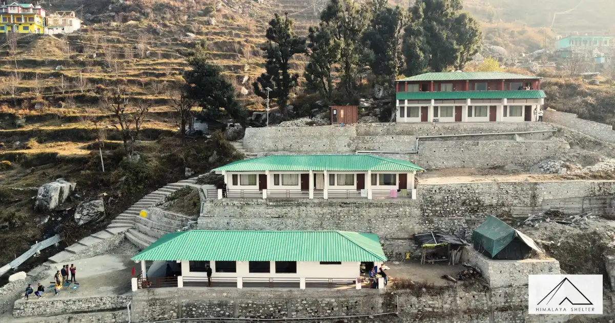
You can relax on the balcony and enjoy beautiful sunset views over the Himalayas. Watching the sun go down behind the mountains is truly a special experience. Fresh, hygienic, and tasty food is served at the guest house, and if informed earlier, you can also enjoy a traditional Garhwali Thali.
With its peaceful surroundings, mountain views, comfortable rooms, good food, and warm hospitality, Himalaya Shelter Guest House is loved by trekkers, travellers, and even people looking for a calm work-from-the-mountain stay.
Customize Your Bali Pass Trek with Himalaya Shelter(HS)
In Himalaya Shelter, we provide you with the option to customize your trekking experience. Whether you're a solo traveler, a group of friends, or a family, you can opt for our personalized tailor-made trekking program. This customized trek will be exclusively designed for you, taking into account your specific requirements for transportation, accommodation, meals, and any other premium facilities you may need during the trek. No other participants will be added to your group. Choosing a customized trek will enable you to fully enjoy the trek with your loved ones. Click here to learn what a Customized Trekking program looks like.
Please read our Cancellation Policy before booking Bali Pass Trek.
Why choose Himalaya Shelter For Your Bali Pass Trek?
Mountain-centric & Local Roots
Started by a trekker born in the Himalayas (Bachan Rana), most of their team are locals. That means real terrain knowledge and instincts on the trail.
We operate in regions like Uttarakhand, Himachal Pradesh, Kashmir & Ladakh — strong ground support matters at altitude.
Safety Above All
- Certified trek leaders trained in CPR & first aid
- Zero fatality record for over a decade
- Daily health checks and acclimatisation focus
- Oxygen support if needed
These aren’t just promises — these are real safety systems, not just marketing words.
Small & Personal Groups
Most big companies run 20–30+ people. Himalaya Shelter usually keeps groups small (8–12) — so guides can care about you, not just the batch.
Small groups = better experience | More attention | Better bonding | Less chaos | Faster response if something goes sideways
Flexible & Fair Policies
If bad weather or health stops you from finishing, we let you rejoin the same trek later without extra fees — that’s rare.
Food & Comfort That People Talk About
Many trekkers specifically praise the meals, tents, and service — not something every operator manages well at high altitude.
Customised Treks
We tailor your trek based on your:
- Fitness level
- Group type
- Preferred pace or dates
- Select your cuisine
Real customisation is not standard everywhere.
Responsible & Eco-Friendly Trekking
We follow responsible trekking practices to minimise environmental impact and respect local communities. Supporting local staff and village economies is a core part of our philosophy.
In short, Himalaya Shelter feels less like a company and more like a mountain family — deeply rooted in the Himalayas and committed to making your trek safe, personal, and memorable.
Inclusions & Exclusions
Trek Package Inclusions
Our treks are specially designed by the experienced team at Himalaya Shelter, taking you on an adventure of a lifetime all while making you connect not only with the bountiful nature but also with yourself and with others on the trek with you creating wonderful memories which will last you a lifetime. All Himalaya Shelter treks are guided by experienced Trekkers having vast knowledge and experience of the region, providing with insightful information and stories pertaining to the region’s flora and fauna and the history of the region whilst the trek. It is safe to say that on successfully completing the trek, one will gain tremendous insight and experience along with lifetime memories.
- Transportation – Day 1: Driver from Dehradun to Sankri. Pickup time: 7:30 am, Prince Chowk, near Dehradun Railway Station
- Accommodation – At Base Camp, stay at a local homestay or guest house for one night each, which will give you an insight into the authentic lifestyle of the locals.
- On Trek stay in a 2-person Vango Halo Pro/A-Shape tent, which is to be shared by two trekkers, built to withstand extreme weather conditions and at the same time making you comfortable after a hard day’s trek.
- Camping Equipment – specially designed sleeping bags that can withstand harsh weather conditions, foam mattresses. Other safety gear like microspikes, gaiters, an ice axe, and helmets will be provided.
- Medical Kit – our team will be equipped with an extensive medical kit, which our team is trained and experienced to use. Oxygen cylinders are used after they are thoroughly inspected throughout the Trek. Even campsites have large oxygen cylinders as backups.
- Permission - Forest entry charges for Indian nationals (Additional charges will be applicable for international tourists)
- Meals – Breakfast, packed lunch (on trek days), evening snacks, and dinner will be served. A hearty, delicious, and nutrition-filled Veg meals with egg preparation will be provided throughout the trek. (Jain and Vegan Food can also be arranged on prior notification.)There will be a dedicated Kitchen Tent along with a dining tent, which will have a dining table too.
- Our Team – A highly experienced and AMC-certified Trek Leader who will help ensure that the entire trek goes smoothly and safely while navigating the challenging conditions during the trek, and is skilled enough to navigate any medical emergency that can arise during the trek. Local and route Guides who are well-versed with the region and provide an in-depth insight into the local customs and knowledge of the flora and fauna endemic to the region. A dedicated Kitchen staff, which includes a Cook, a helper, and other support staff. There will also be porters and mules to carry common equipment.
- CLOAKROOM - We have a cloakroom facility available for extra luggage. Every trekker is permitted to leave their luggage behind at no charge.
Exclusions
- Personal expenses like tips, personal medicines, phone calls etc.
- Travel Expenses - Travel expenses from your hometown to the mentioned Pick-Up Point are not included in the trek fee.
- From the scheduled pick-up spot to the base camp, we have our own fleet of vehicles like Bolero, Innova, Dezire, or Tempo Traveler (12-seater). This is be shared by trekkers for a pre-decided amount. All vehicles are non-AC.
- Personal Equipment - Any personal gear like jackets, shoes, cutlery, or backpacks are not included in the trek fee. We recommend renting them from our Rental Store for an affordable fee. This can be pre-arranged to avoid last-minute hang-ups.
- Offloading - We encourage carrying your backpack to get into the true spirit of trekking. However, if needed, you can opt to offload your personal luggage of up to 12 kgs for an additional cost of INR 500 per bag per day.
- Trek Insurance - A mandatory trek insurance fee is charged in addition to your trek fee. Since most medical insurance doesn’t cover adventure activities, trek insurance offers essential coverage, enhancing your safety without a significant financial burden.
- Buffer day on the trek - We have kept a buffer day on the trek to account for any weather-related delay. If this is utilized, you will need to pay an extra amount to your trek leader.
- Anything apart from inclusions
- Please carry a lunch box for a packed lunch/breakfast to avoid using polythene and Aluminium foil.
Keeping the Himalayas clean is our own responsibility. Reduce the use of Plastic when you are in the abode of the Sacred Himalaya. 🌱
Videos
!
Exceting Videos coming Soon
We’re currently working on putting together all the details for this trek 🎥 Stay tuned, exciting videos covering everything you need to know will be coming your way very soon!
More treks like Bali Pass Trek
Customer Reviews

Samwise Patterson
5.0
We had an awesome experience with the entire Himalayan Shelter team! Our guides were Bachan rana, and Ramesh sajwan and they both an amazing job taking care of us. They knew the trails very well, they took care of our needs at camp like food and shelter and ensured our safety during the entirety of the journey. If you get the chance, please take this adventure with the Himalayan Shelter team!

Izzy Bernbaum
5.0
Some of the nicest guides and best views you could imagine highly recommend.

Gordon Gogulski
5.0
Best experience ever, very caring and make the best food. Highly recommend.

Paige Alcorn
5.0
absolutely beautiful hike and the guides were amazing, open to answering questions and making the whole trip!!

Reema Kuwar
5.0
I recently trekked to Kedarkantha with Himalayan shelter. I would like to appreciate the whole team, for their cooperation, patience and making the submit a success. Special thanks to Nitin, Sonu and Arjun, to make sure, everyone took part in the trek, and for their genuine help to all the trekkers. The food was fabulous as well. Thanks for your, help and guidance team.

Ankit Kundra
5.0
Himalaya Shelter is an excellent trekking company. The staff was extremely cooperative, and the rooms were clean and hygienic. The food was outstanding — easily 5 stars. Our trek leader, Saurabh, was highly experienced and continuously guided, motivated, and supported us throughout the trek. The Kedarkantha trek itself was an unforgettable, once-in-a-lifetime experience that gave us a bag full of memories and valuable life lessons. If you’re looking for a reliable and well-organized trekking company, Himalaya Shelter is a great choice.


Archish Vasu
5.0
Recently I had an amazing experience on the Kedarkantha Winter Trek with Himalayan Shelter, and a big part of that was thanks to Tanisha Chauhan our trek lead. From the very beginning, she was extremely helpful, professional, and supportive. She guided us clearly with all the trek details, preparations, and logistics, which made the entire journey smooth and stress-free. During the trek, her coordination and constant encouragement really stood out, especially in the challenging winter conditions. Tanisha’s positive attitude, dedication, and care for every trekker made this experience truly memorable. I’m very grateful to her and highly recommend Himalayan Shelter—and especially Tanisha—for anyone planning a Himalayan trek.


Manish Kukreja
5.0
Yes, ~12,000 ft / ~3,600 m! We did it with the exceptional team at Himalaya Shelter. We are a family of four with two boys (11 and 12 years old), and this was our first Himalayan trek at Dayara Bugyal. We were picked up from Dehradun Airport and driven to Uttarkashi, where we stayed for a night. The next day, we drove to Raithal and started our trek to the Gui campsite, spending the night in alpine tents at freezing temperatures of -1°C. On the second day, we walked about 8 hours in total and scaled the highest point of Dayara Bugyal (~12,000 ft). That evening, our cook, Subhash ji, presented us with a surprise cake during dinner to celebrate the moment. The night was even colder at -4°C, and the peaks saw some snowfall. On the third day, we descended to Raithal and drove back to Uttarkashi for the night. On the final day, Bim (Sasi) and the Himalaya Shelter team dropped us off in Rishikesh to continue our adventures in Dev Bhoomi, Uttarakhand. We would like to thank the entire Himalaya Shelter team: Bachan ji and Tushar for booking and operational assistance; Tanisha, our trek leader, for guiding us and being patient and encouraging with our children; Sonu for providing overall guidance, care, and sharing his experience throughout the journey; and Subhash ji for the amazing, thoughtful, and yummy food, as well as accommodating our requests. Finally, not to forget Bim (Sasi)—a safe pair of hands behind the wheel who made the whole trip safe and comfortable. Thank you! We hope to continue this relationship with another adventure—maybe Har Ki Dun?!

Devanand Jethanandani
5.0
It was very wonderful trekking experience of Ancha Trek we had with Himalay Shelter.. Very delicious food we enjoyed on the entire trip and thanks to the cook Bijay Singh Overall experience was memorable one.

Jitendra Teelani
5.0
We completed the Ancha Top trek with Himalayan Shelter, and overall it was a great experience. The arrangements were well managed and the service was amazing. A special mention for the food — it was truly awesome, which made the trek even more enjoyable in such cold conditions. Huge thanks to Vijay (MAMA) for the delicious food and warm hospitality 🙏 — it really felt like home on the mountains. However, we would like to share one concern. We were a group of 8 people, and unfortunately, we felt that the guide Mukesh was mostly involved with one foreigner guest, due to which our group was often left on its own. This affected our overall experience and group coordination. We hope Himalayan Shelter will look into this and ensure equal attention and support to all trekkers in a group. Overall, a memorable trek with great food and service, with scope for improvement in guiding support.

Alpeshbhai Kachhadiya
5.0
GOOD SERVICE COOK IS VERY GOOD "BIJAY SINGH" HIS COOKING IS VERY DELICIOUS HIMALAYA SHELTER GROUP MANAGEMENT IS TOO GOOD WITH CUSTOMER WE FEEL LIKE FAMILY PERSON

Mehul Patel
5.0
Food was so good. Special thanks to Mr. Bijay singh Hospitality and all arrangements also very good Ancha Top trek


Sourabh Unnikrishnan
5.0
Had a fantastic time with the team during my Dodital trek and Aancha top trek. Their warmth, care and expertise gave no room for discomfort at anytime. It was a great get away with friends while seeing each other a little outside our comfort zones. Highly recommended!

Anagha Ghorpadkar
5.0
We had a fantastic trek with Himalayan Shelter in dec 2025. We were a group of 14 people. Right from the time we reached Dehradun and until our drop back to Rishikesh, the entire journey was very well arranged. Timely pick up, comfortable road trip in a TT to Raithal, trek preparations, the lovely Pahadi food, comfortable stay at Raithal was just awesome. Through the trek, Mr Bachan Rana and Mr. Abhimanyu were very enthusiastic and encouraging. Rocky was a hero for us- always with a smile and serving us yumm food. The kids loved him as he gave them super maggi 😊. Anything we asked Rocky said - “ho Jayega” which put all our questions to rest. Our first Himalayan trek and it was made memorable with Himalayan Shelters. They made it comfortable as home in the Himalayas 😊. Looking forward to more adventures with them.

Sanwar mal Yadav
5.0
Had an amazing experience doing the Aancha Top trek with Himalayan Shelter. The team was professional, well-organized, and super supportive throughout the journey. Great stay, tasty food, and breathtaking views! Highly recommended for anyone planning a Himalayan trek.

Vaishali Bathvar
5.0
Amazing place, view and special thanks for the co-operative staff #mr.Nitin#mr.Ramesh our treker they gave us best treking experience and they are too polite persons , and hotel staff they gave best hospitalise #mr.subhas#mr.sooraj raja # mr. goldi Specially recommend this place plz visit and enjoy your trek.😊 Rooms are better also☺️

Ashmita Chatterjee
5.0
I have been travelling with Himalayan Shelter for two years now, and it has been an absolutely wonderful experience. The guides are extremely knowledgeable, talented, and responsible. They were also very generous and supportive throughout the trek, always ready to help and motivate everyone. Thanks to their excellent planning, guidance, and constant encouragement, the trek never felt exhausting at all. Safety, comfort, and group morale were clearly their top priorities. I felt well taken care of at every step.

Iftiker Alom
5.0
This trek turned out to be completely unexpected in the best possible way. Although everything was unplanned, the entire journey unfolded beautifully and was full of pleasant surprises. Bachan Da’s storytelling and the way he shared his experiences throughout the trek made the journey truly special, it was engaging, warm, and memorable. The homestay arrangements were excellent comfortable, welcoming, and well managed. The service provided throughout the trek was outstanding, and the care and support from both Bachan Da and Rocky Da were genuinely exceptional. Their company made the trek even more enjoyable and reassuring. The summit was breathtakingly beautiful and absolutely worth the effort. Both the journey and the destination were remarkably scenic and enriching. Overall, it was an unforgettable experience, and I would highly recommend trekking with them to anyone looking for a meaningful and well guided adventure.

Lavish Thakurgota
5.0
Best trekking company special HARSH bhai you are best and very gentle person. Supported everyone in the group.

Manuraj Tomar
5.0
Went solo, came back with amazing memories and new friends 🤍 Thanks to everyone for making this trek special—and special thanks to Nitin and Tanisha for taking such great care of us!

Nitin
5.0
Everyone along the journey were very kind and hospitable, it was my first trek and they made sure it's a memorable one!

Rajashree Joshi
5.0
Just completed a trek to Dayara Bugyal with HimalayaShelter. We had a wonderful experience thanks to the team. Not only were the arrangements top-notch, but their flexibility with our plan changes, genuine warmth, encouragement, and of course, the yummy hot food served lovingly made it all the more special. Highly recommend Himalaya Shelter.

Shashishekhar Chaugule
5.0
Trust Bachchan and his team at Himalaya Shelter for a well-organized, comfortable trek. We did Dayara Bugiyal with them in December 2025 and would surely love to come back for more.

Vineet Dravid
5.0
We trekked with Himalaya Shelter in Dec '25. The entire trek was excellently organised. Attention to detail was commendable and every possibility was accounted for by the team. The entire team was committed and worked from 4 to 10 to ensure the trek was incident free and pleasurable. Special mention to their commitment to the environment. They minimised waste and there was no plastic throughout the trek. Highly recommended!

Koustav9
5.0
It was a great trek❤️❤️ The behaviour and the familiarity they have the shown in the entire tour was amazing. Looking forward to some more adventures with this group😊😊

ratnesh pandey
5.0
We organized our team offsite for 23 member team through Himalayan Shelter, and the experience was absolutely outstanding. From start to finish, everything was managed with great care and attention to detail. Tushar and Bachan added thoughtful personal touches throughout the journey, ensuring that every small requirement was taken care of during our trek from Chopta to Chandrashila. Our CEO and CTO joined us from the US, and they thoroughly enjoyed every bit of the experience, which speaks volumes about the quality of planning and execution. The food and accommodation were extremely hygienic, comfortable, and well-organized, and the transportation arranged for the team was smooth and top-notch. Overall, Himalayan Shelter went above and beyond to make our offsite memorable, seamless, and truly enjoyable. Highly recommended for anyone looking to plan a well-curated and hassle-free trekking or team offsite experience in the Himalayas.

Vishal Reddy
5.0
Had a wonderful experience at Kedarkantha. The trek was beautifully organized, and the entire journey was smooth and memorable. A special mention to our guide Tirupan Rana — extremely knowledgeable, calm, supportive, and always motivating throughout the trek. He ensured everyone felt safe, comfortable, and confident, especially during challenging sections. His local insights and positive attitude truly enhanced the overall experience. The arrangements, food, and campsite management were well taken care of, making the trek enjoyable even in tough weather conditions. The only minor drawback was the unavailability of hot water for bathing, which was manageable considering the terrain and weather. Overall, a fantastic experience and highly recommended — especially with a guide like Tirupan Rana, who made the trek even more special.

skarate academy
5.0
Good trekking experience Food was good and Trek leader trepan bhai was good and explained well and took good care of us

Syed Saif Ali
5.0
"5/5 ⭐️ Amazing experience with Himalaya Shelter! 🔥 From transport to tents, food to guides – they took care of everything! 😍 The trek leader was super supportive and knowledgeable, made the Kedarkantha trek a breeze 💪. Food was delicious and hot, even in the freezing cold 🍲❤️. Hospitality was top-notch, felt like home 🏡. Highly recommend for a hassle-free, memorable trek! 👏"

lalu prasad
5.0
My Kedarkantha trek with Himalayan Shelter was a wonderful experience. The team was supportive specially my tracking guide (Mr. Tripan Rana) and our driver (Mr. Mahesh Singh Rawat), well-trained, and very professional. Everything was well managed, and I felt safe and comfortable throughout the trek. Highly recommended for anyone looking for a memorable trekking experience.

Ronak Nahata
5.0
Classic trek… Our guide nitin bhaiya and tanisha dii is veryy good and helpfull And the food iss very tasty Just classic people Thank you for giving us wonderfull trek..😇


TANMAY
5.0
I went on Kedarkantha trek with my friends on 7th Dec 2025 through Himalaya Shelter, and it was one of the best trek experience I had. The guides Saurabh sir and Nithin Sir were super friendly and supportive. The food was just amazing and the whole organizing was done perfectly.

Sanjay Gupta
5.0
It was an amazing experience with hemalyanshelter. We went of Kedarkantha trek with them the provided good food and snacks. I appreciate the efforts of cook and trek leader.

Suresh Dhulipala
5.0
I have been waiting to trek in Himalayas for a very long time and Aancha Top Trek is my first trek in the region and with Himalaya Shelter. My experience is really wonderful with breathtaking sceneries in the Himalayas wilderness as well as with the Himalaya Shelters team. We were the first batch of Aancha Top Trek as its newly added trek with no crowd at all on the trek, team has executed it very well. Bachan Rana ji also accompanied with the team for this trek along with the guide Mr. Saurav. We had very enlightened long discussions about other treks, local cultures and the traditions of the region. We had yummy food throughout the trek and I really loved the evening soup. Bachan ji and his team is very professional and I am really happy that I chose them for my forst every trek and looking forward for other treks in the near future. Thank you so much for your time and dedication team 🙏

aseem goyal
5.0
Second trek with Himalaya Shelter, and they still managed to blow me away! After a fantastic experience at Kedarkantha last January, I didn’t hesitate to book with Himalaya Shelter again for a trek to Aancha Top (3800m) near Ranachatti. As a local Uttarakhand business, they bring an authenticity and professionalism that is hard to find elsewhere. What makes them stand out is their flexibility and the "little" details that aren't so little when you're at high altitude. Case in point: freshly made Gulab Jamun served at 3800m! There were no restrictions on quantity, and the entire menu was consistently great. A huge shoutout to our guide, Mr. Saurav, and the kitchen/support staff who were incredibly helpful throughout. We were also joined by the founder, Mr. Rana, as this was their inaugural trek to Aancha Top. Getting to know him was a highlight; he is a wonderful person who is genuinely open to feedback and new ideas to improve the hiker's experience. If you are looking for a professional, flexible, and warm trekking partner in the Himalayas, look no further. I’m already planning my third trip with them. Thank you, Himalaya Shelter!


Sidhesh Narse
5.0
Aancha Top Track 🥶it was a awsome track and we were the 1st Goans to complete this track Himalyan Shelter mark the name in your mind guys they are the Best ever company to track with very experienced polite knowledgable most important "Real" will surely plan our nxt track with Himalaya shelter

VINIT BHATT
5.0
Amazing experience from food to tent stay everything was awesome, our trek leader Nitin Sir and Parvez Sir was too helpful and always stays with the group and our cooks subash and sanju were magical, they cooks delicious food and everyone was cooperative

Ankit Prajapati
5.0
Had greate trek of Kedarkantha with trek leader Nitin sir. Enjoyed a lot. A Memorable first trek of my life.

Harshil Bhatt
5.0
“I had a wonderful trekking experience with The Himalayan Shelter. The trek was very well organized, the trail leaders were knowledgeable and supportive, and safety was clearly a top priority throughout the journey. The food was surprisingly good even in tough conditions, and the campsite arrangements were comfortable and clean. The team was friendly, motivating, and always ready to help, which made the trek enjoyable and memorable. Overall, it was a professionally managed trek and I would definitely recommend The Himalayan Shelter to anyone planning a Himalayan adventure.

Parth Upadhyay
5.0
amazing and refreshing experience with beautiful views nitin sir is perfect for a guide to reach the top food was way better than the expectations

Sumrit Paasha
5.0
An unforgettable adventure with Himalaya Shelter! I recently completed the Dayara Bugyal Trek with Himalaya Shelter, and the experience was absolutely incredible. The entire team was professional, well-organized, and genuinely caring from start to finish. Our guides were knowledgeable and attentive, always prioritizing safety while keeping the journey fun and engaging. The campsites were clean and comfortable, the food was delicious (a huge bonus at high altitude!), and the support staff went above and beyond to make sure everyone felt at ease. Himalaya Shelter truly made this adventure memorable. Highly recommended for anyone planning the Dayara Bugyal Trek or any Himalayan trek!

Charita Negi
5.0
We recently completed the Kedarkantha trek with a group of 8, and the overall experience exceeded expectations. The safety standards were top-notch, with certified trek leaders who managed every situation with real operational maturity. The food was surprisingly tasty and consistently well-organized, which kept our team energized throughout the journey. A special mention to the founder, Mr. Bachan Rana, whose humility and hands-on leadership truly elevate the service quality. Himalaya Shelter delivered a seamless trekking experience backed by strong on-ground execution. Highly recommended for anyone planning a structured and safe Himalayan adventure.

Umesh Kumar
5.0
An Unforgettable Experience! My Kedarkantha trek with Himalaya Shelter was absolutely incredible. From start to finish, everything was perfectly organized. The guides were knowledgeable, supportive, and truly passionate about the mountains, which made the entire journey feel safe and enjoyable. The campsites were scenic and well-maintained, the food was surprisingly delicious for high-altitude conditions, and every small detail was taken care of with professionalism. The team ensured we stayed motivated and comfortable throughout, and their warmth and hospitality made the trek even more memorable. Reaching the Kedarkantha summit at sunrise was a moment I will never forget breathtaking views, fresh snow, and a sense of accomplishment made possible by the amazing Himalaya Shelter crew. Highly recommended to anyone planning the Kedarkantha trek. Himalaya Shelter truly delivers a world class mountain experience!

Bhaskar Majumder
5.0
An unforgettable Kedarkantha experience with Himalaya Shelter! I recently completed the Kedarkantha trek with Himalaya Shelter, and the entire journey was absolutely amazing. The team was extremely professional, well-organized, and truly caring. From the very first briefing to the summit push, everything was handled smoothly. The trek leaders were knowledgeable, always checking on every trekker’s comfort and safety. The support staff cooked fresh, delicious meals even in freezing temperatures, and the campsites were clean, warm, and beautifully located. The quality of tents, sleeping bags, and gears provided was also top-notch. What I loved most was their attention to detail—they maintained a sustainable, eco-friendly approach throughout the trek and made sure everyone felt included and motivated. Thanks to Himalaya Shelter, the Kedarkantha summit felt special, safe, and memorable. Highly recommended for anyone planning their first or next Himalayan trek! 🏔️✨


Carolyn Windler
5.0
I did the Nag Tibba trek with guide Mukesh early December and had a great experience. Coordinating in advance via WhatsApp with the company was super easy. Everything went smoothly, on time, and as described, without any issues. The hike to see the sunrise was lovely. And the absolute highlight was my guide Mukesh — he is SO kind, so knowledgeable, speaks excellent English, and you can tell he just loves the mountains. He treats everyone (from locals to guests) with the most generosity. He picks up trash from others to keep the mountain preserved. He made my experience excellent!

Chinmay joshi
5.0
The overall experience of the trek was outstanding. The guides , Nitin, Arjun and Chetan were extremely helpful throughout the trek.. everything was excellent...the stay, the food, the guidance. One of the best experiences of my life.

Rashee Rohatgi
5.0
Had an amazing trek to the Kunjapuri Devi Temple with Himalaya Shelter. Our departure got delayed and so we hiked after sunset for a huge portion of the trek but Bachan Rama made sure I got to temple and back safely. Greatly appreciated 🙏🏽

Phitchayakon Piemthongkham
5.0
The Kuari pass trek was so amazing. It was such a great experience with this trek. Especially, the staff is so nice and kind. They always take care of the trekker. The food also delicious! If I came to India again, I’ll definitely use this agency again.

Pooja Sinha
5.0
The trek was amazing. The guide was really helpful, light minded, and had a lot of patience. He helped us wherever possible, be it mental upliftment or filling out water bottles. The locals and the host were all so hospitable, friendly and celebrated the tourist's excitement without demeaning it in any way. I loved everything about this trek, from timely food to helping us with bandaids during the trek, evrything was perfect. It was overall a fabulous experience and I am totally looking forward to do it again, with himalayan shelter. Thankyou so much for making my first trekking experience and absolute 10/10

Darshil Shah
5.0
We recently completed the Nag Tibba Trek Trek Dates: 17th–18th November 2025 Organized by: Himalaya Shelter It was an amazing trek and truly one of the best experiences we’ve had. The management, food, guide, and overall support from the entire staff were wonderful. A special thanks and heartfelt appreciation to Tanisha and Mahesh bhai for managing the entire trip so smoothly. 🙌🏔️✨ This was my second experience with Himalaya Shelter, and now I truly feel that “Trekking to Bachan Rana (Himalaya Shelter) sathe j karvu” The trust, management, and overall vibe make every trek unforgettable. 🏔️✨

suresh nair
5.0
We had the opportunity to do a weeklong trek to Rupin Supin with the Team Himalaya Shelter, and we enjoyed it very much! The team was very supportive during our journey, along with well-planned meals and safe accommodations. Special shoutout to Bachan Rana for managing our trip with so much care; it was much appreciated. Overall, it was a very enjoyable time, highly recommended for everyone!


Dripta Sur
5.0
I went on my first-ever solo trip and choosing Himalaya Shelter for my Har Ki Dun trek turned out to be one of the most transformative experiences of my life. ✨ From day one the team has made sure I was safe and comfortable. Starting my journey from Sankri to the end everything was perfect and I am writing this review being overwhelmed in the best possible way. I can’t believe I’m saying this but I miss each and every food from the trip. Our cook has made some amazing meals for us each day, my trek leader was very knowledgeable and calm and supportive throughout the trek and the best part of the trip was from day one, the team made me feel like a part of a family. The hospitality was absolutely really wonderful and the entire journey was filled with laughter, stories, and self- discovery. Walking through the peaceful valleys and connecting with people from different walks of life reminded me how beautiful life can be when you step out of your comfort zone. Himalaya Shelter didn’t just organise a trek, they gave me memories for a lifetime. ♥️

Ashutosh Ghate
5.0
My wife and I completed the Kedarkantha Trek with Himalaya Shelter in the second week of November 2025, and the overall experience was truly wonderful and satisfying. Even though there were no other participants in our fixed-departure batch, the company neither cancelled our trek nor asked for any additional charges, which we deeply appreciated. Our trek leader, Ms. Tanisha Chauhan, and support staff/cook, Mr. Tirpan, were both extremely helpful. Tanisha accompanied us throughout the trek and patiently guided us across difficult sections, offering support whenever needed. Despite her limited experience, she tried to handle the trek responsibly. Mr. Tirpan is an excellent cook, and we thoroughly enjoyed every meal he prepared—whether it was dal, pakode, pasta, soups, or other dishes. He consistently served hot, delicious food on time, which made the trek even more enjoyable. Overall, the service provided by Himalaya Shelter was exceptional. I would like to thank Mr. Tushar (co-ordinator), Mr. Tirpan, Ms. Tanisha, and the entire Himalaya Shelter team for making our trek a memorable one.

Tushar Dixit
5.0
Exceptional Family Trek Experience with Himalaya Shelter We recently completed the Fachu Kandi trek in Uttarkashi with Himalaya Shelter, and it turned out to be one of our most memorable adventures. Having done family treks across Sikkim for the past five years, we’re used to a well-coordinated team, quality equipment, and a relaxed pace. This was our first trek outside Sikkim – and without our usual crew – so expectations were high. Right from the start, Bachan Rana and his team impressed us with their professionalism and warmth. They were quick to respond, understood exactly what we wanted, and planned the trek as well as our post-trek holiday to perfection. The trek itself was beautifully organised. We began with a night at their Sankri guesthouse, where we met our wonderful support team. Throughout the trek, they went above and beyond to ensure our comfort, safety, and well-being, supported by excellent equipment and thoughtful planning. Special thanks to: * Rajender ji (Orri Mama) and Simran, our trek leads – they truly made the journey extraordinary. Mama’s deep local knowledge, cheerful energy, and unshakeable commitment kept us motivated through every climb, while Simran’s gentle presence, patience, and instinctive care brought balance and calm to the group. Their teamwork ensured we felt safe, cared for, and always in great spirits. * Tirpan, Bablu, and Goldy, the trek’s true backbone – handling everything from cooking to camp setup, logistics, and managing the mules/horses. Their versatility, ever-smiling faces, and delicious food made each campsite feel like home. * Deepak, our driver – patient, reliable, and non-intrusive, ensuring every long drive was smooth and relaxed. All in all, Himalaya Shelter delivered an outstanding experience – professional, personal, and full of heart. This marks the beginning of our adventures with them, and we’ll surely be back soon for the next one.

SAHASTRA RASHMI
5.0
I have been trekking with Himalaya Shelter for over 10 years with multiple groups. The current trek to Phulara Ridge and Pushtara meadows (the trek was to Fachu Kandi Pass but we teaked the itinerary due to heavy snow cover), was 5th trek in a row. Him Shelter has an excellent staff and service. They have provided very flexible, customised treks with very good support and equipment. They are professional and courteous and as per me the best, most reliable trekking company in India. They have been and will remain my go to people for anyt trekking in the future. Note: Photos uploaded are credited to my co-trekker Gaurav Johri. Used with his permission.

Aditya Deshpande
5.0
Himalaya Shelter arranged our Fachu Kandi Pass trek, which was fantastically managed by their team. Mukesh and Tanisha, our guides, along with the entire support crew, were extremely helpful, professional, and caring — ensuring every part of the trek was safe, enjoyable, and truly memorable. Their coordination and attention to detail made the whole experience seamless. The stay at Himalaya Shelter in Sankri was equally impressive. The accommodation is clean, comfortable, and beautifully built considering the challenging mountain terrain. Facilities are well maintained, and the place has a warm, homely vibe — just what you need before and after a long trek. A special mention to Bachchan Rana, who owns the place, and Amit, who manages it with great dedication. Both are incredibly helpful and go out of their way to make guests feel welcome. Overall, an excellent experience — both the trek and the stay. Highly recommended for anyone planning a trek or visit to Sankri!

Palli 5000
5.0
A group of us had a private tour to Kinjapuri. We were driven to the temple. (Thank you Mahesh for your safe driving). We watched the sunrise then were given breakfast. We then started our hike to Neer waterfall. This was a steep climb down however we were well supported by our guides Tanisha, Bachan Rana and Nitin.thank you for looking after us. Definitely worth using this company.

Gaurav Johri
5.0
Till now I have 2 hikes with Himalaya Shelter. Dodi Tall and Fachu kandi pass, excellent arrangement, excellent staff..in short it was amazing experience. Will highly recommend them for helping arranging any hike.

Venkatesh Veeraraghavan
5.0
We were a group of 12 people on the Fachu Kandi Pass Trek. When it comes to trekking, Himalaya Shelters are the best in the business. Safety and comfort of everyone is their priority, resulting in the best trekking experience. Best in class equipments (tents etc), knowledgeable and experienced guides, cook, and helpful support staff who ensure each minor detail is taken care and updated. Stay away from big commercial establishments and embrace Himalayas with Himalaya shelter.

Sumit Negi
5.0
We had a very comfortable and enjoyable trip with Himalayan Shelter. The food was really good and everything was well managed. Special thanks to Mukesh Bhaiya and Simran Di for being such amazing guides and always taking care of us. They made the trip even more memorable. Highly recommend Himalayan Shelter for a safe and fun experience! 🌄

Anna Will
5.0
We had a great trek up Nag Tibba with Mukesh, he was a great guide and we loved the campsite where we played cricket and had delicious food and lots of chai. Deepak was also a very safe on the windy roads to Pantwari. Trek was steep at points, so tiring in the heat but you saw amazing stars ahead of sunrise. Would highly recommend Himalaya Shelter!

Li Wen Toh
5.0
I did the Buran Ghati private trek in September 2025 as a solo traveller with Himalaya Shelter. It was an unforgettable trek with stunning, highly varied landscapes every single day, jaw – dropping views and the opportunity to witness local life, since many shepherds use this route to drive their herds down to the village for winter. Better still, Buran Ghati trek remains a hidden gem and I had all this mostly to myself. A big part of the incredible experience was the Himalaya Shelter trekking team, who was committed to ensuring I was safe, comfortable and enjoying every moment. First of all, I was very lucky to have Bachan Rana himself as my trekking guide. Having grown up in the mountains and founding Himalaya Shelter, Bachan is an excellent conversationalist and experienced trekking guide with so many stories to tell. Meanwhile, the cook, Bablu, provided delicious meals (I still remember the spring rolls!) throughout the trek. He also worked closely with the mule man to do the hard work of pitching the tents, packing up, loading and unloading the mules. The team looked after me really well with high quality equipment – my home for 5 nights was a large North Face tent and a very warm sleeping bag. Finally, Himalaya Shelter was very flexible in customizing my itinerary before and after the trek to my requirements and also helping to book good hotels along the way. Thank you so much Himalaya Shelter for an amazing adventure! I will be back to do another trek…now if I can just decide which one 😊 - Li Wen, Singapore

manu aryan
5.0
It was a really great experience with the Himalayan shelter, top-notch hospitality.

Ranjit Singh
5.0
I did the Nag Tibba trek with my friend, and it was my first trek ever — such an awesome experience! The views were beautiful, the food was super tasty, and the base camp was really nice and comfortable. Our trek leader was very friendly and made the whole journey fun and safe. I totally loved it and would 100% recommend this trek to anyone, especially if it’s your first one! 🏔️✨

Bharat Korlapati
5.0
We were a group of 3 doing our first trek - Bali Pass Trek. 1. Experience while booking the trek was flexible and accommodating. 2. Prep at Sankri (starting point) before the trek could have been better. If there was checklist read out at Sankri we wouldn't have missed packing a couple of important items but somehow we managed 3. Some rental gear not so good but most of the items needed are available 4. Sonu was a knowledgeable guide and pays attention to detail. I found it a bit hard to build rapport with him but it got better as the trek continued. Wish he made us do warm up/cool down every day but otherwise he knew his stuff 5. Sanjay was a great chef. Tasty and hot, hit the spot every time. We looked forward to it at the end of each day's trek 6. Haridev and Goldie were great help and kept our mood up by cracking joke and singing songs.

KALLURI KOUSHIK
5.0
We are a group of 3 and did Bali pass trek. Entire team did a very good job. Trek guide Sonu was efficieq in planing the trek. Everyday Sanjay made amazing food. Rest of the team Hardev, Goldy were very helpful.

Rajkumar reddy
5.0
beautiful experience Sonu is guide who lead us and Sanju bhai cooked best food and Hari Dev and golu bhai helped us.,,

Ravi Shankar
5.0
The Har Ki Dun trek with Himalaya Shelter was pure magic. From the first step to the final descent, everything was beautifully organized — warm food, cozy tents, and the kindest team you could ask for. We even witnessed snowfall, and despite the tough conditions, our trek captain SONU & RANA special thanks to them went above and beyond — making the right calls, keeping us safe, and lifting everyone’s spirits. Their dedication truly made the journey special and the cook’s effort to serve hot, comforting food in freezing conditions spoke volumes of their commitment. This wasn’t just a trek; it was an experience I’ll cherish forever. 💙 Grateful to Himalaya Shelter for making the mountains feel like home 💫 Here’s to many more trails together! ❄️⛰️

Shweta
5.0
Had a great experience trekking to Har ki doon with Himalaya Shelter. Our trek guides Surinder and Simran are trained mountaineers and knew well about the villages and places on the trek route. The camping tents were comfortable and the food was yum every day! Will be trekking again with them :)

Romeo
5.0
It was a wonderful trekking experience with the Himalaya shelter team. Special thanks to surinder and Simran, our trek leaders. Also thanks to Mahesh, Goldie and Sanju for making this trek a memorable experience. The food was wonderful. They really took special care of all of us. Looking forward to trekking with them again

Olivia Kiedaisch
5.0
Amazing trip and such wonderful guides. Thank you so much Tanisa and Nitin 🙏

Adithya Nagaraj
5.0
Had an unforgettable experience trekking with Himalaya Shelter. Big thanks to our fantastic guides Simranji and Nitin Bhaiyya who were super supportive and full of positive energy. The cook and mule team were incredible too, always ahead of us with everything set up by the time we arrived. The food was surprisingly amazing for a mountain trek, and the transport services were smooth despite the tough terrain. And a special shoutout to Simba the dog, our adorable furry companion who made the journey even more special! Thanks to the whole Himalaya Shelter team and Bachan Sir for a well-organized and memorable adventure!

Sampath Aithal
5.0
Fachukandi 5-Day Trek Review The trek with Himalayan Shelter was an incredible experience! The facilities provided were top-notch, and the guides were extremely understanding, always checking in on our health and ensuring we felt comfortable throughout. The food was excellent, and every day brought breathtaking views that made the journey unforgettable. Highly recommended for anyone looking for a well-organized and memorable trek.

Fatema Merchant
5.0
We were a small group of 3 on Buran Ghati Trek and honestly it turned out to be a beautiful experience. Our trek leader Sonu, cook Mr. Suresh, and Mr. Jashpal were really good at what they do and made sure we were well taken care of throughout I’m quite a curious cat, always asking questions, and Sonu was patient- sharing insights about the trek, the trails, and the surroundings. That added so much more meaning to the journey. Their gear was also spot on, which gave us a lot of confidence along the way Karthi and I have done our fair share of treks, but this was Kishore’s very first one. Watching him enjoy it just as much made it even more special All in all, we couldn’t have asked for a better experience and would wholeheartedly recommend Himalayan Shelter if you’re planning a trek Himalayan Shelter, pls call us for your next KGL Batch


Giorgio Jelinek
5.0
From start to finish everything went perfectly — communication, organization, and execution of the trip. The goal was a trek through the Himalayan valleys, combined with learning about nature and the life of local people. All of this was achieved, and on top of that, the food was delicious. Considering the conditions in which it was prepared, it tasted really good. A truly great, well-rounded experience. Thank you!


Badal Singh kshatriya
5.0
Good experience with himalaya shelter... One of the best company in uttarakhand for the trek


Gurneet Kaur
5.0
Absolutely unforgettable experience with Himalaya Shelter! We recently completed our 4N/5D Valley of Flowers trek with Himalaya Shelter, and I couldn't be more impressed. From start to finish, everything was exceptionally well-organized — from the itinerary and accommodation to the food and logistics. The team was also wonderfully flexible, accommodating our needs without any hassle. The team was professional, knowledgeable, and incredibly supportive throughout the journey. They ensured our safety, comfort, and enjoyment every step of the way, allowing us to truly immerse ourselves in the beauty of the Himalayas without any stress. I highly recommend Himalaya Shelter to everyone looking for a well-curated and memorable trekking experience.

karn Vats
5.0
I want to share my recent group trip experience which was amazing with Himalaya Shelter.organised by Mr bachan with his expertise. Overall it was 10/10 for all the parameters a trip and trek needs. Also a shoutout to Mr Sonu the guide for his best guidance and support . I'll recommend Himalaya Shelter if you are planning trip to Uttarakhand.

Nihal Pawar
5.0
Our recent trip with Himalaya Shelter was nothing short of exceptional. From the very beginning at Dehradun to Chamoli district, Ghangaria trek, Valley of Flowers, Badrinath Temple, Rudraprayag, and finally Rishikesh – every single arrangement was planned and executed perfectly. The entire itinerary was thoughtfully designed, with smooth transitions between destinations and excellent hospitality throughout. The guide Mr Somu was extremely knowledgeable, friendly, and supportive, ensuring that we were comfortable and well-informed during the entire journey. Special appreciation to Mr. Bachan, the in-charge of our trip, who personally accompanied us and made the whole experience even more memorable with his guidance and experience. All aspects of the trip – accommodation, food, transport, trekking arrangements, and local guidance – were handled flawlessly. Truly, 10/10 on every parameter. I would highly recommend Himalaya Shelter to anyone planning a trek or trip in Uttarakhand. Their professionalism, warmth, and expertise make them the best choice for exploring the beauty of the Himalayas

Subhojit Saha
5.0
The tour guides were experienced, professional and fun. AME delivered the much more that what's listed in the itinerary so much so, that I am already looking forward to my return and booking another treak with them.food quality is really upmarket.. Thanks sonu vaiya🙏

devendra uniyal
5.0
Himalaya Shelter, the best trekking company in Uttarakhand. Offering expertly guided treks through the breathtaking landscapes of the Himalayas, we cater to both seasoned trekkers and beginners. Enjoy well-planned routes, comfortable accommodations, and delicious meals as you explore lush forests and towering peaks. Choose us for a safe, eco-friendly trekking experience and discover the majestic beauty of Himalayas." Tour operators Thanks for the Himalaya shatter team

Perina Andre
5.0
We were a small group of five people from Greece. Bali pass trek was a challenging trek because Maria, Tzortzina Sofia and Despina had never been trekking at this altitude. Our leader Rana was exeptional because very supporting and very professional taking care of all details. We went up slowly with all safety we needed. The équipement was perfect (North Face Four Seasons) the food as well. All the team was the best we could get and I am in the position to say that because I did many treks in Indian Hymalayas. This trek has been a Life expérience with all kindness and safety that Rana provides. Thank you for this great expérience. Hari Om.

Shreyas Pawar
5.0
The Pin Bhabha Pass Trek in July 2025 was a Beautiful Experience. It was very well organised by the team and the trek leaders Adarsh, Tripan, Jassu and the Kitchen team who made the yummiest food for us in these temperatures. Starting from the base camp, the Stay at the base camp Kafnu was warm and comforting with amazing view of the river. As we started the trek day with tasty breakfast, the weather got better and we completed the day 1 at Mulling. All the Campsites were beautiful, especially the one at Phutsirang. The trek leaders were very supportive on the Summit day when the trekkers needed it the most. We safely summited the Pass and entered into the beautiful Spiti valley with vast landscape and later visited the serene Chandratal lake. All thanks to the team at Himalaya Shelter. Cheers!

Sushmitha R
5.0
I had my first trek experience with these niche group of people in the industry. They pay attention to individual trekkers and provides best services. A big shout out to our trek leaders Aadarsh, Tripan ji, & Jassu bhai for their love, support, & guidance.

R N YADAV Aryan
5.0
Completed Pin bhaba trek with Himalaya Shelter,had a great experience, food and management were better. Guides were too good with trekkers
Gallery
!
Exciting Images coming Soon
We’re currently working on curating the best visuals for this trek. Stay tuned — stunning images will be coming your way very soon!
Read more on Bali Pass Trek
!
Exceting Blogs/Trek Diaries coming Soon
We’re currently working on bringing together insightful blogs for this trek ✍️ Stay tuned, detailed stories, tips, and everything you need to know will be coming your way very soon!
Bali Pass Trek FAQs
!
Frequently Asked Questions Coming Soon
We’re currently working on compiling helpful answers for this trek 💬 Stay tuned, clear guidance, common queries, and everything you need to know will be coming your way very soon!
Available Dates
From
₹22000 $259
per person