Best Places to Visit in Uttarakhand, widely known as Dev Bhoomi (Land of the Gods), is one of India's most culturally and geographically diverse states and lies in the north-central foothills of the Himalaya. The diverse geography of Uttarakhand is one of the prominent reasons for its unique culture, which is centered on devotion and worship in Hinduism. The sacred rivers, ancient pilgrimage towns, forests, mountains, valleys, snow-capped mountains, and mountain culture create an identity that is a combination of spirituality, culture, and nature.
Uttarakhand is divided into the Garhwal and the Kumaon regions. Garhwal is a region of high mountains, whereas Kumaon is a region of more flat land with rivers that flow through it. Most areas of Garhwal and Kumaon are associated with religious significance, while other regions have great natural beauty, wildlife, and ancient towns. In addition, many of the towns serve as gateways to high-elevation Himalayan routes.
Best Places to Visit in Uttarakhand
Best Places to Visit in Uttarakhand
The following paragraphs contain detailed information about the Best Places to Visit in Uttarakhand, best place to go in Uttarakhand, best place of uttarakhand, along with a description of the attractions and their significance.
1. Mussoorie—Queen of Hills
Mussoorie, established as one of the earlier hill stations in Uttarakhand, located at 6,500 feet above the Doon Valley (Dehradun), is an example of British colonial planning, architecture, and institutional development. The town remains largely intact when compared with other hill stations in Uttarakhand and is situated on a ridge with views of both the Himalayan Mountains and plains below.
The surrounding environment offers a great variety of natural features, including forests, waterfalls, and several high points, including Lal Tibba and Gun Hill. When viewed from one of the higher viewpoints during the early hours of the morning or at dusk, the area offers a panoramic view of the entire valley below, as well as various vantage points along the way up to Mussoorie. The climate of the area tends to be moderate and pleasant through most of the year, making it a popular destination for tourists.
The culture of Mussoorie is characterised by its colonial history and its long-established status as a "social center" of the area. The Landour region, which is quieter than the primary town of Mussoorie, is known for its well-maintained heritage (old) homes and bakeries that have been around for many years. Mall Road, located in the town, serves as the commercial center of Mussoorie and is home to numerous shops offering various goods and services, as well as cafés and restaurants, all of which are located in buildings that date back many years and therefore contribute to the charm of Mussoorie.
The following are treks that are located in the nearby region of Mussoorie: Nag Tibba Trek, Lal Tibba Trek, George Everest Peak, and Benog Tibba Trek.
2. Nainital—City of Lakes
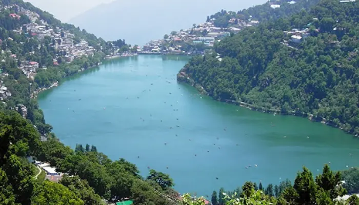
Nainital, which is located in the Kumaon region of Uttarakhand, is a town that was established around the scenic Naini Lake. Due to its location, which is surrounded by forested mountains, the town has a unique appearance from many vantage points because of its enclosed position. The town was established during British colonial administration as a summer holiday destination and retains many characteristics of that era.
Naini Lake is the focal point of the area, and as it is also surrounded by hills and buildings, it will reflect these throughout each day. Areas that will give different views of Naini Lake and the town, such as Snow View Point, Tiffin Top and Naina Peak, are at a higher elevation. Nearby lakes, such as Bhimtal and Sattal, also add to the charm of this area.
Many districts of the city are home to temples and religious sites. The most well-known of these is the Naina Devi temple. Cultural diversity is also present in Nainital, with many old schools, traditional markets and government buildings within the town; thus, Nainital is not only a beautiful place but also contains aspects of culture and history.
The following are treks that are located in the nearby region of Nainital: Naina Peak Trail, Tiffin Top Walk, Kilbury Forest Trail, and Kunjkhara Trek.
3. Rishikesh—Yoga Capital of the World
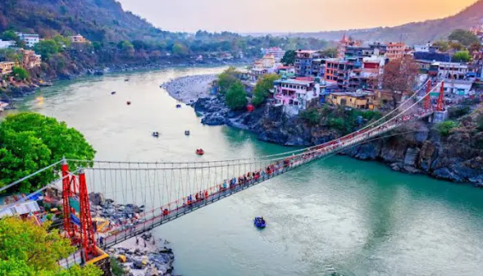
Rishikesh, in the Tehri Garhwal district of Uttarakhand, is on the banks of the Ganga River. It is at the junction where the Ganga River leaves the Himalayas and flows into the plains. Rishikesh's unique geographical location has contributed to its development as a spiritual center throughout history, establishing itself as a major hub for religious study and meditation.
The character of Rishikesh is defined by its river ghats, temples, and various ashrams lining both sides of the Ganga River. Laxman Jhula and Ram Jhula are two of the landmark structures that connect the main parts of Rishikesh. The prayers and rituals performed at the riverfronts play a pivotal role in creating Rishikesh's cultural identity.
In the mid-20th century, Rishikesh became an international destination for yoga and spiritual studies, drawing many practitioners from across the world. This transformation contributed to the establishment of various institutions catering to traditional methods of study, wellness, and simple living, which form the core of life in Rishikesh.
Rishikesh is geographically rich with many opportunities for hiking and trekking, including the following popular trails: Neer Garh Waterfall Trail, Patna Waterfall Trail, and Kunjapuri Temple Trail.
4. Haridwar—Gateway to Lord Vishnu
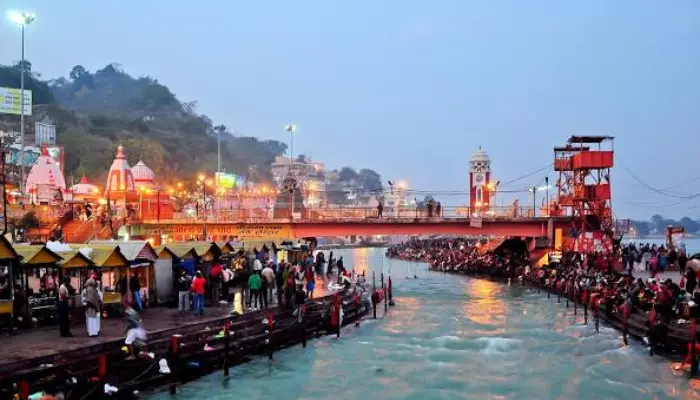
Haridwar is among the most significant pilgrimage destinations in India. Located where the River Ganga arrives from the Himalayan foothills to reach the regions of plains, Haridwar has always acted as both a spiritual and geographical link to the upper Himalayas via the main shrines.
The layout of the city is defined by a series of temple complexes, river ghats and other religious establishments, the most prominent of which is Har Ki Pauri, which is a point where people perform all their daily pujas and ceremonies along the banks of the Ganga. The constant influx of millions of pilgrims provides the city with a continuous pulse throughout the entire year.
Although it is a very busy pilgrimage hub, there are still areas of Haridwar that are relatively peaceful and quiet. Today, Haridwar strives to strike a balance between tradition and modernity, creating a successful blend of spirituality and infrastructure.
The following are treks that are located in the nearby region of Haridwar: Neel Dhara Pakshi Vihar Walks and Chandi Devi Temple Trail.
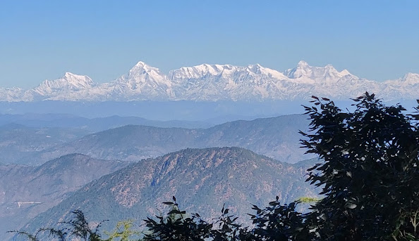
5. Auli—Ski Paradise in the Himalaya
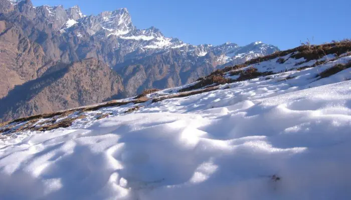
The high-altitude ski destination of Auli in Uttarakhand’s Chamoli District sits at around 9,000-10,500 feet above sea level on its rolling slopes above the valleys below with unobstructed views of Nanda Devi, Mana Parvat, and Hathi Parvat, all very high peaks in the Himalayas. The open slopes of Auli also provide a very alpine-like atmosphere.
The geography of Auli is dominated by snow during the winters, creating a very stark white mountain environment, while the summer brings green valleys, stunning blue skies, and panoramic views of the surrounding mountains, changing the visual experience entirely.
Auli shares a close link with the important year-round town of Joshimath that is located nearby. The local villages of Auli maintain their traditional Garhwali mountain lifestyles as characterised by terraced agriculture, stone homes, and seasonal migration patterns dictated by altitude and climate. Both food habits and daily living practices have adapted to accommodate life at high altitudes.
Unlike other hill stations, there has been little development of urban areas; thus, Auli has retained much of its natural serenity because of the lack of concentrated construction activity and offers an ideal destination for visitors seeking fresh air, abundant open space, and breathtaking, unobstructed views of the mountains.
The following are treks that are located in the nearby region of Auli: Gorson Bugyal, Kuari Pass Trek, and Tali Forest Route
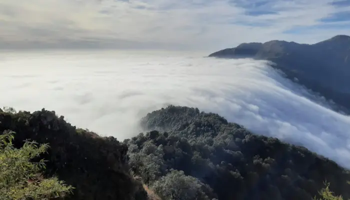
6. Chopta—Mini Switzerland of India
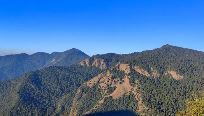
Chopta is situated in Uttarakhand’s Rudraprayag district at elevations ranging from 8,500 to 9,000 feet above sea level, which is quite high compared to other mountain resorts. The majority of Chopta has not been developed heavily, so there are only lower densities of human habitation compared to other developed areas. The meadows surrounding Chopta provide a unique combination of alpine meadows and oak, pine and rhododendron forests, all of which maintain a low density of vegetation, allowing for an open aspect of the landscape.
The environment of Chopta is greatly affected by the four seasons. Winter is known for its severe weather conditions, with planet-wide snowstorms causing deep layers of snow on the landscape that completely cover most of the area. Spring and summer are when meadows become green, and the forest slopes become fully vegetated, giving views of the nearby mountain ranges of the Himalayas.
Chopta’s culture is related to the religious importance of the Garhwal Himalayas. Villages located in and around the area of Chopta maintain and propagate traditional Garhwali practices such as animal husbandry, seasonal migrations of livestock and simple building designs suited to cold climates. Daily life in this region is still very much connected with nature and based on the values of Garhwal’s culture.
The following are treks that are located in the nearby region of Chopta: Chopta Tungnath Trek, Chopta Chandrashila Trek, and Deoria Tal Trek.
6. Valley of Flowers—A UNESCO World Heritage Site
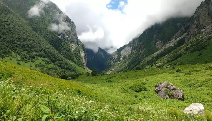
Located in Uttarakhand's Chamoli district, the Valley of Flowers encompasses the upper Himalayan section and is incorporated into the Nanda Devi Biosphere Reserve. The park rises between around 10,500 and 12,500 feet above sea level and protects over 214 species of trees, shrubs, herbaceous plants, as well as a unique alpine ecosystem, through effective management. There are no permanent settlements, as in towns on hills, but restrictions are placed on human activity in order to protect this fragile ecosystem.
Seasonal changes in the valley create dramatic variations in the natural landscape. During the winter months, the valley is completely covered by snow and is not accessible. In the summer, during the monsoon, the snow melts, and rainfall nourishes the growth of many forms of mountain-flowering plants, grasses, and herbs, especially medicinal herbs. The variety of mountain flora creates a distinct mountain ecosystem set against the majestic backdrop of the Himalaya Mountains.
The Valley of Flowers' cultural significance draws strong connections with Hemkund Sahib, an important Sikh pilgrimage location near the Valley. Because of this, the Valley of Flowers incorporates spiritual elements into its cultural background. During the times when trekking into and through the Valley of Flowers is made possible through seasonal settlements, including Ghangaria, visitors may obtain assistance from these settlements. High-altitude Himalayan lifestyles have been greatly affected by the geographical terrain in the valley, along with various weather conditions throughout the year.
The nearby trek routes at the Valley of Flowers are as follows: Hemkund Sahib and Pushpawati Valley Route.
7. Kedarnath—One of the Twelve Jyotirlingas of Lord Shiva
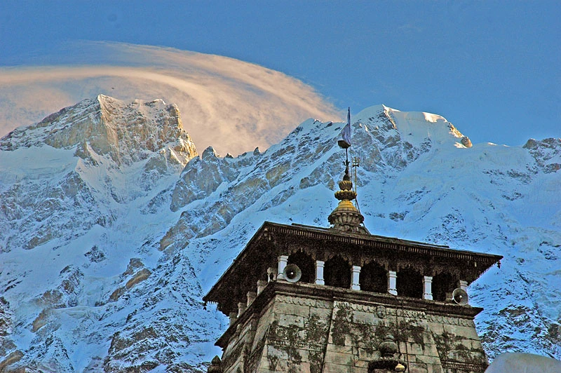
Kedarnath rests high within the Mandakini Valley of Uttarakhand, in the Rudraprayag district, at approximately 11,700 feet (3564 m) above sea level. Located in a high-altitude valley with steep surrounding mountains, glaciers, and river systems, Kedarnath is dramatically placed to appear remote.
Kedarnath's landscape has been formed by the extremes of the seasons. In winter, snow accumulates so heavily that it can completely obscure the region, and thus, all access to Kedarnath is cut off. However, during summer months, snow melts, feeding into the Mandakini River and exposing rocky ground, alpine plants and immense mountain views that support the valley's development.
As one of Lord Shiva's 12 Jyotirlingas (or sacred stones), Kedarnath's significance and status as one of Hinduism's foremost pilgrimage destinations earn it an esteemed place within the faith.
The main temple in the village dates back many centuries and serves as the focal point of the community. Thus, the cultural life of Kedarnath revolves very much around its churches (temples), religious festivals, and Yaksha (seasonal pilgrimage) events.
The following are treks that are located in the nearby region of Kedarnath: Chorabari Tal (Gandhi Sarovar) and Vasuki Tal.
8. Badrinath—Abode of Lord Vishnu
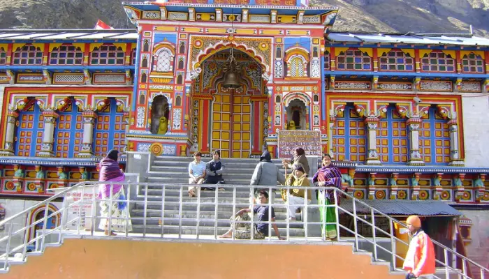
Badrinath sits within the Chamoli district of Uttarakhand, situated high in the Alaknanda Valley at 3168 metres above sea level. It can be found between two mountains known as Nar and Narayan, which create a natural corridor that has held paramount religious and geographical importance for many centuries. The altitude of Badrinath creates limitations on travel to and from it, but only for part of the calendar year.
The Badrinath landscape is affected by the extremes of seasonal change. In the winter months, the landscape is blanketed in heavy snowfall, making it completely inaccessible. The summer months are characterised by melting snow creating a fast-flowing river that supplies water to the Alaknanda river basin. This flow of water has created a dramatic landscape, consisting of steep, rocky slopes; rocky, alpine meadows; and wide expanses of mountains. The two surrounding mountain ranges and the river valley are the defining physical features of Badrinath.
Badrinath has a critical spiritual standing that has placed it amongst the great pilgrimage sites of India, as this temple is primarily devoted to Lord Vishnu and is also part of the Char Dham, or "Four Sacred Temples". In addition to its religious significance, the temple at Badrinath serves as the hub of the settlement and holds a central position within the community. This region has a deep-rooted cultural history, heavily influenced by religious customs and traditions. Further enriching the region's cultural and historical significance is the neighbouring village of Mana, recognised as the most remote settlement on the Indo-Tibetan border.
Treks available in the region around Badrinath: Satopanth trek, Vasudhara Falls route and Mana Village trails.
9. Ranikhet—Queen of Kumaon Hills
Ranikhet, a peaceful hill city in the Almora district of Uttarakhand, offers breathtaking scenery with its sweeping vistas towards the Himalayas. With a height of nearly 6,000 feet, Ranikhet allows visitors to appreciate a large number of the prominent peaks of the Himalayas and enjoy sweeping views of rugged, treeless hills and rolling valleys with abundant forests.
Ranikhet’s scenic beauty varies with the seasons – during the spring and summer months, you will be rewarded with bright green fields with blooming trees and bright blue skies, while during the winter months, colder temperatures and the occasional snowfall transform Ranikhet into a unique-looking area.
Ranikhet has historical significance as a British military cantonment town; therefore, there was not as much urbanisation of Ranikhet because of the presence of a military base, and therefore, development was controlled, which has maintained the natural values of this area.
It is much quieter than other, more commercialised hill stations and will be perfect for visitors seeking the cleanest, most beautiful environment possible away from heavily populated areas.
Nearby Ranikhet, you will find several trails: Jhula Devi Trail, Binsar Mahadev Route, and Chaubatia Orchard Walks.
Conclusion
Uttarakhand's geography (Himalayan) ceases to be an isolated area when considering spiritual (pilgrimage) and lifestyle. Colonial History: Mussoorie & Nainital; Sacred Sites: Kedarnath, Badrinath, Haridwar, Rishikesh; thus creating an intricate interrelationship of landscape, tradition, and people. Contrasting regions further define the state (i.e., Garhwal/Kumaon). High-altitude valleys, alpine meadows, forested hills, and river plains all contribute to this region's identity.
In addition to spiritual significance, Uttarakhand offers pristine natural environments, including areas that are protected, such as the Valley of Flowers, and less developed mountain communities such as Auli, Chopta, and Ranikhet. In these communities, development is limited, although the primary focus remains on seasonal/economic factors. Many mountain communities are also entry points into the western and eastern parts of India, providing access to many high-altitude areas of the Himalayas. Therefore, these locations serve not only as examples of Uttarakhand's geography, faith, and mountain culture but also to demonstrate the cultural and physical diversity of the Himalayas.