Bhangajyang Lakes Trek
TREK DIFFICULTY
Moderate
TREK DURATION
7 Days
HIGHEST ALTITUDE
13,540 feet
GROUP SIZE
12
TREK DISTANCE
25 Km
BASECAMP
Sikkim
BEST TIME
March to June and September to November
PICKUP POINT
Sikkim
Bhangajyang Lakes Trek Overview
Bhangajyang Lakes Trek is a one of the most beautiful treks of Arunachal and offbeat trekking trail located in the state of Sikkim, India. The trek offers breathtaking views of the surrounding mountains and valleys, with a high point of around 13,000 feet. The trek takes you through some wonderful landscapes of Arunachal Pradesh. As everyone knows, North-Eastern states are home to natural beauty. Bhangajyang Lakes trek takes you to vast valleys, big mountains, and beautiful glacial lakes. The trail passes through some remote villages of Arunachal Pradesh. There you can experience the rare north-eastern culture. Bhangajyang Lakes is among the few treks where the crude nature can be viewed.
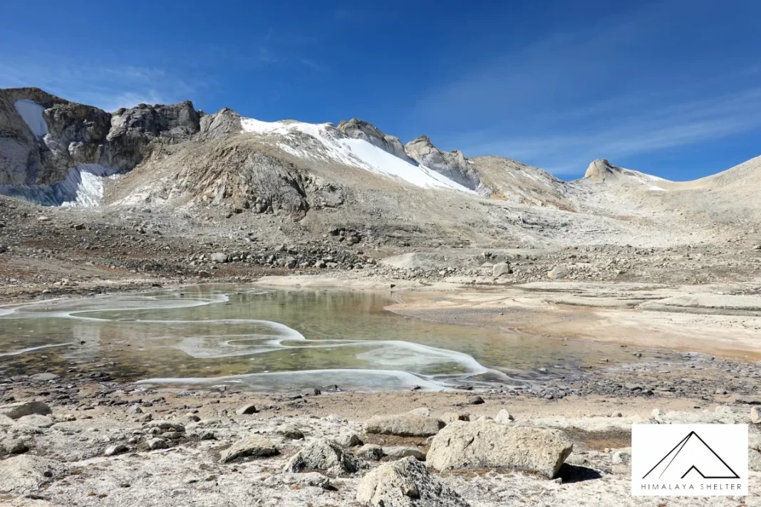
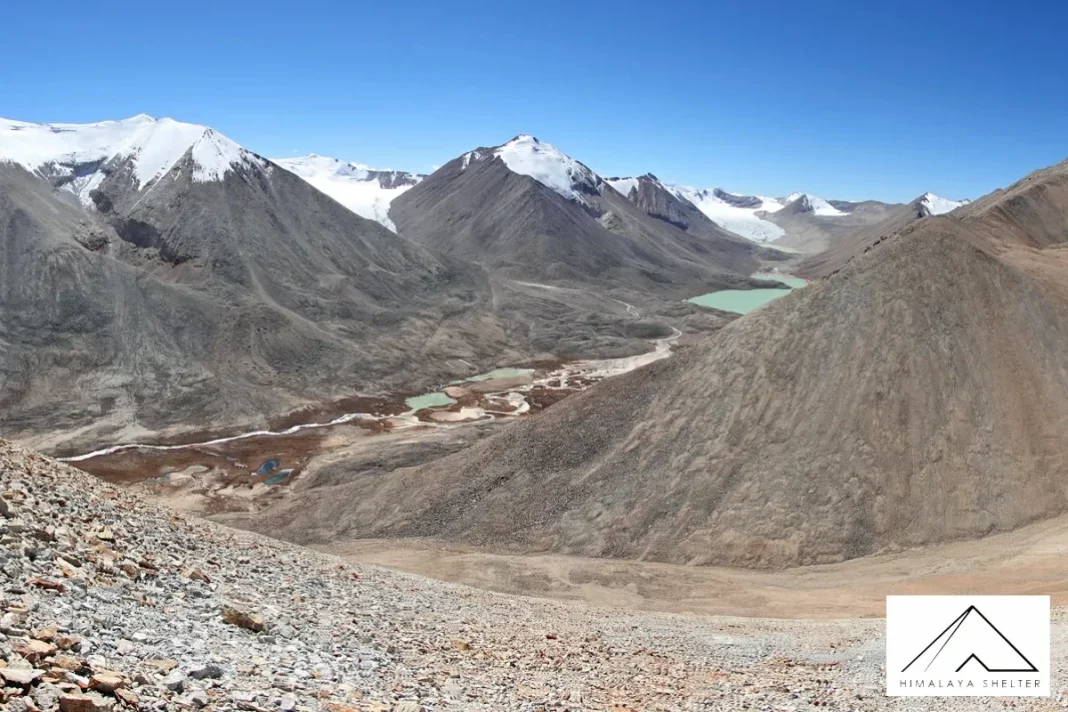
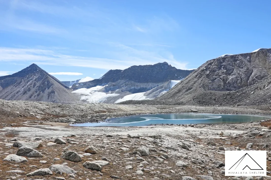
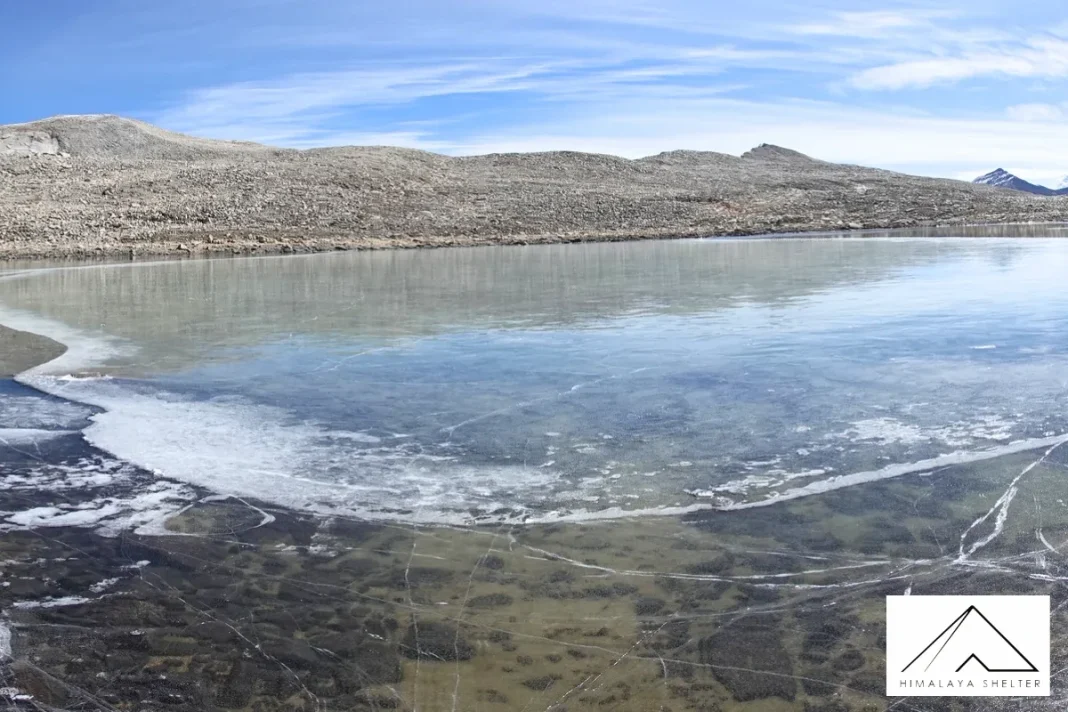
There are various high altitude lakes that are visible on the trek. The locals hold sacredness in these lakes. Individuals there are extremely respectful to nature. This adds spiritual significance to your journey. You will see big Himalayan ranges following you on the trek. The reflection of these ranges on the crystal-clear lakes are magnificent. This trek is also rich in bio-diversity. You can spot Rhododendron bloom and alpine beauty on the trek.
The best time to go on this trek is during the summer months when the weather is pleasant and the trail is easier to navigate. The trek is suitable for families with children and novice trekkers, as the difficulty level is moderate. The route takes you through dense forests, alpine meadows, and scenic lakes, making it an ideal outdoor activity for nature lovers. Camping is also an option along the trail, with several campsites available for trekkers. Bhangajyang Lakes Trek is a great way to escape the hustle and bustle of city life and enjoy a peaceful holiday in the lap of nature.
Day 1: Guwahati to Dirang (5354 ft) | Drive: 7 hrs
Day 2: Lubrang to Nagagigi (11,604 ft) | Trek: 5 hrs
Day 3: Nagagigi to Sangegigi (12,687 ft) | Trek: 5 hrs
Day 4: Sangegigi to Tsomjuk (13,054 ft) | Trek: 6 hrs
Day 5: Tsomjuk to Dolung (13,241 ft) | Trek: 7 hrs
Day 6: Dolung to Bhangajyang (13,540 ft) and drive to Dirang | Trek : 3 hrs
Day 7: Dirang to Guwahati Airport
Looking for the perfect Bhangajyang Lake Trek itinerary? Plan your expedition with us and get the most suitable tracking services. It will be our tree leader and professional guides who will guide you every step of the way. We tailor a perfect itinerary for your group. Our guides have good knowledge of the area, and our staff take care of everything.
Himalaya Shelter (HS) offers customized trekking services for Bhangajyang Lake trek. You decide the dates, and we create the best itinerary for you. We can customise meals, accommodation and group size for you. Our tree leader can also control the pace of the trip. Himalaya Shelter also accommodates special request,s such as pure vegetarian or Jain food. We also handle small group sizes and try our best to provide personalized tracking services.
The Bhangajyang Lakes have always been a part of Arunachal’s sacred landscapes. These lakes have spiritual beliefs among Brokpa communities. They believe that these beautiful lakes are home to mountain deities. The sacredness is one of the reasons that keeps these lakes clean and pristine. The trek to Bhangajyang used to serve as the trans-Himalayan route for trades. Traders used to travel from Arunachal to the neighboring countries like Bhutan and Tibet. They often trade silk, wool, salt with grains. Today, these trails serve as the trek routes. You can see remote villages on the trek. This part of Arunachal is less-crowded. Due to remoteness and less connectivity, only locals used to know about this trek. But today, the Bhangayang Lakes Trek is getting popular among trekkers and mountain lovers.
- Sacred High-Altitude Lakes: The trek will have a few glorious high altitude lakes. The waters of these lakes are crystal clear and appear to be highly pure. Every lake has some spiritual significance among the locals. These people often pray near these lakes. You can see the reflection of big mountains in these glacial lakes.
- Difficulty Level: The Bhangajyang trek is moderate to challenging trek. There are few difficult sections with steep ascents and rocky paths and mountain passes. The trek can be very physically challenging. The altitude is also over 4000m which can cause AMS. Trekkers should be physical and mentally prepared for this trek.
- Trek Peacefully: The Bhangajyang Lakes Trek is situated in an isolated site. The paths are lovely and noiseless. There will be very low traffic along the trail even during the peak season. There will be times when all you will hear is the chirping of birds and running streams. It is an ideal hike to get the raw beauty of the North-Eastern Himalayas.
- Culture Experience: The trek to Bhangajyang Lakes passes through some of the most beautiful villages of Arunachal. These villages are located in very remote locations and still hold the real Arunchali culture. You can interact with Brokpa people and learn more about their culture. You can also experience the warm hospitality of these communities.
- High-Altitude: The average altitude of the trek is around 4000m. This is an average height for Himalayan treks. People can get AMS over the height of 4000m. As we ascend the air starts getting thin. Oxygen level reduces and people start facing breathing problems. Trekkers should acclimate before starting the trek.
- Difficult Terrain: The terrain of the Bhangajyang Trek is also difficult. There are some challenging sections on the trek. The ascents are steep and difficult to cross. Good physical strength is needed since the mountain passes and rocky paths are hard. A trekker must possess some experience in pre-trekking in order to finish with the trek comfortably.
- Weather Conditions: The weather usually remains good in these regions. However, predicting weather in high-altitude areas is difficult. IIt is able to alter swiftly with no notice. The journey might also be complicated by Monsoon since the path is highly slippery and risky.
- Remotess: A very remote area of the Arunachal Pradesh is where the Bhangajyang Lakes are. There are scarcely any rest stops or any shops on the way. Trekkers have to carry all the gear with them. Any kind of medical help or rescue can take some time. You can mainly rely on the locals for help.
Bhangajyang Lakes Trek From April To June
Spring and summer is the best time to plan the Bhangajyang trek. The snow starts melting and the mountain passes become accessible for trekking. But you can still see snow in the high altitude zones around April. The valleys start turning green and the days become warmer. You can also see Rhodo bloom during spring.
Bhangajyang Lakes Trek In July & August
Monsoon is not a good time to plan the Bhangajyang Lakes trek. The trails become very slippery and muddy. Heavy rain makes the trek more difficult. There can be landslides or road blocks. You may also get lots of leeches in the forest area.
Bhangajyang Lakes Trek From September To November
Autumn is also a great time to plan your trek. The views are very amazing and landscapes become golden. You can also see cosmos blossoming in the valleys. The temperature starts falling and nights can be very cold. You can’t trek to Bhangayang in winters as the mountain passes bury in snow and the trail becomes inaccessible.
- Delhi To Guwahati: You can find direct flights from Delhi to Guwahati. Or, you can look for direct trains.
- Guwahati To Dirang: You can look for local buses or shared taxis to Dirang. The distance is 320 km and may take around 7 hours. Now continue to Lubrang village which is the basecamp for Bhanajyang Lakes Trek.
- Visit High-Altitude Lakes: The lakes are beautiful in the high-altitude. You will find many lakes up in the mountains. These glacial lakes possess crystal clear water. You may even notice the reflection of mountain ranges in it. These are lakes that are highly sacred.
- Enjoy the Landscape: The landscape of Bhangajyang Lakes Trek is so beautiful. You will see mesmerizing views everyday on the trek. The forest area is covered with beautiful Rhodo trees. The valleys are covered with wildflowers in summer. The flowing streams and high mountains makes the trek perfect.
- Engage With Locals: The trek is situated at an extremely isolated place of Arunachal Pradesh. You may witness communities like Brokpa. These people are mainly shepherds and live very simple lives. They have yaks and horses to carry the goods to the higher altitude areas. You can talk to them and learn more about rare Himalayan culture.
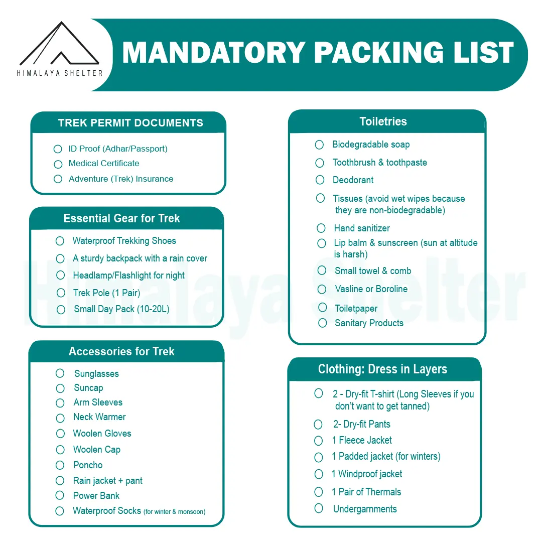
Mandatory Backpacking List for Aancha Top Trek
Clothing and Backpack
Get a good backpack (50 L) with a rain cover. Look for a bag that can provide you good back support. Pack 4 quick-dry t-shirts and 2 trekking pants. Get a pair of thermals (upper and lower) for night. Pack a fleece jacket or woolen sweater as a mid-layer. Get a waterproof wind breaker for sudden rain and chilly winds. For winter trekking, get a good down jacket. Now pack a woolen beanie and a balaclava. Get two pairs of gloves (woolen and waterproof). You should also pack a suncap for the daytime.
Footwear
You should look for good quality trekking shoes. Your shoes must be waterproof and provide good ankle support. Do not wear a new pair of shoes on the trek. Your feet must be familiar with the shoes. Now pack 4 pairs of trekking socks and 2 pairs of woolen socks. Pack a pair of comfortable slippers or sandals for the campsite.
Personal Care
For personal care items, start packing with your toiletries. Get a small zipper pouch and pack all the toiletries. Now look for a quick-dry towel and a toilet roll. You should also pack hand sanitizer and moisturizer. Pack a sunscreen that can protect your face from sunburn. You can also pack some snacks for the trek.
Physical Fitness Preparation for Trek:
To overcome the difficulty level of trekking, it requires strong cardiovascular endurance, muscular strength, and overall physical fitness. Incorporate these exercises into your routine to increase strength, stability, and stamina, which will help you tackle difficult terrain sections of the trail at high altitudes.
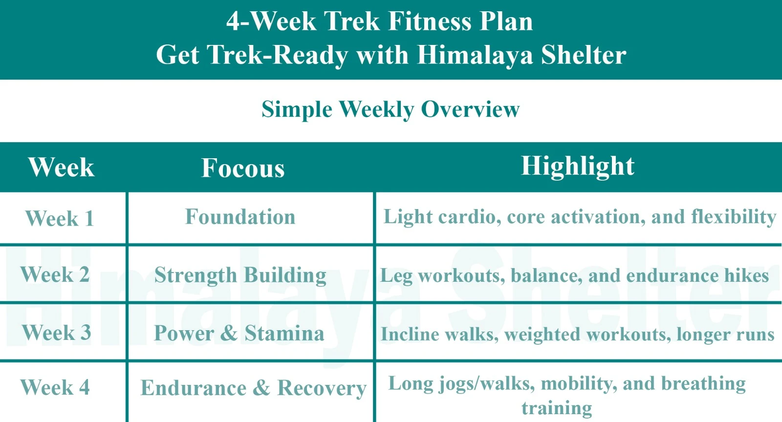
Overview

Foundation
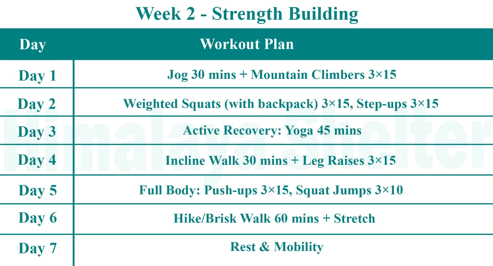
Strength Building
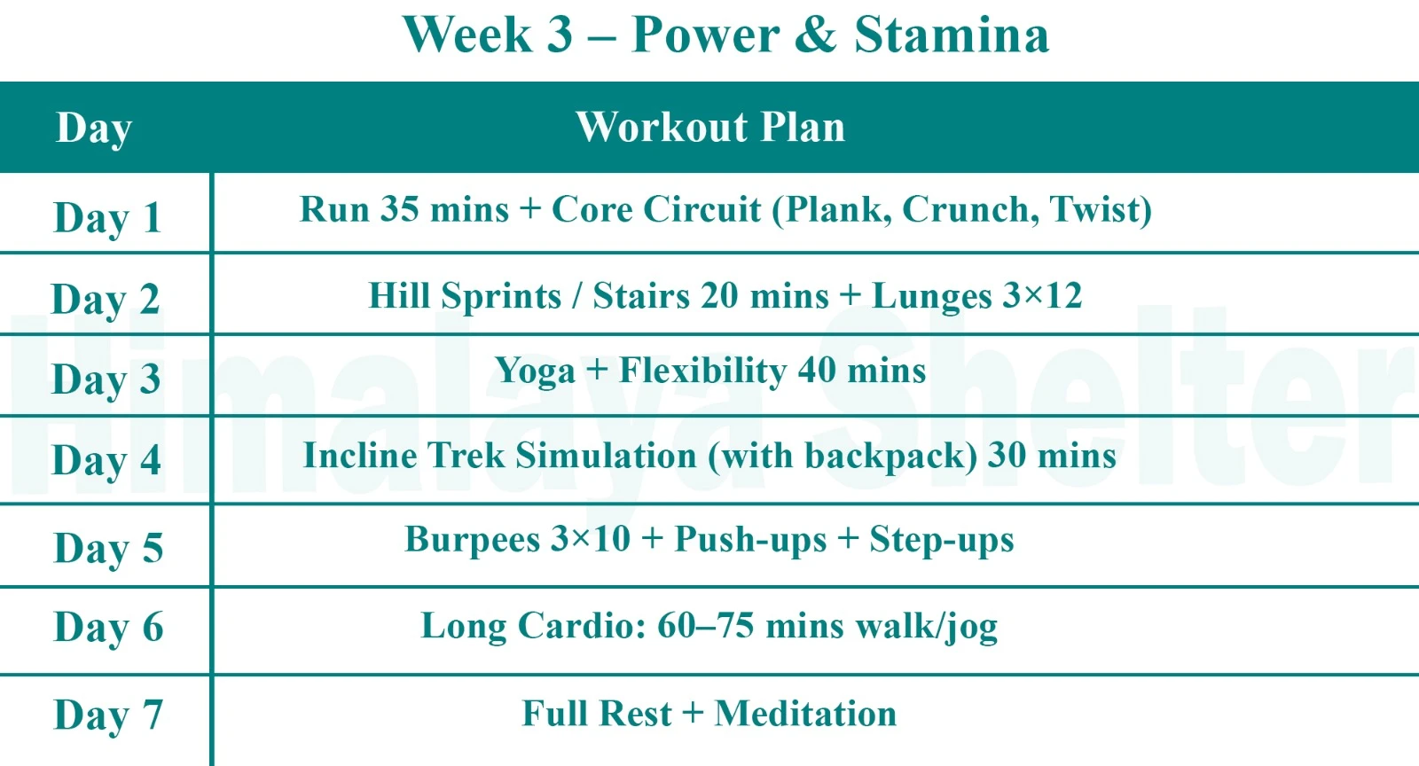
Power & Stamina
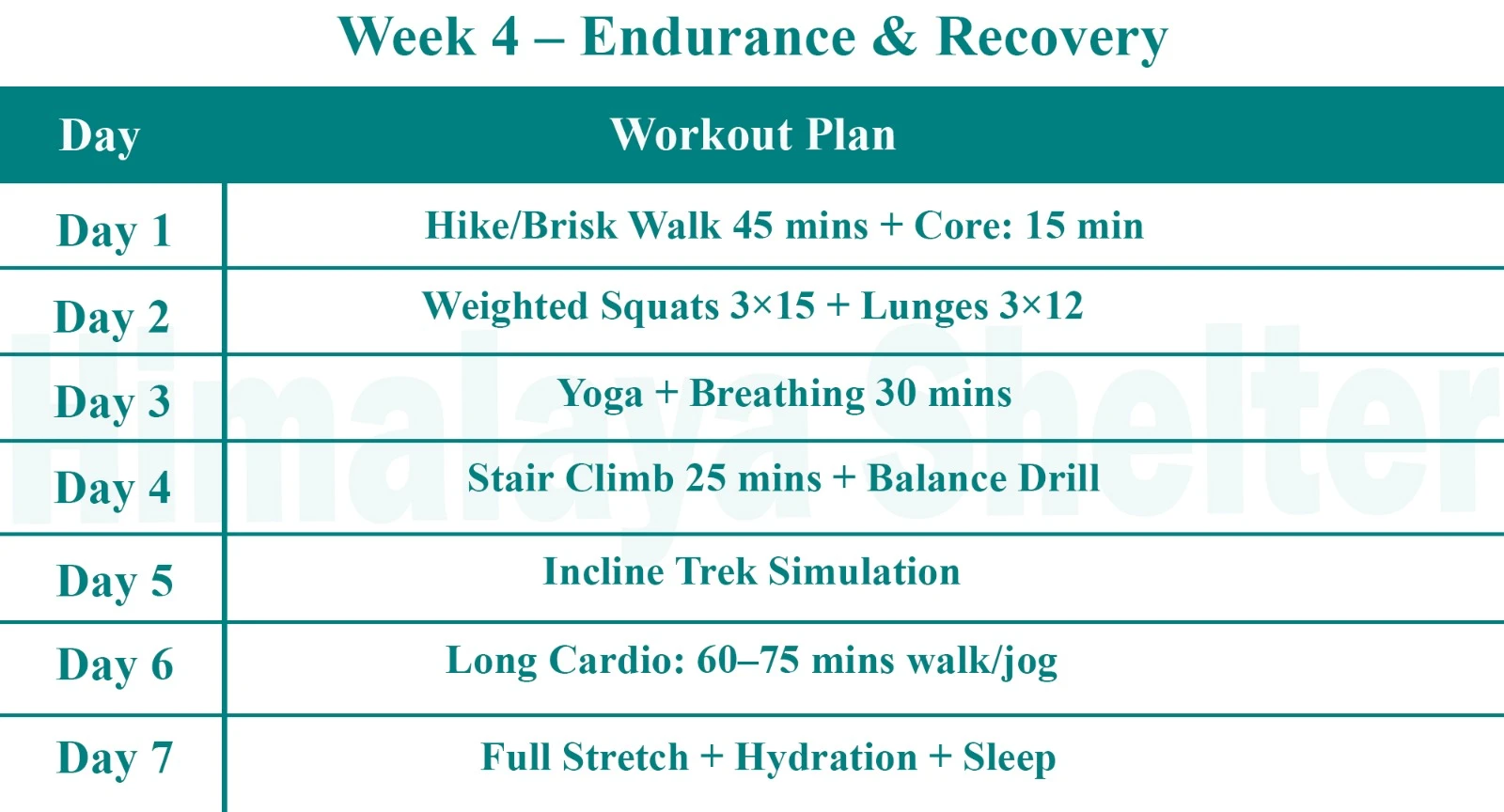
Endurance & Recovery
Day 1: Guwahati to Dirang (5354 ft) | Drive: 7 hrs
The drive from Guwahati to Dirang is approximately 7 hours, covering a distance of about 320 kilometers.
The journey will take you through the picturesque landscapes of Assam and Arunachal Pradesh.
Reach Dirang, which is situated at an altitude of approximately 5,354 feet (1,632 meters) above sea level.
Day 2: Lubrang to Nagagigi (11,604 ft) | Trek: 5 hrs
Begin the trek from Lubrang to Nagagigi The trail will lead you through varied landscapes, including forests, meadows, and possibly some rocky paths.
reach Nagagigi which is a serene location situated at an altitude of approximately 11,604 feet (3,537 meters) above sea level.
Day 3: Nagagigi to Sangegigi (12,687 ft) | Trek: 5 hrs
Begin the trek from Nagagigi to Sangegigi.
The trail will lead you through a variety of terrains, including meadows, rocky paths, and possibly some snow patches depending on the season.
Reach Sangegigi is a picturesque location situated at an altitude of approximately 12,687 feet (3,867 meters).
Day 4: Sangegigi to Tsomjuk (13,054 ft) | Trek: 6 hrs
Start the trek from Sangegigi to Tsomjuk generally takes about 6 hours.
The trail will lead you through diverse landscapes, which may include meadows, rocky terrain.
Reach Tsomjuk is a picturesque location situated at an altitude of approximately 13,054 feet (3,979 meters).
Day 5: Tsomjuk to Dolung (13,241 ft) | Trek: 7 hrs
Start the trek from Tsomjuk to Dolung typically takes about 7 hours. The trail will lead you through a variety of terrains.
Arrive at Dolung is a picturesque location situated at an altitude of approximately 13,241 feet (4,035 meters) above sea level.
Day 6: Dolung to Bhangajyang (13,540 ft) and drive to Dirang | Trek : 3 hrs
Begin the trek from Dolung to Bhangajyang typically takes about 3 hours.The trail will lead you through diverse terrains, including meadows.
Reach Bhangajyang is a picturesque location situated at an altitude of approximately 13,540 feet (4,121 meters).
Day 7: Dirang to Guwahati Airport
The drive from Dirang to Guwahati Airport typically takes about 7 to 8 hours,
Our treks are specially designed by the experienced team at Himalaya Shelter, taking you on an adventure of a lifetime all while making you connect not only with the bountiful nature but also with yourself and with others on the trek with you creating wonderful memories which will last you a lifetime. All Himalaya Shelter treks are guided by experienced Trekkers having vast knowledge and experience of the region, providing with insightful information and stories pertaining to the region’s flora and fauna and the history of the region whilst the trek. It is safe to say that on successfully completing the trek, one will gain tremendous insight and experience along with lifetime memories.
Bhangajyang Lakes Trek Inclusion
- Accommodation – At Base Camp, stay at a local homestay or guest house for one night each, which will give you an insight into the authentic lifestyle of the locals.( INR 5000 per person extra for single sharing throughout the trek )
On Trek stay in a 2-person Vango Halo Pro/A-Shape tent, which is to be shared by two trekkers, built to withstand extreme weather conditions and at the same time making you comfortable after a hard day’s trek. - Camping Equipment – specially designed sleeping bags that can withstand harsh weather conditions, foam mattresses. Other safety gear like microspikes, gaiters, an ice axe, and helmets will be provided.
- Medical Kit – our team will be equipped with an extensive medical kit, which our team is trained and experienced to use. Oxygen cylinders are used after they are thoroughly inspected throughout the Trek. Even campsites have large oxygen cylinders as backups.
- Permission - Forest entry charges for Indian nationals (Additional charges will be applicable for international tourists)
- Meals – Breakfast, packed lunch (on trek days), evening snacks, and dinner will be served. A hearty, delicious, and nutrition-filled Veg meals with egg preparation will be provided throughout the trek. (Jain and Vegan Food can also be arranged on prior notification.)There will be a dedicated Kitchen Tent along with a dining tent, which will have a dining table too.
- Our Team – A highly experienced and AMC-certified Trek Leader who will help ensure that the entire trek goes smoothly and safely while navigating the challenging conditions during the trek, and is skilled enough to navigate any medical emergency that can arise during the trek. Local and route Guides who are well-versed with the region and provide an in-depth insight into the local customs and knowledge of the flora and fauna endemic to the region. A dedicated Kitchen staff, which includes a Cook, a helper, and other support staff. There will also be porters and mules to carry common equipment.
- Cloakroom - We have a cloakroom facility available for extra luggage. Every trekker is permitted to leave their luggage behind at no charge.
Bhangajyang Lakes Trek Exclusion
- Personal expenses like tips, personal medicines, phone calls etc.
- Travel Expenses - Travel expenses from your hometown to the mentioned Pick-Up Point are not included in the trek fee.
From the scheduled pick-up spot to the base camp, we have our own fleet of vehicles like Bolero, Innova, Dezire, or Tempo Traveler (12-seater). This is be shared by trekkers for a pre-decided amount. All vehicles are non-AC. - Personal Equipment - Any personal gear like jackets, shoes, cutlery, or backpacks are not included in the trek fee. We recommend renting them from our Rental Store for an affordable fee. This can be pre-arranged to avoid last-minute hang-ups.
- Offloading - We encourage carrying your backpack to get into the true spirit of trekking. However, if needed, you can opt to offload your personal luggage of up to 12 kgs for an additional cost of INR 600 per bag per day.
- Trek Insurance - A mandatory trek insurance fee is charged in addition to your trek fee. Since most medical insurance doesn’t cover adventure activities, trek insurance offers essential coverage, enhancing your safety without a significant financial burden.
- Buffer day on the trek - We have kept a buffer day on the trek to account for any weather-related delay. If this is utilized, you will need to pay an extra amount to your trek leader.
- Anything apart from inclusions
- Please carry a lunch box for a packed lunch/breakfast to avoid using polythene and Aluminium foil.
Keeping the Himalayas clean is our own responsibility. Reduce the use of Plastic when you are in the abode of the Sacred Himalaya.
Read More on Bhangajyang Lakes Trek
Photo Gallery
Treks by Categories
Treks By Month

Treks By Experience


