Uttarey Singalila Trek
TREK DIFFICULTY
Moderate
TREK DURATION
15 Days
HIGHEST ALTITUDE
16,207 feet
GROUP SIZE
12
TREK DISTANCE
155 Km
BASECAMP
Sikkim
BEST TIME
Mid-March, April to May and Mid-September, October to November
PICKUP POINT
Sikkim
Uttarey Singalila Trek Overview
The Uttarey Singalila Trek in Sikkim is a popular summer trekking route in India that offers stunning views of the Himalayas. The trek starts from Uttarey, a small village in West Sikkim, and takes you through the Singalila range, passing through dense forests of rhododendron and oak trees. The highest point of the trek is Sandakphu, which stands at an altitude of 16,207 feet. The trek offers panoramic views of the Kanchenjunga and Everest ranges, as well as the Tibetan plateau. This trek is suitable for families with children who enjoy outdoor activities such as camping and trekking. The best time to visit is from April to June and from September to November. During the trek, you will come across several campsites with basic amenities, making it a comfortable and enjoyable experience for all.
Uttarey Singalila is likely to be the most picturesque trek of Sikkim. North-Eastern states as we all know are known for their natural beauty which has remained untouched by human beings. The Uttarey Singalila is a trek in which you will be able to get some of the most beautiful scenery of Sikkim. It is a journey that is an adventure towards nature. The path goes through large forest strips, wide fields, and picturesque isolated villages.
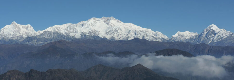
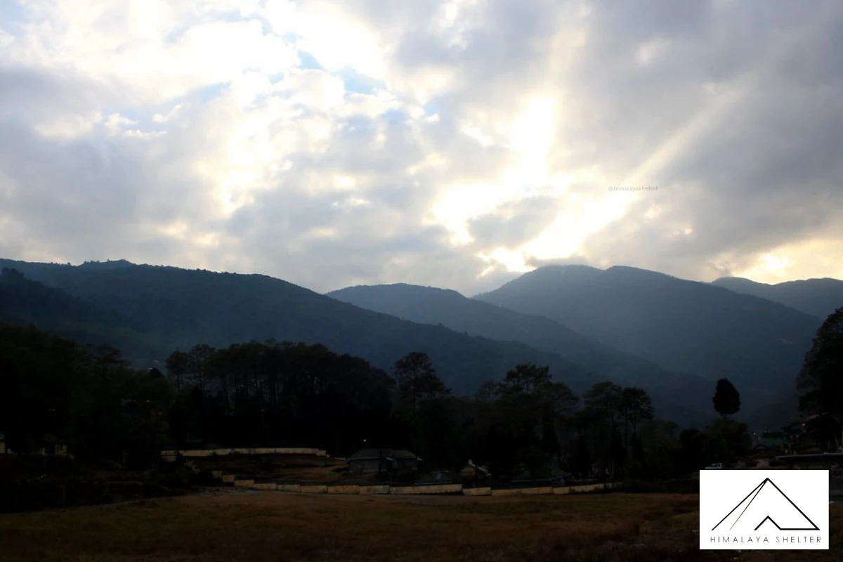
The Uttarey Singalila Trek is located in an offbeat location of Sikkim. The views are breathtaking where you will see the Kanchanunga range in front of you. Uttarey Singalila Trek can give you the glance of real Eastern Himalayas. You will walk along the Indo-Nepal border. This part is known as Singalila Ridge from where you can see the four highest peaks of the world. The sunrise and sunset views from the Uttarey Singalila are mesmerizing.
Day 1: Uttarey to Chiwa Bhanjyang (10,498 ft) | Trek: 14 km in 6 - 7 hrs
Day 2: Chiwa Bhanjyang Rest and Acclimatization (10,498 ft) | Trek: 4 - 5 hrs
Day 3: Chiwa Bhanjyang to Ghairi (11811 ft) | Trek: 10 km in 5 - 6 hrs
Day 4: Ghairi to Dhor (12,795 ft) | Trek: 9 km in 5 - 6 hrs
Day 5: Dhor to Pare Megu (12,467 ft) | Trek: 12 km in 6 - 7 hrs
Day 6: Pare Megu to Lam Pokhari (13,451 ft) | Trek: 11 km in 4 - 5 hrs
Day 7: Lam Pokhari to Gomathang (11,482 ft) via Dafey Bhir (14,763 ft) | Trek: 9 km in 5 - 6 hrs
Day 8: Gomathang to Pangden (13451 ft) | Trek: 16 km in 7 - 8 hrs
Day 9: Pangden to Dzongri (13,221 ft) | Trek: 9 km in 5 - 6 hrs
Day 10: Dzongri Rest and Hiking Day (13,221 ft – 13,943 ft) | Trek: 4 - 6 hrs
Day 11: Dzongri to Thangsing (12,893 ft)| Trek: 6 km in 5 - 6 hrs
Day 12: Thangsing to Lamune (13,549 ft) | Trek: 6 km in 3 - 4 hrs
Day 13: Lamune to Goechala (16,207 ft) | Trek: 14 km in 5 - 6 hrs
Day 14: Thangsing to Tsokha (10,006 ft) via Kockchurung | Trek: 14 km in 6 - 7 hrs
Day 15: Tshoka to Yuksam (5,856 ft) | Trek: 16 km in 6 - 7 hrs
Planning your trip to North Singalila? Plan your trip with the best tour company. We are here to make your trekking journey adventurous and convenient. Our tour leaders and guides have good knowledge of the area. They will ensure your safety throughout the trip. Our helpful staff will take care of your convenience and manage everything for you.
Himalaya Shelter (HS) provides you customized tour services. You decide the dates for your Uttar Singalila trek and we will prepare the itinerary for you. Our team will create the best work itinerary including accommodation, meals and everything else. Our tour guide can also control the pace of the tour after you. We work closely with local people to deliver an authentic local experience.
The Uttarey Singalila Trek has deep roots with culture and geographical history. The trail of Uttarey Singalila follows the border area of India and Nepal. This trail is known as Singalila ridge which is a natural border between these two countries. The Singalila ridge was one of the most favored routes of the exchange of trade and culture between India and Nepal. Traders used to pass through this ridge to trade salt, wool and grains. Many monks also used to walk on this same ridge to visit Monasteries. This trail became the path for cultural exchange and Buddhist teachings. On the way, there are a great number of small-big Monasteries and Chortens. Walking on the trail will be a full adventure with some pristine natural beauty.
There is a small village at an altitude of 7,800 feet near the Nepal border in North West Sikkim. It is also a place for trekking up to Uttarei Singalila Range, which is one of the famous hiking locations in West Sikkim. There are also restaurants and cabins in the village. Defense and Statistics Norway departments are in the north. After crossing the Singshore Bridge, about 10 kilometers away, you can reach Uttare, a beautiful landscape view.
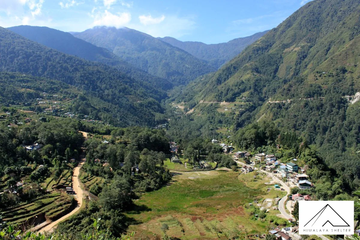
- Beautiful Uttarey Village: Uttarey is the basecamp for this trek. The village is small and full of greenery. It is nested in a very peaceful location. Uttarey locals are very hospitable. Not to mention the numerous homestays to stay and have the hospitality.
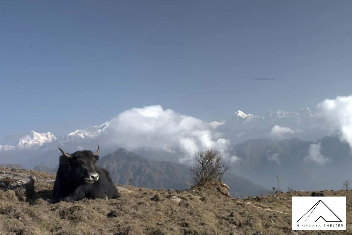
- Best Himalayan Views: Uttarey Singalila is a trek from where you can get the magnificent views of Kanchanjunga range. It will follow you on the whole trek. You will also get great views of the top highest peaks of the world : Mt Everest, Mt. Lhotse, and Mt. Makalu. The Eastern Himalayan ranges look very beautiful from the Uttarey Singalila Trek.
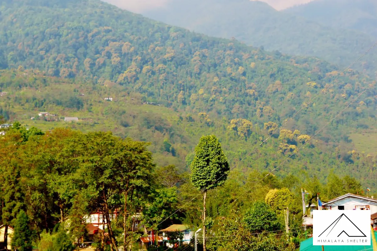
- Flora And Fauna: The Uttarey Singalila Trek is endowed with flora and fauna. You will walk through Rhodo forests and big open meadows. During summer wildflowers cover these meadows. Cosmos are also growing everywhere around the Singalila ridge in Autumn. You might even be lucky to see Himalayan birds and butterflies which are rare.
- Rich Culture: This trek is more like a cultural journey. You can experience the rich culture of Sikkimese people. There you can see a mixture of Hindu and Buddhist beliefs. The locals still follow some of the centuries old customs. Trekkers can visit the Monasteries and learn more about spirituality.
- High-Altitude: The average altitude of Uttarey Singalila Trek is about 4000m. Ascending to this much height is difficult. Many trekkers can also get AMS symptoms once they cross 4000m. The air becomes thin and breathing becomes difficult. The altitude is not very high but still people can get breathing problems.
- Weather Condition: The weather usually remains pleasant in Sikkim. However, sometimes nights can be very cold. You can trek comfortably when the weather is good. But the weather can change rapidly in the high altitude zones. You can face chilly winds and even snowfall sometimes. Rain can make your trek more difficult.
- Trek Length: The Uttarey Singalila Trek is very long. It is a 155km long trek and takes about 2 weeks. This much long trek can be physically and mentally tiring. Walking for two straight weeks is not easy. The walking hours are also long. You have to walk about 5-6 hours daily.
- Terrain: Uttarey Singalila Trek terrain is a combination of slow ascends, sharp climbs and boulders. It is not hard to walk on forested grounds and slow inclines. Even long walks in the forest can be easily made by the trekkers. But, sharp ascents and mountainous terrain are tedious. A step is heavy even sometimes.
-
Uttarey Singalila Trek From March To May
Spring is the best time to plan your Uttarey Singalila Trek. The trail became very beautiful and mesmerizing. Snow melts and the path becomes open to trekkers. Rhododendrons are in blossom in the forest area. The temperature starts rising but the nights may still feel cold.
-
Uttarey Singalila Trek From June To August
Monsoon means slippery trails. This is not a good time to plan your Singalila trek as this area receives a good amount of rain. The trails become muddy and very slippery. Walking on these trails is difficult. You can see plenty of leeches in monsoon.
-
Uttarey Singalila Trek From September To November
Autumn is also a good time to trek Uttarey Singalila. After the monsoon, everything seems clean. You will get clear views of Himalayan ranges. The landscapes start turning golden. You will notice a decrease in temperature but the days might not be cold. Snowfall will occur in the high altitude regions in November. After this season, trekking becomes very difficult as the trails bury inside the snow.
- Delhi To Bagdogra / New Jalpaiguri: You can take a direct flight from Delhi to Bagdogra. Or, look for the direct trains to New Jalpairguri.
- Bagdogra / New Jalpaiguri To Uttarey: Hire a taxi or look for a shared taxi to Singalila. The distance is about 160km and will take around 7 hours.
- Enjoy The Panoramic Himalayan Views: Uttarey Singalila is a great trek to enjoy the Himalayan views. While on the trek, Mt. Kanchenjunga will follow you all the time. The sunrise and sunset also look incredible. This is one of the treks from where you can witness the four highest Himalayan ranges of the world.
- Visit Monasteries: Uttarey Singalila route has many small-big monasteries. These monasteries are the sign of cultural exchange between the countries. You can visit the Monasteries and offer your prayers. There are also many chortens along the route. These monasteries and chortens offer peace and cultural glance of Sikkim.
- Camping In The Nature: All the campsites of Uttarey Singalila Trek are very beautiful. You can enjoy the raw nature at its best. Somedays, you will camp in the vast meadows, some days you will camp near forests. You will be surrounded by beautiful snow-capped mountain ranges under the starry night.
- Capture Beautiful Landscapes: Uttarey Singalila is a great trek for landscape photographers. It is a two week long trek but everyday has something special. The landscape changes every day. Even the morning and evening feel different from the same point. You can take lots of pictures for memories.
Buy a good rucksack (60L) with a rain cover. Now pack 4 quick-dry T-shirts and 2 pairs of hiking pants. One should pack a pair of thermals, a fleece jacket and a down jacket to have warm layers. Add a wool hat, gloves and buff to keep you extra warm. A good rain jacket should always be packed. Now pack comfortable trekking shoes, a few pairs of socks and a pair of sandals. Take a ziplock bag and pack cosmetics. Now pack a small bag (20L) for a day trip. Carry some cash and public ID.
Travel Tips & Safety Guidelines
- Acclimatization: Always acclimatize yourself for the high-altitude trek. On acclimatization day, give your body some rest. Go for a small hike, look around and try to breathe properly in the thin air. Keep yourself fully hydrated and avoid smoke / drink.
- Camp Responsibly: You will be camping in some of the most beautiful locations. Do not throw garbage, especially plastic. Carry all your plastic back with you. Avoid using loud speakers and maintain the noise level. Keep your surroundings peaceful and serene.
- Connectivity & Emergency: The mobile networks can be very weak in many areas. Whenever you get the signals, always call your family member and share your location. Avoid overusing your phone and save the battery. Keep the contact number of the local authorities and trek operators for any kind of emergency.
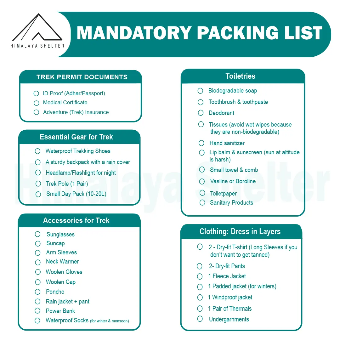
Mandatory Backpacking List for Aancha Top Trek
Clothing and Backpack
Get a good backpack (50 L) with a rain cover. Look for a bag that can provide you good back support. Pack 4 quick-dry t-shirts and 2 trekking pants. Get a pair of thermals (upper and lower) for night. Pack a fleece jacket or woolen sweater as a mid-layer. Get a waterproof wind breaker for sudden rain and chilly winds. For winter trekking, get a good down jacket. Now pack a woolen beanie and a balaclava. Get two pairs of gloves (woolen and waterproof). You should also pack a suncap for the daytime.
Footwear
You should look for good quality trekking shoes. Your shoes must be waterproof and provide good ankle support. Do not wear a new pair of shoes on the trek. Your feet must be familiar with the shoes. Now pack 4 pairs of trekking socks and 2 pairs of woolen socks. Pack a pair of comfortable slippers or sandals for the campsite.
Personal Care
For personal care items, start packing with your toiletries. Get a small zipper pouch and pack all the toiletries. Now look for a quick-dry towel and a toilet roll. You should also pack hand sanitizer and moisturizer. Pack a sunscreen that can protect your face from sunburn. You can also pack some snacks for the trek.
Physical Fitness Preparation for Trek:
To overcome the difficulty level of trekking, it requires strong cardiovascular endurance, muscular strength, and overall physical fitness. Incorporate these exercises into your routine to increase strength, stability, and stamina, which will help you tackle difficult terrain sections of the trail at high altitudes.
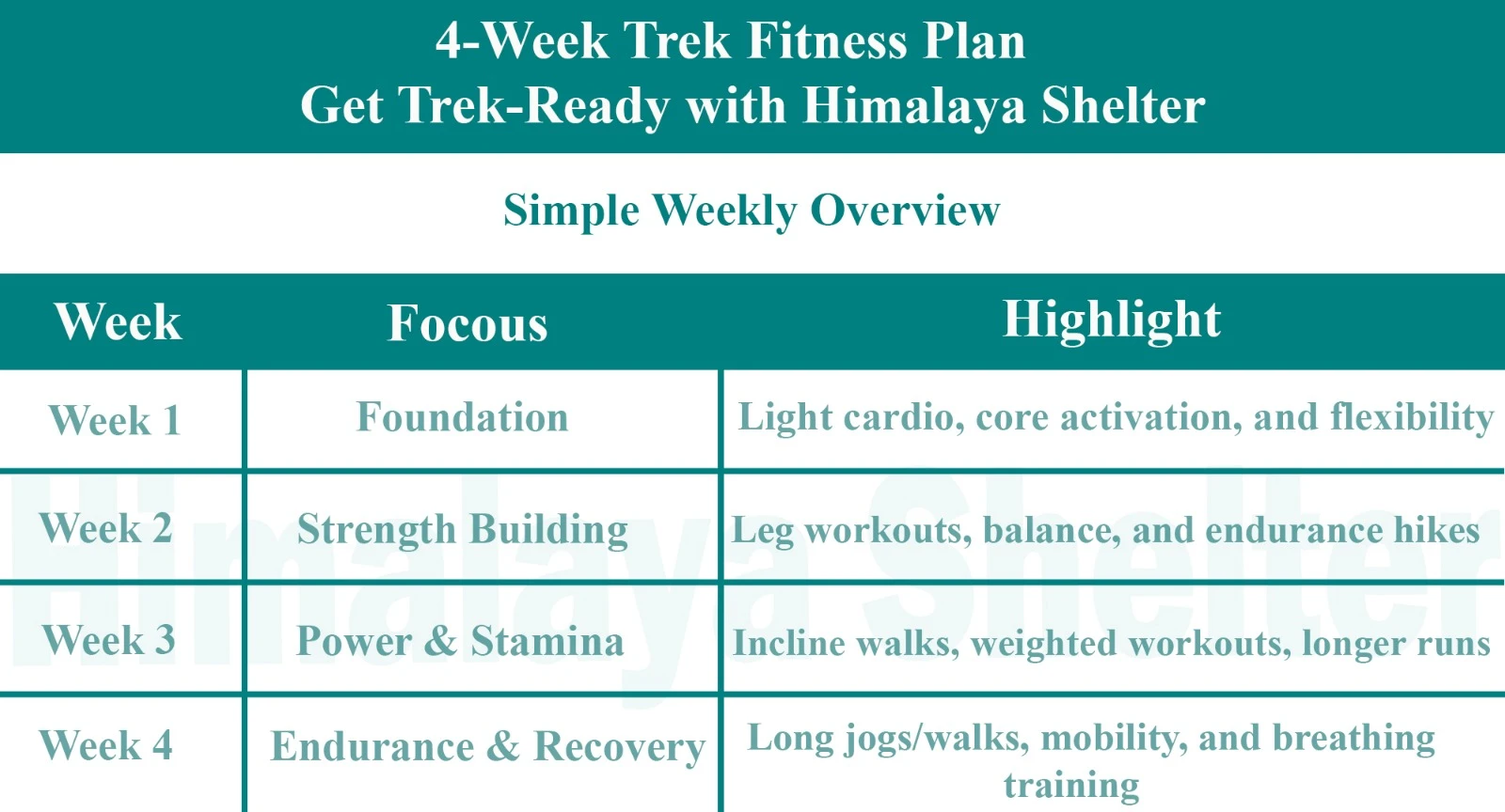
Overview
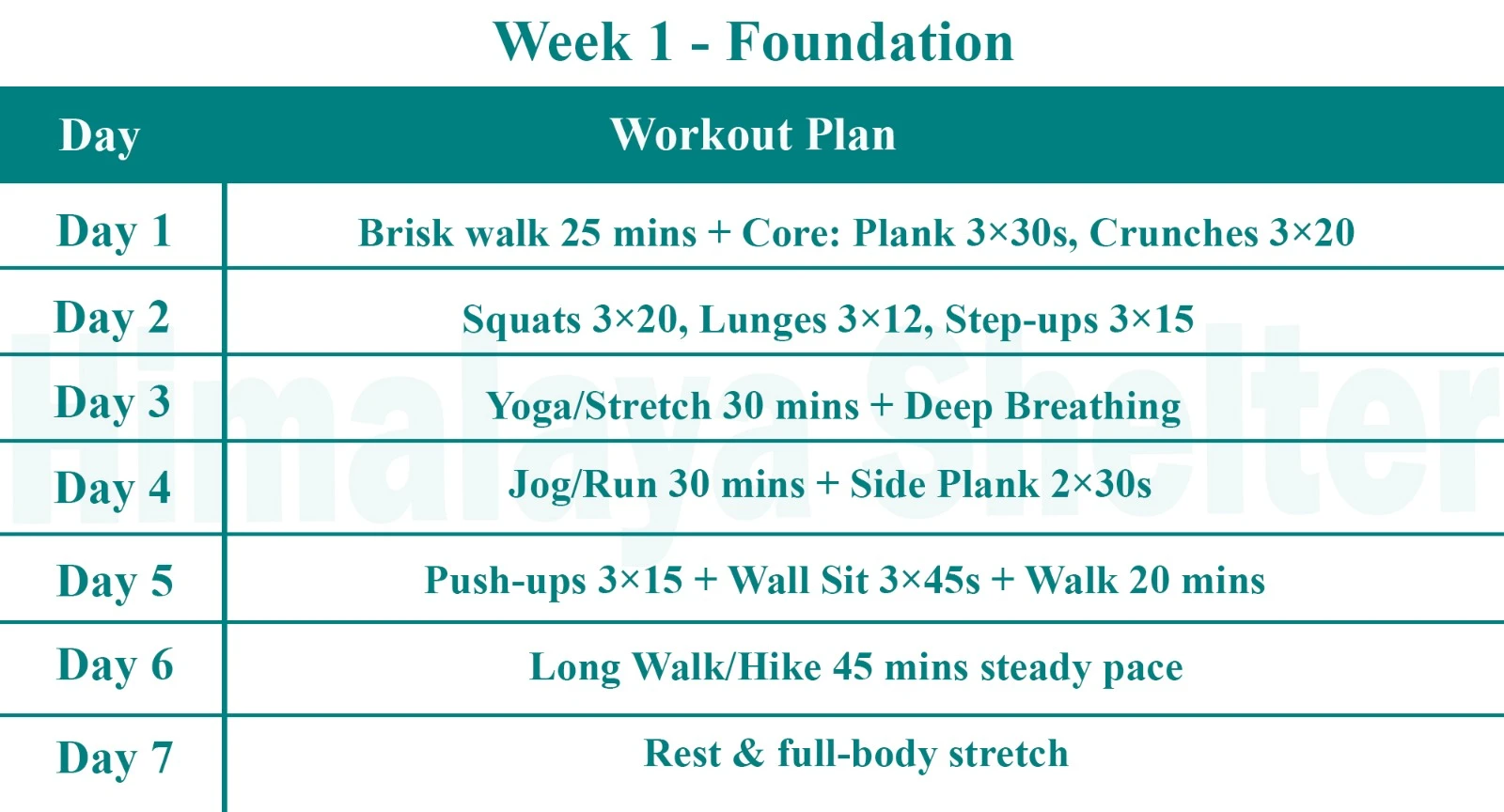
Foundation
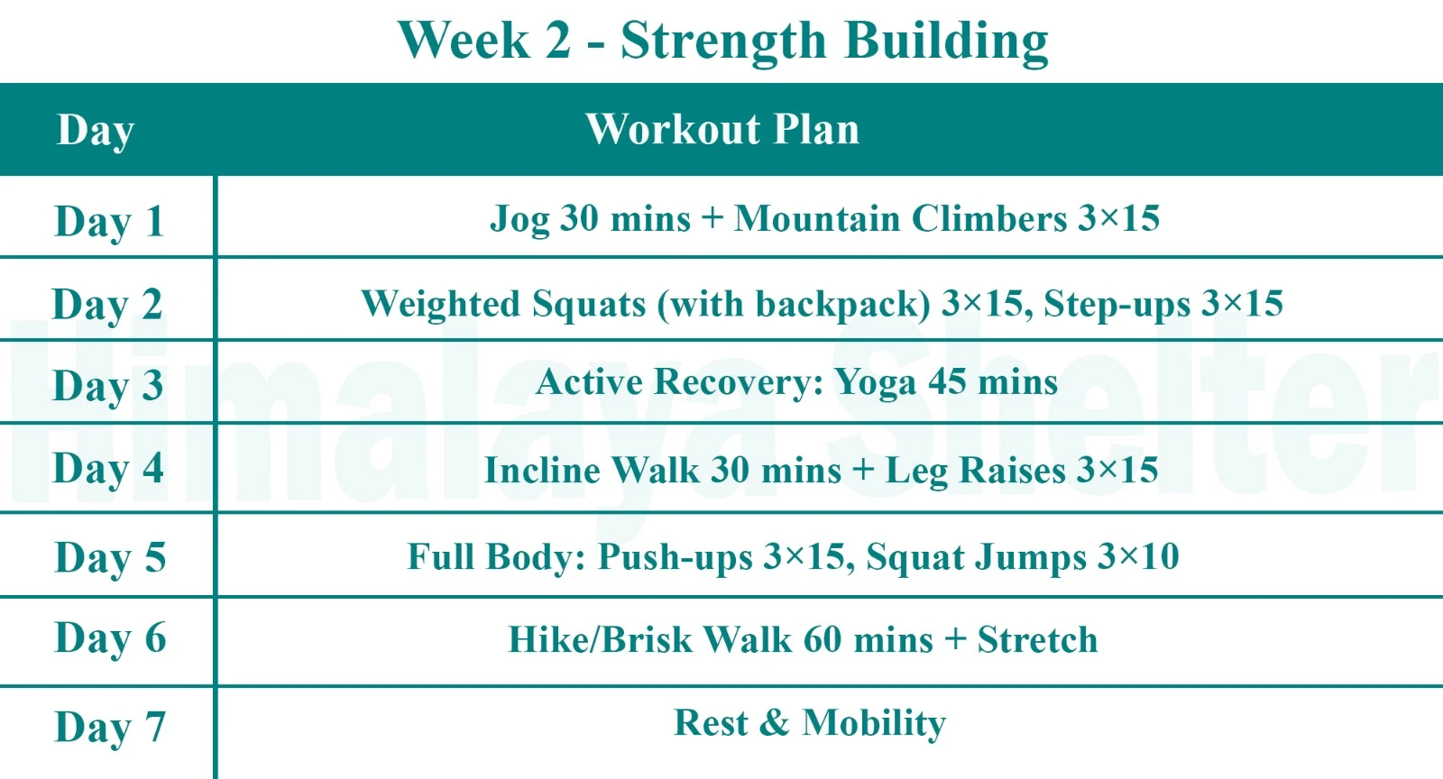
Strength Building
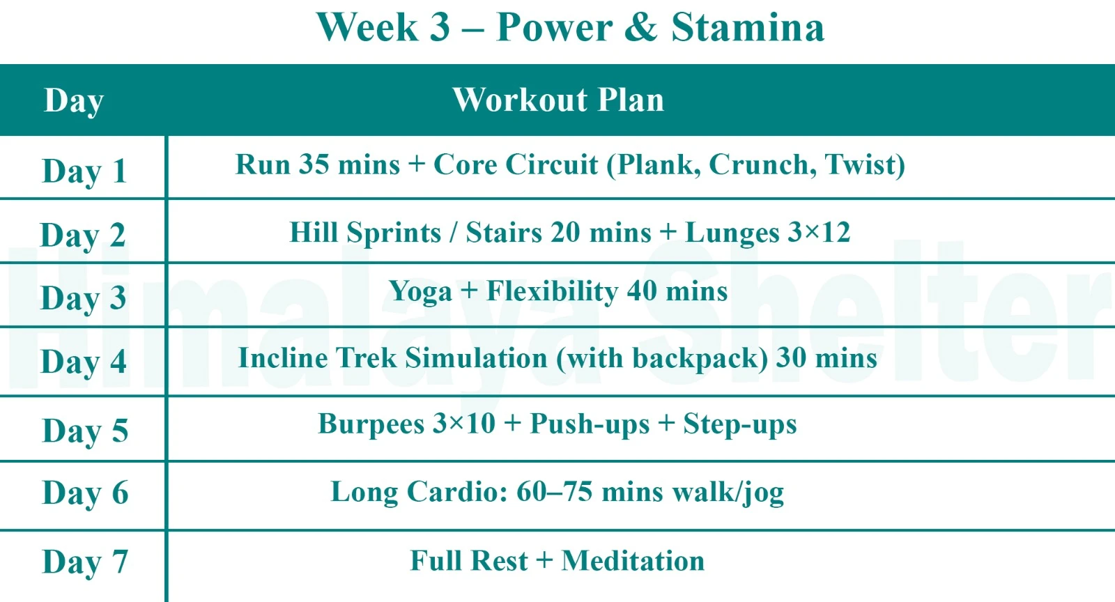
Power & Stamina
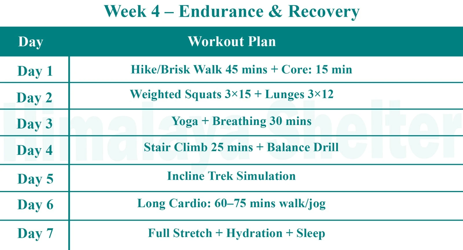
Endurance & Recovery
Day 1: Uttarey to Chiwa Bhanjyang (10,498 ft) | Trek: 14 km in 6 - 7 hrs
We will start trekking from Uttarey to Sangalila ridge. The trek is about 14 km but the trail is easy.
Day 2: Chiwa Bhanjyang Rest and Acclimatization (10,498 ft) | Trek: 4 - 5 hrs
Today, we will take a good rest or go for a small hike. This day is for acclimatization as the upcoming high-altitude trail.
Day 3: Chiwa Bhanjyang to Ghairi (11811 ft) | Trek: 10 km in 5 - 6 hrs
Today’s trek towards Ghairi is easy. The walk is not challenging and we will go 9km within 6 hours.
Day 4: Ghairi to Dhor (12,795 ft) | Trek: 9 km in 5 - 6 hrs
On Day 4, we will walk through a forest and then trek uphill. You will see prayer flags along the trail. We will walk about 9 km which may take around 6 hours.
Day 5: Dhor to Pare Megu (12,467 ft) | Trek: 12 km in 6 - 7 hrs
It is down and up to-day across one side of the ridge to another steep ascent. The path is a combination of moderate to easy trails. We are going to cover 12km, which can take 7 hours.
Day 6: Pare Megu to Lam Pokhari (13,451 ft) | Trek: 11 km in 4 - 5 hrs
Today, the trek is easy and we will start walking early. The distance is about 11km which may take 5 hours. By the afternoon, we will reach the campsite and acclimatize for further journey.
Day 7: Lam Pokhari to Gomathang (11,482 ft) via Dafey Bhir (14,763 ft) | Trek: 9 km in 5 - 6 hrs
After walking two days in Nepal, we will reenter Sikkim. We will walk towards a steep descent to reach the campsite. We will walk 9 km which takes around 6 hours.
Day 8: Gomathang to Pangden (13451 ft) | Trek: 16 km in 7 - 8 hrs
Today we will start ascending towards Pangden. The ascend and descent is a bit difficult today. We will walk for 16 km which will take about 8 hours.
Day 9: Pangden to Dzongri (13,221 ft) | Trek: 9 km in 5 - 6 hrs
Today we will join our route to Goecha La trek. There is a steady climb that opens to summer pasture. We will trek 9km which will take about 6 hours.
Day 10: Dzongri Rest and Hiking Day (13,221 ft – 13,943 ft) | Trek: 4 - 6 hrs
We will take a day's rest at Dzongri. This day is for acclimatization. You can stay at the campsite or can go for a day hike.
Day 11: Dzongri to Thangsing (12,893 ft)| Trek: 6 km in 5 - 6 hrs
We will start ascending followed by a sharp descent. We will cross the boulders and reach the campsite of Thangsing. Today we will trek 6km.
Day 12: Thangsing to Lamune (13,549 ft) | Trek: 6 km in 3 - 4 hrs
Today we will walk towards Lamune which is 6 km away and will take only 4 hours. After reaching the campsite, we will hike to Samiti lake. The trail passes through Rhodo bushes and prayer walls. We will also hike back to the camp after having visited the lake.
Day 13: Lamune to Goechala (16,207 ft) | Trek: 14 km in 5 - 6 hrs
Today, we will walk towards Goechla which is a 14 km hike and will take about 6 hours. After sightseeing, we will start walking towards Thanging. It will take about 2 hours.
Day 14: Thangsing to Tsokha (10,006 ft) via Kockchurung | Trek: 14 km in 6 - 7 hrs
We will have early breakfast and then will start walking towards Kockchurung. Now we will take another trail towards Tshokha. It will take about 7 hours.
Day 15: Tshoka to Yuksam (5,856 ft) | Trek: 16 km in 6 - 7 hrs
The final day on the trek is today. We shall begin to descend towards Yuksam. It is a very long trip of 16km that will take approximately 6 hours.
Uttarey Singalila is a moderate level trek.
Yes, you will need Inner Line Permit (ILP) for the Uttarey Singalila Trek.
Mobile networks are available only on the lower regions of the trek.
Fit-beginners are suitable for Uttarey Singalila Trek.
Solo trekking to Uttarey Singalila is not recommended.
Spring is the best time for the Uttarey Singalila Trek.
Read More on Uttarey Singalila Trek
Photo Gallery
Treks by Categories
Treks By Month

Treks By Experience

