Panpatia Col Trek
TREK DIFFICULTY
Difficult
TREK DURATION
13 Days
HIGHEST ALTITUDE
17260 Feet
GROUP SIZE
12
TREK DISTANCE
80 Km
BASECAMP
Uttarakhand
BEST TIME
May to June and September to Early October
PICKUP POINT
Dehradun (Prince Chowk)
Panpatia Col Trek
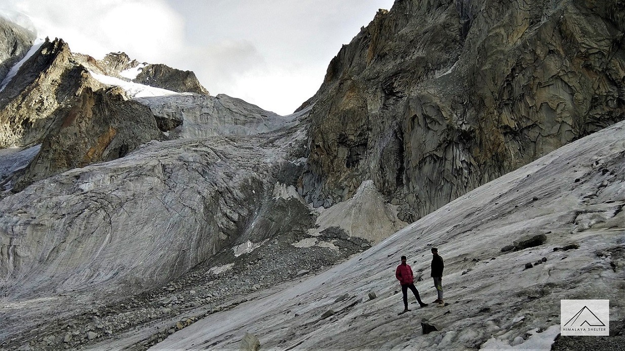
Forming a bridge between two most important Hindu pilgrimage sites, Kedarnath and Badrinath, at an elevation of 4,200 meters, the Panpatia Col is one of the high-altitude mountain passes that gets across the Panpatia Glacier. It is surrounded by several major peaks of the Garhwal Himalayan region. From the group of 6 thousanders, the Nilkantha at an elevation of 6,596 meters is the most prominent one. Nonetheless, the peaks of Balakun at 6,108 meters, Kunaling at 6,471 meters, Januhut at 6,495 meters, Shri Parbat at 6,175 meters and Chaukhamba group and several other 5 Eight-thousanders are visible throughout the trail from Badrinath to Ransi.
The Panpatia Col trek that further traverses through two other high altitude mountain passes, several moraines, gushing streams and narrow cliffs is one of the toughest treks in the Garhwal Himalayan region. It was once the mythological route on which pilgrims used to trek from Kedarnath to Badrinath in 1 day. The route was lost in time but few demented explorers re-discovered the route and led it in the trekking map of the Garhwal Himalaya. The journey is further enriched with several picturesque campsites beside the pristine water of several lakes. Rich alpine meadows dotted with varied species of Himalayan flowers are a common site. The Panpatia Col Trek requires some serious acclimatization at certain altitude and is recommended only to trekkers who have prior high-altitude trekking experience.
The trek from Badrinath and heads to Dumkal Kharak and thereafter turns to Nilkanth Khal, which is at an altitude of 4,650 meters. The journey thereafter turns to the snout of Panpatia Glacier and later winds to the glaciated track to further climb towards Panpatia plateau. Thereafter crossing Panpatia Col, the trail leads to Maidagala Tal. The downhill trek continues to Madmaheswar and then leads to Ransi. The best time to hit the trekking tracks to Panpatia Col is during the summer and autumn seasons.
Days 1–4: Approach & Acclimatization
Day 1: Dehradun → Joshimath (by road; overnight hotel stay)
Day 2: Joshimath → Badrinath → Shepherd Camp
- Morning drive to Badrinath, temple visit, then a 20‑minute trek to base camp. Overnight in tents.
Day 3: Shepherd Camp
- Trek along ridgeline up to tree line to the Shepherd campsite.
Day 4: Shepherd → Snout Camp
- Moderate ascent across mixed terrain leading to the snout (start) of the Panpatia Glacier.
Days 5–8: Glacier Traverse & Summit Push
Day 5: Snout → Moraine Camp (4,300 m)
- Gentle climb over glacial moraines with stunning Himalayan vistas.
Day 6: Accommodation & Rest at Moraine Camp
- Acclimatization day—rest or light walks around camp.
Day 7: Moraine Camp → Parvati Col Base
- Short steep ascent, reaching the base of Parvati Col below the glacier.
Day 8: Base → Panpatia Snowfield Camp (5,150 m)
- Climb steep gully (rock + snow), rope-assisted sections, camp atop the vast snowfield with views of peaks like Chaukhamba.
Days 9–13: Summit, Descent & Departure
Day 9: Snowfield Camp → Panpatia Col (5,260 m) → Sujal Sarovar (4,750 m)
- Traverse snow plateau, ascend to the col, then descend to a serene campsite by Sujal Sarovar (small lake).
Day 10: Sujal Sarovar → Kachni (4,159 m)
- Ascend to a small pass above the lake, then down boulders and snow to rolling meadows overlooking Madhyamaheshwar Ganga.
Day 11: Kachni → Nanu Chatti (3,250 m)
- Trek through oak forests to Madhyamaheshwar temple, then follow a mule track to Nanu Chatti.
Day 12: Nanu Chatti → Ransi → Rudraprayag
- Walk down through pine forests alongside the river to Ransi, then drive to Rudraprayag.
Day 13: Rudraprayag → Dehradun
- Return drive concluding your trek adventure.
In Himalaya Shelter, we provide you with the option to customize your Panpatia Col trek experience. Whether you're an avid mountaineer, an adventure seeker or a group of friends, you can opt for our personalized tailor-made expedition program. This customized program will be exclusively designed for you, taking into account your specific requirements for transportation, accommodation, meals, technical equipment and any other premium facilities you may need during the climb.
Starting from Dehradun (pick up point), the Panpatia Col trek passes through scenic destinations and reaches Joshimath and then Badrinath. From here, you start your actual expedition.
Himalaya Shelter ensures your journey is safe and memorable with experienced local guides, technical support and all necessary permits. You can even request offbeat routes or sunrise hikes for a more immersive Himalayan experience.
Moreover, no other participants will be added to your group. Choosing a customized program will enable you to enjoy your journey without any hesitation.
Panpatia Col trek is named after Panpatia glacier and Panpatia Pass. Panpatia Pass was believed to be part of divine trail used by deities, gods and sages to connect Char Dhams, especially Kedarnath and Badrinath. Locals believe that Panpatia glacier was once travelled by Sage Vyasa who was the writer of epic Mahabharata. During his travel from Badrinath to Kedarnath, he followed this difficult route of Panpatia glacier because he wanted to avoid human settlements and distractions for seeking solitude and getting divine inspiration. Probably, this belief gave this name 'Panpatia' which possibly derived from 'Panch Pratha' (the five paths) which symbolizes the mystic routes of sages.
The region nearby Panpatia Col remained unexplored and isolated for a long time due to the difficulties of terrain. Only shepherds communities like Gujjars and Bakarwal used these routes for their seasonal migration. Though the region was notably used for spiritual and meditation practices by sages and hermits, the connecting route between Kedarnath and Badrinath is still considered mythical or not confirmed.
By the end of 20th century, when tourism started growing within India, some explorers tried to rediscover this mythical connection between Kedarnath and Badrinath. In 2002, a team led by Harish Kapadia, a veteran Indian mountaineer, successfully navigated this difficult pass. His explorations confirmed the possibility of connecting routes between two holy shrines, Kedarnath and Badrinath. Since then, Panpatia Col trek has become the most challenging non-technical treks in the Indian Himalayas.
Crossing the Panpatia Glacier and Col (5,200 m):
Panpatia Col trek involves traversing the massive Panpatia glacier and crossing the Panpatia Col at over 17,000 ft. These activities are very challenging but bring adventure with them. Trekkers usually enjoy their experiences of crossing them with icefalls and unpredictable weather. It also serves as a true test of trekkers' mountaineering skills and mental and physical endurance.
Remote and Unexplored Terrain:
Though Panpatia Col trek is very popular among mountaineers and trekkers, still remains largely unexplored. Due to its difficult terrain, remote valleys and high-altitude snowfields, less trekkers come here and that too experienced ones. In short, the trek is not crowded. The trail passes through places like Madmaheshwar, Sujal Sarovar, Parvati Gully which are holy and barely documented. They offer raw Himalayan wilderness to trekkers.
360-Degree Views of Majestic Peaks:
Though the entire trekking journey to Panpatia Col is very rewarding, the 360-degree views of prominent Himalayan peaks like Nanda Devi, Chaukhamba, Neelkanth and Hathi-Ghoda Parvat give you an unforgettable experience. You will also pass through sacred lakes like Sujal Sarovar and spiritual vistas like Madmaheshwar along the route. This is so surreal to view this great panorama which is combined with raw nature and spirituality.
Mesmerizing Himalayan Flora and Fauna:
Panpatia Col trek includes lush forests to barren glacial zones. It offers a rich biodiversity and changing ecosystem. At lower altitudes, especially near Joshimath and Khirao you will see blooming red rhododendrons and maple, birch, deodar, blue pine trees. Wildflowers including blue poppies, primulas, anemones and edelweiss are full-bloomed in summer season. Also, the rare Himalayan wildlife like tahr, musk deer, blue sheep, monal and snow leopard (very rare but this region falls within its known habitat) may be spotted
Panpatia Col trek is considered one of the most challenging treks in the Indian Himalayas. It is suitable for seasoned trekkers with having high-altitude experience. The elevation range of Panpatia Col trek is from 2,700 m to over 5,260 m for which acclimatization is very crucial for trekkers. This trek is not suitable for beginners, kids and families.
The terrain of Panpatia Col trek is a mix of dense forests, boulder-strewn paths, steep climbs, glacial moraines, crevassed snowfields and high mountain passes. Trekkers have to encounter unstable rocks, long icy stretches and perilous ridgelines. The trail connects Badrinath to Kedarnath through remote and isolated alpine regions.
The trek takes 12 to 15 days to complete. Daily walking hours duration is from 6 to 9 hrs, often in challenging conditions. One of the major challenges is crossing Panpatia glacier and navigating through high snowfields. Whiteouts and sudden weather changes can add other challenges. Night temperature can go below -5°C and heavy rainfall and hailstorms can occur unexpectedly.
Due to the technical nature of the trek, support of an expert guide or joining a team is mandatory. Usage of equipment like crampons, ropes, ice axes are essential. River crossings and crevasse navigation demand technical help. Emergency evacuation is complicated and requires satellite communication due to no network coverage.
Overall, Panpatia Col is a highly challenging but highly rewarding trek that requires physical and mental endurance, high stamina and professional support.
The best time to trek in Panpatia Col is from May to June and from September to early October. These windows offer the most favourable time, stable weather and manageable snow level.
- May to June
From May to June, the trails are filled with snow bridges and melting glaciers. Snow can still be present, especially near Panpatia Col. It adds some adventure but trails can be slushy. However, the meadows are lush green and filled with blooming flowers. The sky is clear and visibility is good. Daytime temperature range goes between 10°C to 15°C at lower camps like Badrinath or Khirao. On higher camps like Sujal Sarovar and Panpatia, temperature can be around 0°C to 5°C. At night time it can dip to -10°C or below. Be prepared for extreme cold.
- September to Early October
This time landscapes come alive and fresh with more greenery after monsoon. Trails are dry but at higher altitudes, snow can still be present. The sky is clearer and mountain peaks like Neelkanth, Parvati Peak and Nanda Devi are easily visible. Valleys glow with the golden hue of autumn. During this time, daytime temperature remains around 8°C to 12°C at lower altitudes. Around Panpatia Col, it's around 0°C to 4°C. At night time it can go below –8°C. Try to complete your expedition by mid-October. Snowfall may begin by late October.
Note: Avoid July to August due to heavy rainfall which makes trails slippery and prone to landslides. Similarly winters (November to April) are not suitable due to heavy snowfall and cold temperatures.
Trekking to Panpatia Col involves journey through road travel and trekking in Himalayan terrain. The pick-up point is usually Dehradun, Rishikesh or Haridwar. All are well-connected by road and train to major cities of India.
You can also travel by flight to Dehradun. Dehradun’s Jolly Grant Airport is the closest airport from Rishikesh and Haridwar. From Haridwar or Rishikesh, you can hire a taxi or bus to Joshimath which is about 270–290 km away and takes around 9–10 hrs by road. Joshimath is the base town where trekkers usually rest and prepare for Panpatia Col expedition.
The actual trek starts from Badrinath or Karchi village, depending on chosen route. Badrinath is approx 45 km from Joshimath and can be reached via a scenic drive. From here, the trail passes through remote regions like Shepherd Camp, Snout Camp, Moraine Camp and Panpatia Snowfield before finally crossing the high-altitude Panpatia Col (5,260 meters).
The trek generally ends at Madhyamaheshwar or Ransi village, depending on the exit route.
Due to its high altitude, glacier crossings and rugged terrain, Panpatia Col trek is not connected by any direct public transport after Joshimath or Badrinath. All logistics beyond these towns such as porters, guides, food and camping equipment, must be arranged in advance through a trekking agency.
The entire route falls in a remote, alpine zone with no mobile connectivity or road access, so proper planning and local support are crucial.

Mandatory Backpacking List for Aancha Top Trek
Clothing and Backpack
Get a good backpack (50 L) with a rain cover. Look for a bag that can provide you good back support. Pack 4 quick-dry t-shirts and 2 trekking pants. Get a pair of thermals (upper and lower) for night. Pack a fleece jacket or woolen sweater as a mid-layer. Get a waterproof wind breaker for sudden rain and chilly winds. For winter trekking, get a good down jacket. Now pack a woolen beanie and a balaclava. Get two pairs of gloves (woolen and waterproof). You should also pack a suncap for the daytime.
Footwear
You should look for good quality trekking shoes. Your shoes must be waterproof and provide good ankle support. Do not wear a new pair of shoes on the trek. Your feet must be familiar with the shoes. Now pack 4 pairs of trekking socks and 2 pairs of woolen socks. Pack a pair of comfortable slippers or sandals for the campsite.
Personal Care
For personal care items, start packing with your toiletries. Get a small zipper pouch and pack all the toiletries. Now look for a quick-dry towel and a toilet roll. You should also pack hand sanitizer and moisturizer. Pack a sunscreen that can protect your face from sunburn. You can also pack some snacks for the trek.
Physical Fitness Preparation for Trek:
To overcome the difficulty level of trekking, it requires strong cardiovascular endurance, muscular strength, and overall physical fitness. Incorporate these exercises into your routine to increase strength, stability, and stamina, which will help you tackle difficult terrain sections of the trail at high altitudes.
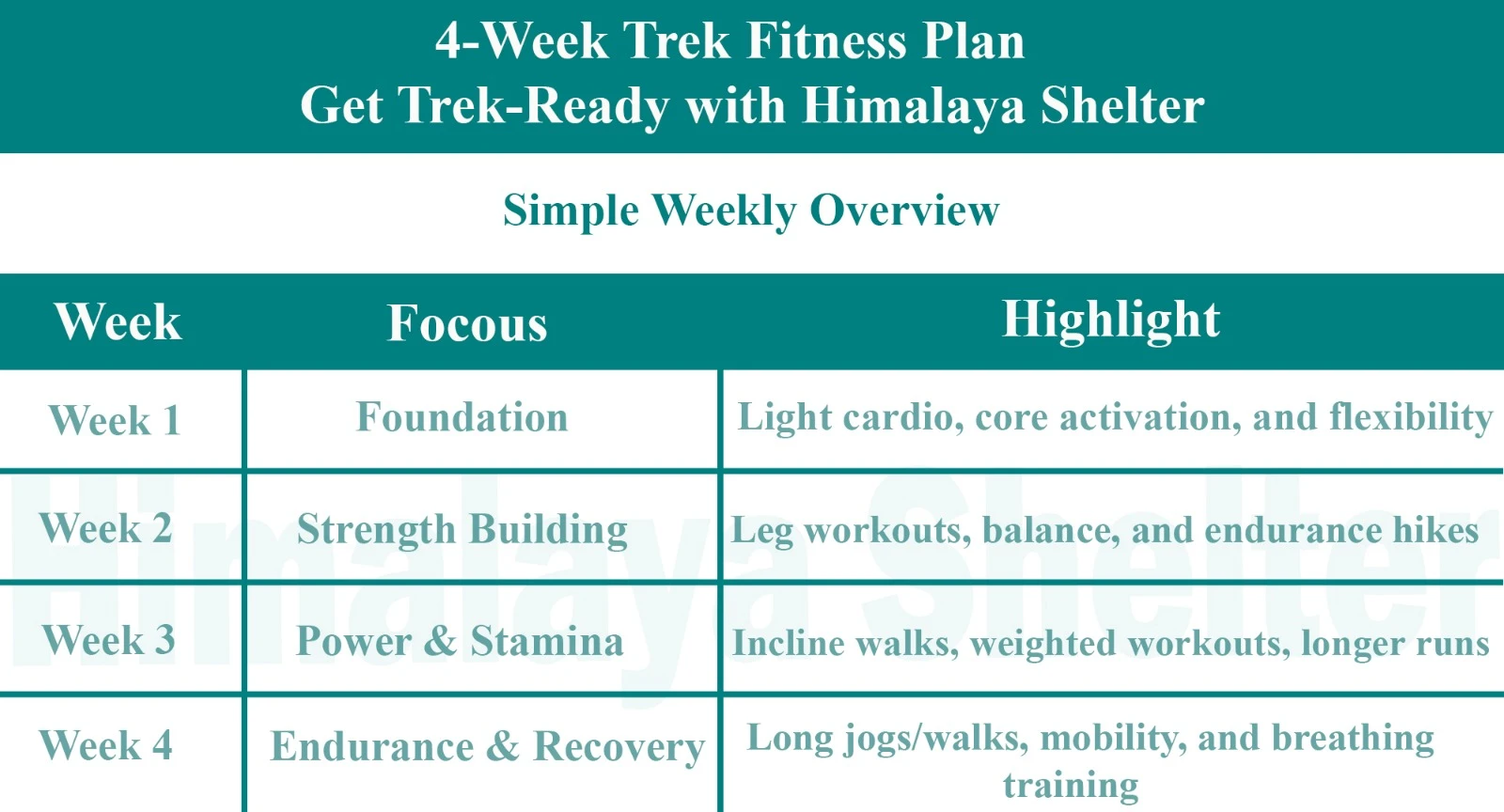
Overview

Foundation

Strength Building

Power & Stamina

Endurance & Recovery
Day 1: Dehradun to Joshimath (1875 m)
In the morning after having breakfast, we will drive to Joshimath. On the way, we will halt at a restaurant for the lunch. We will be staying overnight at a hotel in Joshimath.
Day 2: Joshimath to Badrinath (3133 m)
Today after having breakfast in the morning, we will drive towards Badrinath. We will visit the prominent Badrinath Temple and trek for about 20 minutes to reach the campsite. Overnight stay will be camp.
Day 3: Badrinath to Shepherd Camp
On this day, we will trek towards the Shepherd Camp. We will ascend up to the tree line, which is marked by flags on the boulders. After trekking for a while we will reach our campsite which is situated at a position from where one gets spectacular views of the surroundings.
Day 4: Shepherd camp to Snout Camp
Today, we will be trekking on a combination of terrains. During the trail, we will take a moderate uphill hike to precipitous climbs in order to reach the snout of the spectacular Panpatia glacier.
Day 5: Snout camp to Moraine Camp (4300 M)
The trek today, although of longer duration, has a very gentle ascend. We will cross the moraines and traverse the patches of snow. Our reward for today’s trek will be the fabulous views of towering Himalayan Mountains. We will be staying for the night in the Moraine Camp.
Day 6: Rest & Acclimatize (4300 M)
This entire day kept for having some rest and acclimatization.
Day 7: Moraine Camp to Base of Parvati Col
Our next trekking destination will be the base of Parvati Col. To reach Parvati Col. we will pass through the Panpatia Snow Field. The trekking pathway involves precipitous inclines. We will be camping just below the Parvati Col.
Day 8: Base of Parvati Col to Panpatia Snowfield - Camp
After having a wholesome breakfast, we will move ahead and climb to the edge of the terrace from where the only way to go upwards is through a vertical gully which is covered with rock and snow. From the spot, we will be able to see the magnificent Chaukhamba Peak and if fortunate enough we might also see the captivating Nanda Devi Peak. We will be staying for the night in the Panpatia Snowfield.
Day 9: Camp I to Across Panpatia Col (5260 M) to Camp at Sujal Sarovar (4750 m)
On this day of our trek, we will pass through a snow plateau to reach Panpatia Col (5260 M). Moving ahead is a precipitous descent that will lead to the Madhyamaheshwar watershed. We will be camping overnight beside the small lake of Sujal Sarovar.
Day 10: Sujal Sarovar to Kachni
We will start our trek towards Kachni. To reach Kachni we will trek through sloped and rock-strewn zones through a small pass located above the Sujal Sarovar. After trekking for some time, we will reach our camp site. The campsite faces the Madhmaheshwar Ganga, and also from here one can see the temple below and the lights of Guptkashi.
Day 11: Kachni to Nanu chatti
On this day, we will trek to the Madhmaheshwar temple, which will take around 3 to 4 hours. We will visit the temple and will have lunch at a nearby tea shop. After having lunch, we will hike through the forests to our camp situated at Nanu chatti, which is a small settlement of the summer homes for people from the villages of Gaundhar. Overnight stay in camp.
Day 12: Nanu Chatti to Ransi & drive to Rudraprayag
Today is the last day of trekking. On this day, we move downwards passing through the dense pine forests to arrive at the bank of Madhmaheshwar Ganga. At Ransi our trek will end and from this location, we will drive towards Rudraprayag. Overnight stay will be in a hotel at Rudraprayag.
Day 13: Rudraprayag to Dehradun
After having a wholesome breakfast, we will drive to Dehradun.
Our treks are specially designed by the experienced team at Himalaya Shelter, taking you on an adventure of a lifetime all while making you connect not only with the bountiful nature but also with yourself and with others on the trek with you creating wonderful memories which will last you a lifetime. All Himalaya Shelter treks are guided by experienced Trekkers having vast knowledge and experience of the region, providing with insightful information and stories pertaining to the region’s flora and fauna and the history of the region whilst the trek. It is safe to say that on successfully completing the trek, one will gain tremendous insight and experience along with lifetime memories.
Trek Inclusions
- Transportation support Dehradun
- Accommodation – At Base Camp, stay at a local homestay or guest house for one night each, which will give you an insight into the authentic lifestyle of the locals.( INR 5000 per person extra for single sharing throughout the trek )
- On Trek stay in a 2-person Vango Halo Pro/A-Shape tent, which is to be shared by two trekkers, built to withstand extreme weather conditions and at the same time making you comfortable after a hard day’s trek.
- Camping Equipment – specially designed sleeping bags that can withstand harsh weather conditions, foam mattresses. Other safety gear like microspikes, gaiters, an ice axe, and helmets will be provided.
- Medical Kit – our team will be equipped with an extensive medical kit, which our team is trained and experienced to use. Oxygen cylinders are used after they are thoroughly inspected throughout the Trek. Even campsites have large oxygen cylinders as backups.
- Permission - Forest entry charges for Indian nationals (Additional charges will be applicable for international tourists)
- Meals – Breakfast, packed lunch (on trek days), evening snacks, and dinner will be served. A hearty, delicious, and nutrition-filled Veg meals with egg preparation will be provided throughout the trek. (Jain and Vegan Food can also be arranged on prior notification.)There will be a dedicated Kitchen Tent along with a dining tent, which will have a dining table too.
- Our Team – A highly experienced and AMC-certified Trek Leader who will help ensure that the entire trek goes smoothly and safely while navigating the challenging conditions during the trek, and is skilled enough to navigate any medical emergency that can arise during the trek. Local and route Guides who are well-versed with the region and provide an in-depth insight into the local customs and knowledge of the flora and fauna endemic to the region. A dedicated Kitchen staff, which includes a Cook, a helper, and other support staff.
- There will also be porters and mules to carry common equipment.
- Cloakroom - We have a cloakroom facility available for extra luggage. Every trekker is permitted to leave their luggage behind at no charge.
Trek Exclusions
- Personal expenses like tips, personal medicines, phone calls etc.
- Travel Expenses - Travel expenses from your hometown to the mentioned Pick-Up Point are not included in the trek fee.
- From the scheduled pick-up spot to the base camp, we have our own fleet of vehicles like Bolero, Innova, Dezire, or Tempo Traveler (12-seater). This is be shared by trekkers for a pre-decided amount. All vehicles are non-AC.
- Personal Equipment - Any personal gear like jackets, shoes, cutlery, or backpacks are not included in the trek fee. We recommend renting them from our Rental Store for an affordable fee. This can be pre-arranged to avoid last-minute hang-ups.
- Offloading - We encourage carrying your backpack to get into the true spirit of trekking. However, if needed, you can opt to offload your personal luggage of up to 12 kgs for an additional cost of INR 350 per bag per day.
- Trek Insurance - A mandatory trek insurance fee is charged in addition to your trek fee. Since most medical insurance doesn’t cover adventure activities, trek insurance offers essential coverage, enhancing your safety without a significant financial burden.
- Buffer day on the trek - We have kept a buffer day on the trek to account for any weather-related delay. If this is utilized, you will need to pay an extra amount to your trek leader.
- Anything apart from inclusions.
Please carry a lunch box for a packed lunch/breakfast to avoid using polythene and Aluminium foil.
Keeping the Himalayas clean is our own responsibility. Reduce the use of Plastic when you are in the abode of the Sacred Himalaya. 🌱
The Panpatia Col Trek has an 8/8 difficulty rating making it a very challenging trek. This trek is extremely difficult and requires a high level of endurance stamina and physical fitness. It is highly necessary for trekkers to have prior trekking experience in an area with high elevations of 4500–5000 feet.
Each persons average cost for this trek ranges from Rs 90000 to Rs 175000. The size of the group the services needed and the trekking teams and guides experience all affect the price. For overseas trekkers the price will be greater.
One of the hardest and most difficult treks in the Garhwal Himalayas is the Panpatia Col trek which connects the sacred pilgrimage sites of Kedarnath and Badrinath. At an astounding 5260 meters (17260 feet) above sea level this high altitude pass is situated between two unnamed peaks that are more than 5500 meters high. h. Situated between two unnamed peaks that are more than 5500 meters high this high altitude pass is an astounding 5260 meters (17260 feet) above sea level.
The Panpatia Col Trek stands out for linking Badrinath and Kedarnath, two foremost shrines of the Hindu religion, through a historic glacier pathway. It is equally renowned for its Koukhamba, Nilkanth and Parvati peaks as well as the Upon of Heaven myth encircling the course.
If feeling fortunate, wildlife enthusiasts can spot the snow leopard, the Himalayan blue sheep, and musk deer. Closer to the base, there are forests of rhododendron, while alpine meadows and glacier landscapes dominate the higher altitudes.
May–June and September–early October.
Yes, with proper permissions and gear.
Yes, Madmaheshwar Temple and Panpatia Glacier are spiritually significant.
Forests, boulder fields, glaciers, snow slopes and steep ridges.
Nights can go as low as -5°C to -10°C.
No, it’s only for seasoned trekkers.
It's believed to be the mythical route walked by the Pandavas from Kedarnath to Badrinath.
Read More on Panpatia Col Trek
Treks by Categories
Treks By Month

Treks By Experience

