The Dafeybhir Pass Trek

Duration
10 Days
Trek Altitude
15015 Feet
Destination
Sikkim
Trek Distance
63 Kms
Group Size
Private
Best Time
Spring And Autumn

THE DAFEYBHIR PASS TREK

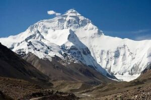
Trek Overview An untouched trail in Sikkim – the Dafeybhir Pass Trek, close to the Indo Nepal border offers majestic views of the Sikkim and Nepal mountains which includes Everest, Lhotse, Makalu and Kanchenjunga. This offbeat trek was introduced by the legendary mountaineer Tenzing Norgay Sherpa goes over steep rocky terrain, green valleys and one of the best things is also the azure lakes near the pass. The Dafeybhir Pass is also known as Danphebir La or Dafeybhir La is a high altitude pass at about 15000 ft. Sikkim has a very different landscape. This trek has flowing rivers, up close mountain views, extremely steep ascents and descents and beautiful forests of oak, bamboo, fir and rhododendrons which makes it very beautiful however challenging as well. The terrain is tricky consisting of rocks and boulders and one gains altitude quite quickly. The campsites get cold and with the altitude, we recommend this trek to experienced trekkers who have done at least a couple of high-altitude treks. The trail starts from a small village close to the Nepal border in West Sikkim called Uttarey at an altitude at about 6600 ft. The trail continues along the Singalila ridge which borders south west Sikkim and the Nepal border and then enters Sikkim again ending in the Upper Nombu region in West Sikkim.    

Itinerary

  • Distance: 160 kms drive
  • Time taken: 7 hours

The drive from the airport/railway station starts by entering a flat forest section for a few kilometers, leaving the hustle bustle of the city, one starts breathing fresh air.

The roads wander through the two famous rivers of West Bengal and Sikkim – Teesta and Rangeet, the trekkers can witness the confluence of these rivers at the Melli Check Post where the two states meet as well.

Once we cross the Melli Check Post we enter Sikkim and get our chance to taste the local delicacies like thukpa, momos, thenthuk and others.

A few hours later we pass through two wonderful cities of Sikkim – Geyzing and Pelling which are known for the monasteries and delicious local food. If time permits, the trekkers can take a quick walk and shop for essential/last minute supplies.

  • Trek Distance: 6.20 kms
  • Time: 6 hours
  • Altitude: 6400 ft to 8670 ft

We take the roadhead from Uttarey today and trek along the Sapa Khola stream, pass a trout fish farm and then reach a man-made trail. We walk for a few more kilometers and reach the start of the Barsey Rhododendron Sanctuary.

As a trekker, the rhododendron flowers and forests are a visual treat, the forests blooming with flowers in the months of spring is something else.

As we enter the sanctuary the trail gets steeper. One can spot different birds and plants that are special to this region.

After crossing a few bridges, we ascend to Chittrey.

  • Trek Distance: 6.50 kms
  • Time: 8 hours
  • Altitude: 8670 ft to 11410 ft

Be mentally and physically prepared to ascend all day today. We start with a sharp ascent through forests and pass another SSB camp – Nepal Police Check Post and a Forest Rest House at Chewabhanjang.

From Chewabhanjang we keep ascending and you will get to know that now we are trekking on a ridge with amazing views of the mountains and valleys.

After ascents and descents, we reach Viewpoint 1 where one can rest for a bit and get a glimpse of the Sleeping Buddha.

We shuffle between India/ Nepal and another three and a half kilometers of trekking gets us to our campsite for the day – Gairi.

  • Trek Distance: 6.50 kms
  • Time: 8 hours
  • Altitude: 8670 ft to 11410 ft

Today the terrain is gentle and easier than yesterday. We follow the trail on the ridge to the north. Continuing on the trail for about four and half kilometers we reach Dhoor, our campsite for the day.

  • Trek Distance: 8 kms
  • Time: 7 hours
  • Altitude: 12300 ft to 12645 ft

We walk mostly on the ridge today like yesterday all the way up to Pahadimegu. At this altitude and above in the spring season the dwarf rhododendrons are in full bloom.

The trek time today is about 7 hours and as we gain altitude we camp and prepare for the cold, stay warm in the tents by the time the sun sets.

  • Trek Distance: 7.2 kms
  • Time: 9 hours
  • Altitude: 12645 ft to 14205 ft

From today onwards we prepare ourselves to trek for a long distance on terrain which keeps changing and the altitude keeps increasing. Trekking alongside the valley, most of the trail is inside Nepal. As we climb higher the trees start fading and we are above the tree line.

As we reach Lampokhri Lake we see a trekkers hut and now we are in the alpine lake zone.

On reaching the campsite, the crystal-clear waters are a sight to behold. The water is so clear that one can see the bottom of the lake. Camping above 14000 ft is a thrilling experience in itself. Be prepared for the cold and freezing temperatures.

  • Trek Distance: 9.4 kms
  • Time: 12 hours
  • Altitude: 14205 ft to 15015 ft and back to 14205 ft

Today we trek to the highest point, it can be tiring however we promise it to be the most rewarding as you see three more alpine lakes and Mount Kanchenjunga, the whole family of mountains up close.

We start early morning (4:30 am) to reach the Dafeybhir pass by sunrise. From the campsite, the pass is about one and a half kilometers which will take about an hour and a half to reach the top.

A view that you will always remember and after all the hard work of getting to the pass, it is very rewarding and humbling. The lake appears to be floating in the clouds, the Sleeping Buddha in all its majesty. Below us we can see the twin lakes of Zumley Pokhri.

  • Trek Distance: 9.4 kms
  • Time: 7 hours
  • Altitude: 14205 ft to 8155 ft

From Lampokhri we take the opposite side to descend to Naya Pataal. Now we start descending and do this so over 9.5 kms, even though it is downhill take it as slow as you can and give your knees some rest. We enter forests after 5 kms and feel the freshness of the forests and trees around after walks on the ridge for all these days.

Another four kilometers through the forest, we see a few huts across. We pitch our tents next to the stream. We get a good rest after a long descent.

  • Trek Distance: 5.2 kms
  • Time: 5 hours
  • Altitude: 8155 ft to 5560 ft

Today a steep descent takes us to Senkhola. We cross through makeshift bridges and come across bamboo and fir trees. Not too long the trail, about 5 kms and pretty. The river flows along with us.

  • Trek Distance: 155 kms
  • Time: 7 hours

Drive back and enjoy the journey along the mountains of beautiful Sikkim. We will drop you back to NJP railway station / Bagdogra airport.

Reviews

Inclusions
  1. Stay is included from Day 1 to Day 9 (Uttarey to Senkhola). You will be staying in a guest house at the base camp, Uttarey. The rest of the days will be camping on the trek.
  2. All trek permits and camping charges are included.
  3. All meals from dinner at Uttarey on Day 1 to breakfast at Senkhola on Day 10 are included. We provide simple, nutritious vegetarian food on all days of the trek.
  4. Gaiters, Microspikes, when needed
  5. Camping Equipment including tents, kitchen & dining tents, toilet tents etc
  6. Certified Trek Leader, Cook and Support Staff
Exclusions
  1. Anything is is NOT mentioned in the “Inclusions” or personal expenses.