
Parang La Trek
6 Lakh+
Satisfied Trekkers
16+
Years of Experiance
1300+
Google Reviews
800+
Tripadvisor Reviews
Duration
13 Days
Difficulty
Difficult
Max Altitude
18,300 ft/5500
Region
Ladakh | India
Pickup
Manali
Best Season
Monsoon
Quick Information
Trek Duration
13 Days
Trek Difficulty
Difficult
Trek Group Size
5-6 max
Trek Distance
128 km
Trek Max Altitude
18,300 ft/5500
Trek Region
Ladakh | India
Trek Pickup
Manali
Best Season
Monsoon
Best Time
July, September
Trek Basecamp
Himachal Pradesh
Trek Backpack Fee
₹ 500
GST Fee
5%
Parang La Trek Overview
Parang La Trek is a mesmerizing and thrilling trek. This is a very challenging trans-Himalayan. You start your trek from the cold desert of Spiti and walk to the beautiful land of Ladakh. The Parang La is a high-altitude pass that connects Spiti to Ladakh.
The trek is very difficult but has some of the most beautiful landscapes. This journey is a pure adventure and an experience of raw nature. You will walk on the rugged terrain in a very remote area. Your Parang La Trek will start from Kibber. This is a beautiful high-altitude inhabitant village. You will start ascending the rugged mountains alongside the Pare Chu River.
The landscapes in the trek are unmatched. You will start from rugged mountains and then walk through meadows and glacial fields. The most challenging part of the trek is crossing Parang La. You will walk on the moraines and icy stretches. But the views from Parang La are outstanding.
The sunrise and sunset on the big snow-capped mountains are majestic. You will be surprised with the beauty everyday. The most beautiful landscape of the trek is the Tso Moriri Lake. This beautiful lake is located at 15075 feet. The turquoise water surrounded by big mountains feels majestic. The Parang La trek gives you a true sense of achievement.

More Information
Parang La Trek Short Itinerary
Day 1: Arrival in Manali | Guesthouse
Day 2: Drive from Manali to Kaza(200 km) | Homestay
Day 3: Rest at Kaza
Day 4: Drive from Kaza to Dumla(24 km) | Alpine Tents
Day 5: Trek from Dumla to Thaltak(6 km) | Alpine Tents
Day 6: Trek from Thaltak to Base Camp Bonjrojen(9 km) | Alpine Tents
Day 7: Trek From Base Camp to Kharsa Gongma via Parang La(11 km) | Alpine Tents
Day 8: Trek from Kharsa Gongma to Thakta(18 km) | Alpine Tents
Day 9: Trek from Thakta to Rancholamo(16 km) | Alpine Tents
Day 10: Trek from Rancholamo to Kitpodasu(9 km) | Alpine Tents
Day 11: Trek from Kitpodasu to Kiangdom (14 m) | Alpine Tents
Day 12: Drive from Kiangdom(4588 m) to Karzok(30 km) | Homestay
Day 13: Drive from Karzok to Leh(211 km)
Parang La Trek Itinerary
Stay at Manali
Altitude: 2050 m
Accommodation: Homestay/Hotel
Meal: Dinner
Your Parang La journey begins with your arrival in Manali. Once you reach Manali, check in to your homestay or hotel and take some time to rest after the journey.
Manali is situated in the Beas River valley and is surrounded by the lush mountains of Himachal Pradesh. You can spend the rest of the day relaxing and exploring the nearby area at your own pace.
Since the upcoming trek takes you to high altitudes, use this day to rest well and prepare for the journey ahead. Keep yourself hydrated and avoid exhausting activities.
In the evening, you will have dinner at the accommodation and meet your trek team. Your trek leader will brief you about the upcoming days, route, weather conditions, equipment and other important details.
Overnight stay in Manali.
Drive Distance: 200 km
Altitude: 3650 m
Accommodation: Homestay
Meal: Breakfast+Dinner
The journey to the Parang La trek begins with a scenic drive from Manali to Kaza. Covering approximately 183 km, the drive takes around 7–9 hours and passes through some of the most dramatic landscapes in the Himalayas. En route, you cross the Atal Tunnel, traverse the rugged terrain of Gramphu and Batal, and ascend the iconic Kunzum Pass. As you descend into Spiti Valley, the scenery transforms into a stunning cold desert with barren mountains and wide open valleys. Upon reaching Kaza, you can relax and begin acclimatising to the high altitude in preparation for the days ahead.
Acclimatisation Day
Meal: Breakfast + Lunch + Evening Snacks Dinner
Today is a rest and acclimatisation day in Kaza. After reaching an altitude of around 3,650 m, this day gives your body time to adjust to the increasing altitude before you move towards the higher camps of the Parang La route.
You can spend the day taking short walks around Kaza and exploring the local surroundings. You can also visit some of the nearby monasteries. Key Monastery, one of the most well-known monasteries in Spiti Valley, is located a short drive from Kaza. You can also visit Sakya Abhayagiri Monastery, located near the main market area of Kaza.
Kaza is the largest town in the Spiti Valley and is surrounded by dry, barren mountains. You can explore the local market, walk around the town and observe the traditional architecture of Spiti. This is also a good opportunity to try some local Spitian food. You can try dishes such as thukpa, momos, tingmo and traditional Tibetan-style food available at local cafés and restaurants.
Your trek leader will also brief you about the upcoming trekking days, including the route, weather, water availability, altitude and important safety instructions.
Make sure you drink enough water throughout the day and eat properly. A good night's sleep will help you prepare for the next day's drive towards Dumla.
Tip: Do not push yourself today. Keep your walks short and comfortable, as the purpose of the day is to allow your body to acclimatise gradually before gaining more altitude.
Drive Distance: 24 km | Altitude: 4200 m
Accommodation: Alpine Tents
Meal: Breakfast+Lunch+evening snacks+Dinner
This 24 km drive is going to be very interesting because, first, you will see Kibber - the world’s second-highest motorable village. And then you will cross Chicham bridge - Asia’s highest bridge. The drive covers some traditional villages of Spiti with unique houses. The houses have a similar architectural style, with whitewashed walls and small details in red, blue and black. Against the yellowish and brownish shades of the surrounding Himalayas, these bright houses stand out beautifully.
Dumla is an open campsite near Chicham and Kibber village. It is just 8 km from Kibber. Farms of Peas and barley surround the campsite and it has a wide view of the barren Himalayas. The altitude of the camp is 4200m. From the campsite, the starting trail is visible, which creates more excitement.
Trek Distance: 6 km
Altitude Gain: 4200 m to 4600 m
Accommodation: Alpine Tents
Meal: Breakfast + Lunch + Evening snacks + Dinner

The actual trek starts from Dumla. First, the trail goes up, and then it becomes gradual. As you ascend the very first section, you can see the beautiful villages of Kibber and Chicham. This section of the trail also passes through habitat where wildlife can be found. With some luck, you may spot animals such as the Himalayan fox, wolf or blue sheep. Keep your eyes open and maintain a respectful distance if you encounter any wildlife. The trek is not difficult on day 5. The walk is mostly on the field. You will see bushes that are covering the field, which is caragana versicolor, a hardy shrub adapted to the cold and dry conditions of the Trans-Himalayan landscape.
The most famous trekking peak, ‘Kanamo’ is also visible. Now the views of the trans Himalayas are wider, more serene and deeper. It will literally feel like you are going deeper.
After walking 6 km, you reach Thaltak campsite. The campsite has alpine meadows. It is the place where you can see a large herd of Blue Sheep and Yak. And the campsite is near that Himalayan deep gorge, the gorge on which the Chicham bridge is built. And that geographical landform of orange shade looks very exciting. Here, your excitement will increase because the trail further is from that gorge. People usually stand on that bridge, but you will go to the bottom to see how interesting it feels.
Trek Distance: 9 km
Altitude : 4600 m to 5075 m
Accommodation: Alpine Tents
Meal: Breakfast+Lunch+Evening Snacks+Dinner

Wake up with the call of snowcocks. The day is going to be demanding and exciting both because the trail is going to Bonjrojen, which is Parang La Pass Base Camp. The trek starts downhill till Parilung Bi River, which is around 600 m down. The descent is a rock fall zone, so be careful while trekking, and the trail goes down in a zigzag pattern. While walking into the gorge, it feels incredible; the geography of the narrow gorge and the orange shade of the hills both together are fantastic.
Then, for some miles you walk with that river and then trail uphill and take a turn to the left side to base camp. The trail has scree, and it is narrow. Bring enough water because it is going to be very sunny, while water becomes increasingly scarce and your lungs will give you the realisation that you are above 4500 m and in a cold desert.
After some kilometres, the base camp arrived. The campsite feels quite peaceful. The water comes here under small rocks, but the taste of the water is very good; the campsite does not have any big water source.
Day 6 tip: drink plenty of water and don’t go inside the tent before sunset.
Trek Distance: 11 km
Altitude gain and lose: 5075 m to 5100 m via 5500 m
Accommodation: Alpine Tents
Meal: Breakfast+Lunch+Evening Snacks+Dinner

The very long day so far, the trek starts very early compared to other days. It is the day of transition. Here you start at 5075 m and go to 5500 m. It means only 400 meter ascend. After 2 hours of continuous ascent, you will reach the summit. From the pass, you will see the huge glacier on the other side and Ladakh’s Changthang valley.
The Parang La glacier is a very beautiful part of the trek. You will see glacial streams flowing, which look blue against the glaciers. And the river that originates from the Parang La glacier is the Parang River, or Pare Chu River. After the glacier walk, the trail becomes tricky as it is covered with scree. As you move ahead, the Parang River stays on your right, flowing through a wide, dry riverbed. From the glacier snout, you will reach Kharsa Gongma after 2 hours of trekking.
Kharsa Gongma is a riverside campsite. It is on the left bank of the Pare Chu River. The campsite has a little grass during peak summer. Here the trail gets closer to Ladakh, which means more dry and barren land. Sunset and the river make the evening beautiful. The wind becomes stronger after noon. So covering yourself after reaching the campsite is mandatory. Here, you are still at a good altitude, so drink enough water and sleep only after dinner. Instead of sitting inside, roam around.
Trek Distance: 18 km
Altitude lose: 5100 to 4900 m
Accommodation: Alpine Tents
Meal: Breakfast+Lunch+Evening Snacks+Dinner
So the day starts with crossing the Pare River. After crossing the river, the trail continues on the riverbed for many miles. Here, you go up with the trail and again down to the riverbed. It happens multiple times. There are so many streams, locally called nallahs, that need to be crossed. Some can be crossed with shoes and some without shoes.
You will get to see so many tower-like structures with sand and stone, it is called hoodoos or earth pillars. The distance of 18 km is long, but it is not an uphill walk or any downhill. It is a straight walk. And the thing that you can see it 10 km away with your naked eye. You will see how close it is, but it is not. On these, you will get water on the way. But it is advisable to keep good water with you because the sun will be harsh.
The Thakta is also river side campsite, but now it is on the right side of the river bed. Here you will also notice the increasing and decreasing in river water level. This campsite is also very windy but relaxing because living at high altitude continuously is not easy. Here is the altitude loss, but not much.
Trek Distance: 16 km
Altitude Gain: 4900m to 4715 m
Accommodation: Alpine Tents
Meals: Breakfast+Lunch+Evening Snacks+Dinner
This day is also like the previous day, crossing nallahs, going uphill from the river bed and again coming down to the river bed. This day, walking for miles but mostly straight, not very uphill or downhill. You can comfortably walk at your own comfortable pace. As you lose height, the appearance of life starts. You will see many marmot holes and wild ass kiang, and if luckily black wolves can also be seen.
At Rancholamo, you will see good square structures created from sand and moraine. Traders use it for shelter. The campsite is at the junction of two valleys. The sunset looks fantastic here. Here, the weather is also very comfortable for stargazing. Parang La trek provides a great opportunity for stargazing for star lovers.
Trek Distance: 9 km
Altitude Gain: 4650 m to 4550 m
Accommodation: Alpine Tents
Meals: Breakfast+Lunch+Evening Snacks+Dinner
In the Himalaya Shelter Parang La itinerary, we increased one day. Because it is not easy for everyone to trek 20 km every day.
Today, you mostly trek in the field, where you will get to see so many kiang (wild ass). In the Parang La trek, we lose height slowly, and that is why the trail is also mostly straight. The fields are mostly covered with wild bushes, Caragana versicolor. Today, the trek starts with crossing the stream, Falangbado Nallah. It has so many channels, all can be crossed by jumping, but that one major one needs you to remove your shoes.
Kitpodasu is also a riverside campsite on the left side of Pare Chu River.
Trek Distance: 14 km
Altitude Gain: 4550 m to 4701 m
Accommodation: Alpine Tents
Meals: Breakfast+Lunch+Evening Snacks+Dinner

This part of the trek is very interesting. Today you gain some altitude and then lose it, so it will same as the previous day. Today you will reach the point from where two routes, one goes to the Tibet border, and another goes to the Ladakh valley. So we need to cross the Pare Chu River to change valleys because the Pare River goes to China.
The Pare River is very wide. The flow of the river is also very high, and water comes up to the waist while crossing. In long-distance trekking, height gain is not noticeable.
The Kiangdom is such a beautiful campsite. It has beautiful meadows with yellow flowers, and the land is also wet. It gives a wide open view of Ladakh valley. From here you can see Tso Moriri lake, which is 10 km away from here. And this land is home to wildlife such as lots of Kiang(wild ass), marmot, Himalayan mouse hare, Tibetan Woolly Hare and some birds such as Ruddy Shelduck, which founds high altitudes of the Himalayas. Ruddy Shelduck is found from 4000 m to 6000 m. It is a perfect place for those who love wildlife photography.
Drive Distance: 211 km
Meal: Breakfast
Drive Distance: 30 km
Altitude: 4588 m to 4615 m
Accommodation: Homestay
Meal: Breakfast+Lunch+Evening Snacks+Dinner

Today is the final trekking day of the Parang La route, and the landscape around Kiangdom feels very different from the terrain you crossed earlier in the trek. Kiangdom is located near the southern end of Tso Moriri, so the first part of the day gives you a chance to see the vast lake and the surrounding mountains.
The trail gradually moves towards Karzok, the main settlement near Tso Moriri. The landscape remains dry and open, with almost no trees. The blue water of Tso Moriri, brown mountains and wide valley create a beautiful contrast. Depending on the season and weather, you may also see kiang moving across the open plains around the lake.
As you approach Karzok, the landscape slowly becomes more familiar with signs of human settlement. You can see traditional houses, small fields and grazing areas around the village. Karzok is one of the important settlements of the Changthang region and is located at an altitude of around 4,600 m.
After days of walking through remote valleys, riverbeds, moraines and high mountain passes, reaching Karzok feels like an important point in the journey. This is where the long trekking section of the Parang La adventure comes to an end.
Spend the evening resting and enjoying the views of Tso Moriri. The lake looks particularly different as the light changes during the day, with the surrounding mountains reflecting on its surface when the weather is clear.
Tip: Even though you have finished the trekking section, you are still at a high altitude. Stay hydrated, keep yourself warm and avoid rushing around the village.
Drive Distance: 211 km
Meal: Breakfast
Today is the final day of the Parang La Trek. After breakfast, you leave Karzok and begin the drive towards Leh. After spending several days walking through the remote valleys of Spiti and Ladakh, today you can relax in the vehicle and enjoy the changing landscape from the window.
The road takes you through the vast and dry landscape of Ladakh. The surroundings remain mostly barren, with high mountains, wide valleys and open plains. As you move ahead, you can see how the landscape gradually changes, with different shades of brown, grey and red appearing across the mountains.
The journey passes through the high-altitude Changthang region before gradually moving towards the Leh Valley. Along the way, you may come across small settlements, grazing grounds and streams flowing through the valleys. Depending on the season, you may also see herds of yak, sheep and kiang in the open areas.
As the drive continues, the landscape slowly becomes more familiar with increasing signs of human settlement. The wide open valleys give way to more defined mountain roads and villages. The contrast is noticeable after the remote and sparsely inhabited terrain of the Parang La route.
After a long drive, you finally reach Leh. Reaching Leh marks the completion of your Parang La journey, which began in the Spiti Valley and took you across one of the high mountain passes connecting Spiti with Ladakh.
Once you reach Leh, check in to your hotel and take some time to rest. If you have energy, you can take a short walk around the town and enjoy the evening. Otherwise, it is better to relax after the long journey.
Customize Your Parang La Trek With Himalaya Shelter (HS)
Parang La Trek is not a journey but an odyssey to adventure and beauty. Plan your Parang La Trek with us and make it a lifetime moment. The landscapes are something that you can’t find on other Himalayan Treks. Parang La Trek is beautiful yet challenging.
There is a lot to prepare for this trek. Book your trek with us and forget all the worries. Our company will plan out everything for you. We are a team of experts who are there for you on every step. Our guides are very experienced and will take care of you throughout the trek.
Himalaya Shelter (HS) offers customized trekking services for Parang La. You can plan your trek on your dates and we will make all the arrangements. We can customize your stays, campsites, meals, and everything. We are open for small groups to provide a better trekking experience. Book your Parang La Trek with Himalaya Shelter and create memories that will last forever with you.
History Of Parang La Trek
Parang La has been a crucial Pass of Ladakh for centuries. This has deep connections to ancient trade and cultural exchange. The Parang La is a vital trade route between the Spiti Valley and Ladakh. This also has trade connections with Tibet. This trail has always been famous among traders, nomads, and pilgrims.
They used to follow this trail for exchanging goods and cultural traditions. In the past, the Spiti region was like a cut-off from the mainland. The terrain was difficult, and routes usually remain closed in the winter. But Spiti was always connected to Ladakh and other Tibetan regions via Parang La. These regions have similar cultural routes.
Today, Parang La has become a famous trekking route. People from around the world trek to Parang La to feel the determination and raw beauty. Walking beside the Pare Chu river is also a great feeling. This river originates from Himachal and flows to Tibet and then re-enters Himachal.
Trekkers do the Parang La Trek for passion. But it has always been a survival route for the locals of Spiti. This same route has been walked by many traders, nomads, and monks for centuries.
Highlights Of Parang La Trek
Crossing Parang La:
- Parang La is a divine beauty of nature. You walk for 3-4 days and then reach Parang La. One side is Spiti and another side is Ladakh. The Parang La lies between the two beautiful locations. All the snow-capped mountains look breathtaking from this pass. Crossing Parang La is difficult but is always pleasurable.
Tso Moriri Lake:
- The Tso Moriri Lake in Ladakh is located at an altitude of 15075 m. This lake fills the color in the brown landscape. Everywhere you look is brown, and the lake between the big mountains is turquoise. Trekkers spend hours and hours just sitting and captivating the beauty of the lake.
Challenging Terrain:
- The Parang La Trek is a very difficult trek. The trail is very challenging and has big, rugged mountains. The altitude is already very high from where you start, and then ascending to the pass is very challenging. The trail is very tough yet rewarding.
Cultural Experience:
- There are very few villages on the trek. You start the trek from Kibber. This village is in a remote location and the culture is very different. You can see centuries-old monasteries and stone houses. The locals are very heartwarming and easy-going. You may also witness the nomadic lifestyle of the high-altitude Himalayan region.
Difficulty Level Of Parang La Trek
The Parang La is probably one of the most difficult treks in India. The altitude is very high and the terrain is very rough. You should have a good high-altitude trekking experience for the Parang La Trek. This trek is exquisite yet challenging.
High-Altitude Trek
- You will start your Parang La Trek from Kibber. This is a high-altitude village. The altitude of this village is over 4000 m. This height means risk of AMS. Now, from here, you ascend to Parang La, which is over 5000 m. The oxygen level reduces, and you can have AMS problems.
Difficult Terrian
- The trail to Parang La is very challenging. The trail has rocky ridges and moraines. You will cross rivers and walk on rocky ridges. After crossing Parang La, you will walk on the glacier. These sections are very difficult and need good trekking expertise.
Long Trekking Hours
- The Parang La Trek is about 130 km long. You will cover this distance in 9-10 days. The terrain is already difficult, and you have to walk for about 8-10 hours daily. This much walking needs good physical stamina and endurance. The rest days are rare, and the trek is very long.
Weather Conditions
- Parang La is located in a rain shadow area. Unlike other Himalayan treks, rain is not a big problem here. The main difficulty is the cold. It is a cold desert where the temperature can drop to sub-zero temperatures. The temperature can drop to -15℃ at higher camps. The daytime can be harsh, as it can be very sunny. You might get sudden snow or a windstorm on the trek.
Best Time To Visit The Parang La Trek
Parang La is located in a high-altitude cold desert zone. It remains low all around the year. You can trek to Parang La in only a few months of the year. The trails and roads remain closed in winter due to heavy snowfall.
Parang La Trek In May And June
- This is not a good time to plan your Parang La trek. The Parang La is buried under the snow. The trails remain blocked, and you might miss the correct route sometimes. The snow starts melting and the water level increases in the river. Crossing the river can be very dangerous.
Parang La Trek From Mid-July To Early September
- This is the best and safest time to plan the Parang La trek is from mid-July to early-September. The trails are open, and you will see snow only in the very high areas. The temperature also remains good. Nights can be very chilly, but the days feel warm. Clear skies with beautiful views. The Tso Moriri lake looks majestic, and you can also witness rare birds.
Parang La Trek From Late-September To October
- This time window can be very risky. Snowfall starts, and the temperature can drop to -15℃. Camping at this temperature can be very difficult. Strong icy winds can make the trek more challenging.
Parang La Trek From November To April
- You cannot trek to Parang La in winter. The roads are fully blocked. You can’t enter from any side, neither Spirit nor Ladakh. The temperature can drop to -30℃ at night. This area is very remote and also prone to avalanches.
How To Reach Parang La Trek?
You will start your Parang La Trek from Kibber. This is a very remote village in Spiti. This village is very far from all major cities. Reaching Kibber also takes too much time. Reach Kibber and spend 1-2 days there for acclimatization.
Kibber By Road
- You can start your journey to Kibber from Manali. Many direct bus services are available from Delhi and Chandigarh. Take an overnight bus to reach Manali. Now look for a bus or shared taxi to Kaza. The distance is 200 km and will take about 10 hours. Now, from Kaza, take a local taxi to Kibber.
Kibber By Train
- You can take a train to Chandigarh or Pathankot. These cities have good railway connections to all major cities. Now, from there, take a bus to Manali. You can find both government and private bus services. Some AC and Volvo bus services are also available. Reach Manali and take a bus to Kaza. Now take a shared taxi or jeep to Kibber.
Kibber By Air
- Look for direct flights to Bhuntar Airport (Kull-Manali Airport). This airport is about 50 km from Manali. The direct flights to Manali are limited. You can look for flights to Chandigarh or Delhi. Now, from there, take an overnight bus to Manali. Reach Manali and cover the remaining journey by road.
Mandatory Backpacking List for Parang La Trek
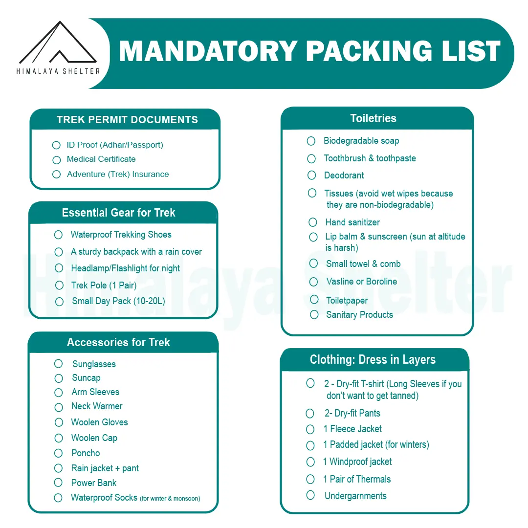
Mandatory Backpacking List for Aancha Top Trek
Clothing and Backpack
Get a good backpack (50 L) with a rain cover. Look for a bag that can provide you good back support. Pack 4 quick-dry t-shirts and 2 trekking pants. Get a pair of thermals (upper and lower) for night. Pack a fleece jacket or woolen sweater as a mid-layer. Get a waterproof wind breaker for sudden rain and chilly winds. For winter trekking, get a good down jacket. Now pack a woolen beanie and a balaclava. Get two pairs of gloves (woolen and waterproof). You should also pack a suncap for the daytime.
Footwear
You should look for good quality trekking shoes. Your shoes must be waterproof and provide good ankle support. Do not wear a new pair of shoes on the trek. Your feet must be familiar with the shoes. Now pack 4 pairs of trekking socks and 2 pairs of woolen socks. Pack a pair of comfortable slippers or sandals for the campsite.
Personal Care
For personal care items, start packing with your toiletries. Get a small zipper pouch and pack all the toiletries. Now look for a quick-dry towel and a toilet roll. You should also pack hand sanitizer and moisturizer. Pack a sunscreen that can protect your face from sunburn. You can also pack some snacks for the trek.
Maximize the Parang La Trek Experience with a Good Physical Fitness
Physical Fitness Preparation for Trek:
To overcome the difficulty level of trekking, it requires strong cardiovascular endurance, muscular strength, and overall physical fitness. Incorporate these exercises into your routine to increase strength, stability, and stamina, which will help you tackle difficult terrain sections of the trail at high altitudes.
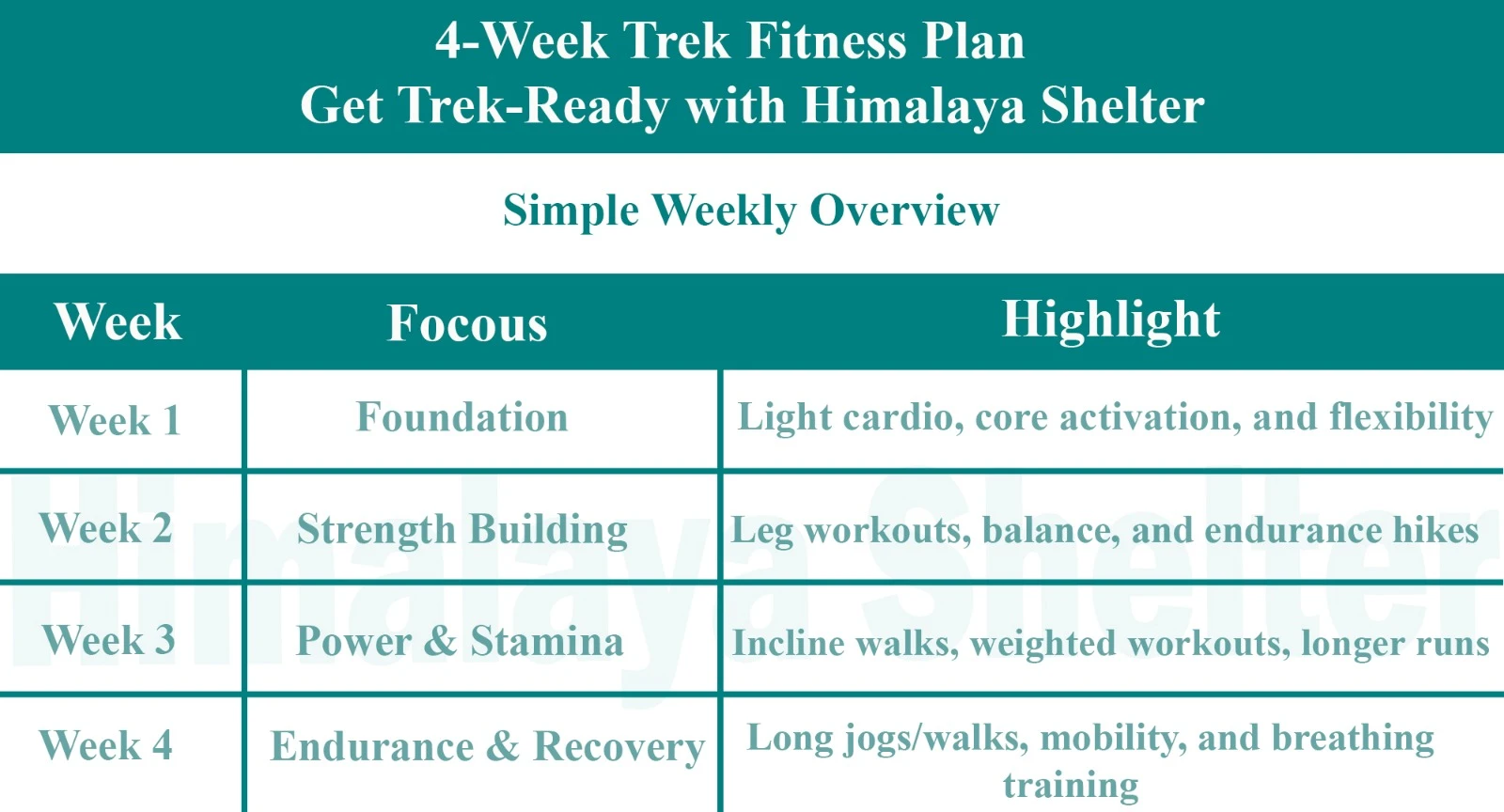
Overview

Foundation
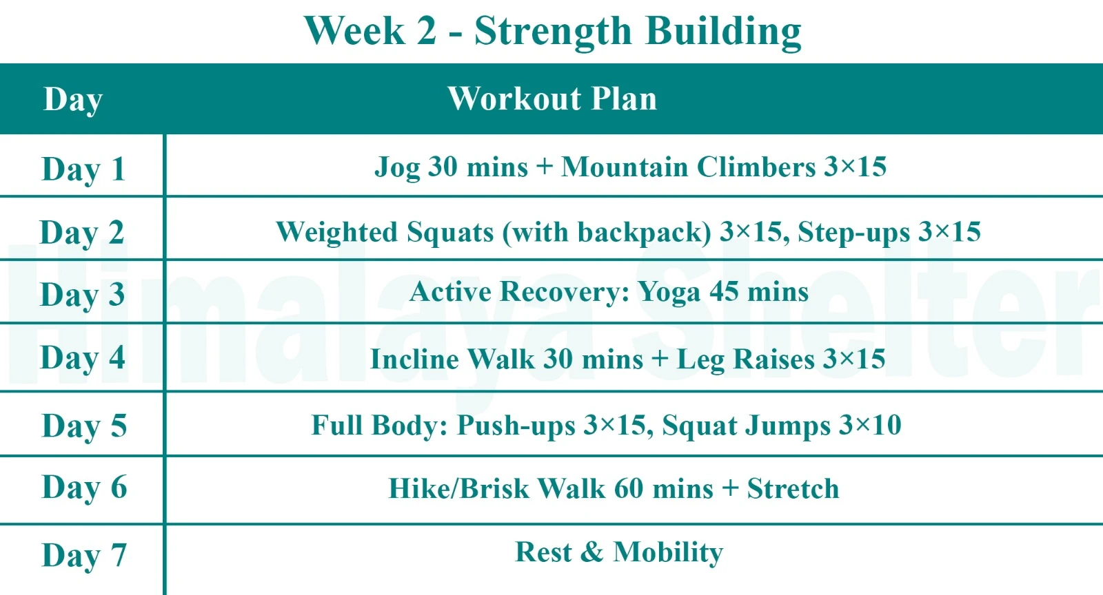
Strength Building

Power & Stamina
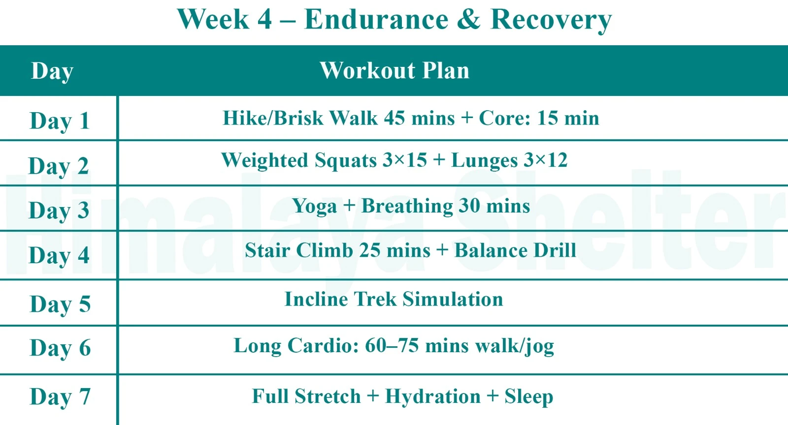
Endurance & Recovery
Inclusions & Exclusions
Our treks are specially designed by the experienced team at Himalaya Shelter, taking you on an adventure of a lifetime all while making you connect not only with the bountiful nature but also with yourself and with others on the trek with you creating wonderful memories which will last you a lifetime. All Himalaya Shelter treks are guided by experienced Trekkers having vast knowledge and experience of the region, providing with insightful information and stories pertaining to the region’s flora and fauna and the history of the region whilst the trek. It is safe to say that on successfully completing the trek, one will gain tremendous insight and experience along with lifetime memories.
Parang La Trek Inclusions
Transport Support
From Day 1 to Last Day
Accommodation
At Base Camp, stay at a local homestay or guest house for one night each, which will give you an insight into the authentic lifestyle of the locals.( INR 5000 per person extra for single sharing throughout the trek )
On Trek stay in a 2-person Vango Halo Pro/A-Shape tent, which is to be shared by two trekkers, built to withstand extreme weather conditions and at the same time making you comfortable after a hard day’s trek.
Camping Equipment
Specially designed sleeping bags that can withstand harsh weather conditions, foam mattresses. Other safety gear like microspikes, gaiters, an ice axe, and helmets will be provided.
Medical Kit
Our team will be equipped with an extensive medical kit, which our team is trained and experienced to use. Oxygen cylinders are used after they are thoroughly inspected throughout the Trek. Even campsites have large oxygen cylinders as backups.
Permission
Forest entry charges for Indian nationals (Additional charges will be applicable for international tourists)
Meals
Breakfast, packed lunch (on trek days), evening snacks, and dinner will be served. A hearty, delicious, and nutrition-filled Veg meals with egg preparation will be provided throughout the trek. (Jain and Vegan Food can also be arranged on prior notification.)There will be a dedicated Kitchen Tent along with a dining tent, which will have a dining table too.
Our Team
A highly experienced and AMC-certified Trek Leader who will help ensure that the entire trek goes smoothly and safely while navigating the challenging conditions during the trek, and is skilled enough to navigate any medical emergency that can arise during the trek.
Local and route Guides who are well-versed with the region and provide an in-depth insight into the local customs and knowledge of the flora and fauna endemic to the region. A dedicated Kitchen staff, which includes a Cook, a helper, and other support staff. There will also be porters and mules to carry common equipment.
Cloakroom
We have a cloakroom facility available for extra luggage. Every trekker is permitted to leave their luggage behind at no charge.
Parang La Trek Exclusions
Personal expenses
Like tips, personal medicines, phone calls etc.
Travel Expenses
Travel expenses from your hometown to the mentioned Pick-Up Point are not included in the trek fee.
From the scheduled pick-up spot to the base camp, we have our own fleet of vehicles like Bolero, Innova, Dezire, or Tempo Traveler (12-seater). This is be shared by trekkers for a pre-decided amount. All vehicles are non-AC.
Personal Equipment
Any personal gear like jackets, shoes, cutlery, or backpacks are not included in the trek fee. We recommend renting them from our Rental Store for an affordable fee. This can be pre-arranged to avoid last-minute hang-ups.
Offloading
We encourage carrying your backpack to get into the true spirit of trekking. However, if needed, you can opt to offload your personal luggage of up to 12 kgs for an additional cost of INR 800 per bag per day.
Trek Insurance
A mandatory trek insurance fee is charged in addition to your trek fee. Since most medical insurance doesn’t cover adventure activities, trek insurance offers essential coverage, enhancing your safety without a significant financial burden.
Buffer day on the trek
We have kept a buffer day on the trek to account for any weather-related delay. If this is utilized, you will need to pay an extra amount to your trek leader.
Anything apart from inclusions
Please carry a lunch box for a packed lunch/breakfast to avoid using polythene and Aluminium foil.
Keeping the Himalayas clean is our own responsibility. Reduce the use of Plastic when you are in the abode of the Sacred Himalaya.
Videos
!
Exceting Videos coming Soon
We’re currently working on putting together all the details for this trek 🎥 Stay tuned, exciting videos covering everything you need to know will be coming your way very soon!
More treks like Parang La Trek
Customer Reviews

Munna Agarwal
5.0
Four of us from the US—all in our 60s and late 60s—took a tailor-made trip organized by Saloni Rathore at Himalaya Shelter, primarily to trek to the Valley of Flowers. We also included short visits to Badrinath and Mana Village, and our guide was Laxmi Jha. I am writing this review on behalf of our entire group. From the very start of planning, our itinerary kept changing, but Saloni showed so much patience and happily kept working with me. In fact, I felt embarrassed to ask for changes so often. However, she never exhibited even the slightest degree of frustration. I truly admire her and am so grateful for her help. As for our guide, Laxmi—what can I say? She is phenomenal! She is a deeply caring person who took every measure to ensure our safety and well-being at each step of the trip. On top of that, during our informal conversations, we learned that she holds numerous accolades in mountaineering, which left us completely astonished. Not to mention, our driver was also wonderfully kind and helpful throughout the whole journey. Overall, I rate this trip with Saloni and Laxmi 5 stars (10/10)! Plan to take many more with Himalaya Shelter.


Olivier Gachelin
5.0
Nous avons fait le trek du Pin Parvati pass avec Himalaya Shelter. Ça a été une grande expérience qui va nous laisser des souvenirs mémorables. L'organisation a été parfaite, toute l'équipe a été extrêmement avenante. Tout a été mis en œuvre pour que nous randonnions en sécurité sur ce trek parfois difficile. Merci Himalaya Shelter. Je recommande !

Rachana Saggar
5.0
A heartfelt thank you to Himalaya Shelter for making my very first trek such a memorable experience! From the very beginning, the entire trip was exceptionally well planned and organized. Every detail was taken care of, making the journey smooth and enjoyable. A special thanks to Bhagwaan Bhaiya, our driver, for ensuring a safe and comfortable journey throughout in a well-maintained vehicle. His calm and careful driving gave us complete peace of mind. And a huge shout-out to our trek leader, Manav—the real GOAT! He was always there whenever we needed help or encouragement. During the challenging Hemkund Sahib trek, he constantly motivated and supported me, especially when I doubted myself. Thanks to his encouragement, I was able to complete the trek on my own, and I’ll always be grateful for that. If you’re looking for a professional, well-organized, and supportive trekking experience, I highly recommend Himalaya Shelter. Looking forward to many more adventures with your team!

Shreyas Pawar
5.0
The Pin Bhabha Pass Trek in July 2025 was a Beautiful Experience. It was very well organised by the team and the trek leaders Adarsh, Tripan, Jassu and the Kitchen team who made the yummiest food for us in these temperatures. Starting from the base camp, the Stay at the base camp Kafnu was warm and comforting with amazing view of the river. As we started the trek day with tasty breakfast, the weather got better and we completed the day 1 at Mulling. All the Campsites were beautiful, especially the one at Phutsirang. The trek leaders were very supportive on the Summit day when the trekkers needed it the most. We safely summited the Pass and entered into the beautiful Spiti valley with vast landscape and later visited the serene Chandratal lake. All thanks to the team at Himalaya Shelter. Cheers!

Sreehari Narikkattiri
5.0
What a surreal experience it was! The Pin Bhaba Pass trek! Never before kind of an experience for me. I’m happy that I did it with the best team who lead the trek, The Himalaya Shelter. Bachan Rana and team was so good. Took care of us well! Definitely doing more with them! ❤️🤗

Tamoghna Das
5.0
Brilliant. Miyar valley was simply awesome and the overall experience was superb 👌🏻 !

Kirti Subhedar
5.0
I recently completed the Valley of Flowers and Hemkund Sahib trek with Himalaya Shelter, and it was truly an amazing experience. Every aspect of the trek was exceptionally well organized—from the accommodation and food to the transportation. Our journey to Govindghat was in a well-maintained Innova, which made the long and challenging drive very comfortable. Our trek leader, Manav, was incredibly supportive throughout the trip. He made sure we took adequate breaks, stayed motivated, and never felt overwhelmed during the otherwise tiring journey. Both of our accommodations in Joshimath and the campsite at Ghangharia were wonderful, offering breathtaking views of the majestic mountains. The staff at both locations were warm, courteous, and always willing to go above and beyond to make our stay comfortable. Having access to hot water and such delicious food in these remote locations felt like a luxury, so a huge appreciation to the entire team for their efforts. Last but certainly not least, a big thank you to Manav for his constant encouragement, dedication, and leadership, which made the trek smooth and enjoyable from start to finish. I would highly recommend Himalaya Shelter to anyone planning a trek. Their excellent service, attention to detail, and genuine hospitality made this an unforgettable experience.

Atharva Ashtekar
5.0
It was so nice experience with Himalayan shelters . The staff was also vey good all the arrangements were done in well mannered.


Ranjana Singh
5.0
Tungnaath , chandrashila and Deoriataal was a good experience .Thanks to Rana and Tanisha for taking good care of us .Looking forward for new adventures with you guys in future .😊🙏

Krishnan Subrahmanyam
5.0
I completed the Gaumukh Tapovan trek solo in May 2026 with Himalayan Shelter, and I cannot recommend Bachan Rana and Bijay highly enough — they were exceptional on every level that matters for a trek of this seriousness. Somewhere on the ascent, when I was clearly struggling, Bachan Rana said to me with a quiet smile: “If you are not running out of breath and getting tired and feeling cold…then you are not in Himalayas.” That line reframed everything. It didn’t minimise the difficulty — it contextualised it. That is the kind of guiding these two bring: grounded, experienced, and deeply at home in the mountains. I came in with two physical constraints: lower back pain and a diabetic-friendly diet. Both were handled with zero fuss. Bachan and Bijay adjusted our pace and added breaks proactively — never waiting for me to ask — and gave hands-on support on steep sections when my back was under strain. They kept my spirits up through the tough stretches with steady encouragement, not hollow cheerleading. On the nutrition side, they paid close attention to what I could and couldn’t eat at altitude, which made a real difference in how I felt across the days. The glacier crossing to Tapovan was the defining test of the trek. This is not a section where you want to figure things out as you go. Bachan and Bijay chose the safest route and timed the crossing well, coached my footing step by step on the ice, and stayed calm throughout in a way that kept my own confidence steady. I felt I was in genuinely expert hands, not just accompanied. Their local knowledge and storytelling added real texture to the landscape and the spiritual significance of the route. For a solo trekker at a place like Gaumukh — where there is no mobile connectivity and the terrain demands respect — having guides of this calibre is not optional. It is the difference between a safe, meaningful journey and a risky one. If you are planning Gaumukh Tapovan, ask for Bachan Rana and Bijay. They are the real thing.

Deepika Garg
5.0
We booked binog tibba trek with Himalayan shelter . It was a very smooth process from booking to experiencing the trek . Our trek coordinator mr. Manish was just awesome .

tanush choudhary
5.0
My experience with himalayanshelter was great. We were the first batch of 2026 to complete the Bali Pass trek. Since the rest of the group cancelled due to the weather, there were only two of us, but the team still provided all the facilities as promised. Our trek leaders, Sonu Bhai and Suraj Bhai, were amazing. They guided us throughout the trail and shared a lot of knowledge about the mountains, trails, and wildlife, which made the experience even better. This was my second trek with himalayanshelter, and I’ll definitely be coming back to them for my next adventure.

Rahul jani
5.0
⭐⭐⭐⭐⭐ Just completed the unforgettable Fulara Ridge Trek with Himalaya Shelter, and it was truly one of the best trekking experiences of my life! The entire team of Himalaya Shelter is extremely professional, talented, cooperative, and always ready to help at any moment. Their dedication towards trekkers’ safety, comfort, and happiness is simply outstanding. Even during very heavy rain conditions, the team worked tirelessly and prepared hot, delicious food for all of us with great care and positivity. Their hospitality and commitment were truly heart-touching. A very special appreciation for our trek leader PK Sir — his work was absolutely excellent! He is highly experienced, multi-talented, energetic, motivating, and always supportive throughout the trek. His guidance, leadership, and caring nature made the entire journey safe, enjoyable, and memorable. The whole support staff and guide team deserve huge respect for their hard work and teamwork. Every member of the team was smiling, encouraging, and ready to support us anytime. Thank you, Himalaya Shelter, for giving us such an amazing and lifetime memorable experience at Fulara Ridge. Highly recommended for anyone who loves trekking and adventure! Looking forward to many more adventures with Himalaya Shelter again. ❤️🏔️

Krishnaraj Jhala
5.0
A very personalised service beyond our expectations. Track lead PK, cook Jagdish, Rocky Rana at the base camp and Rinku were always ready to do anything that we wanted.Jagdish is an excellent cook always with a smile on his face. Hope you will keep serving with same passion and personal touch.


Jayant Bahulekar
5.0
We went to Dayarabugyal trek. Arrangement during trek was nice, it was 4 people kind of solo trek arrangement made for us. The Cook Jaggu was amazing, we never felt away from home. Trek guide Tanisha was also helpful. Thanks!

Sunshriya Tomar
5.0
I had a wonderful experience on har ki dun trek , i would highly recommend all my friends to go on a trek with himalaya shelter only The guide we had during the trek was suraj, he is a wonderful, helpful and knowledgeable guide . Also the guy prakhar with the himalaya shelter team was very nice and friendly with us , he made sure that every wonderful moment was captured Also other team members of this company were very cheerful and helpful in nature At last , for me it was a life long remembering moment

Dhruv Rajdev
5.0
One of the best trek of my life The guide was the best (suraj) he made sure everyone’s safety and the food was the best i ever had on trek and the camera guy was so nice (prakhar) he made sure that no moment was missed Thanks you Himalayan shelter and team for making my trip one of the best trip of my life

rahul mishra
5.0
Excellent experience. We did Bali pass trek with them. were first group to summit after heavy snow in which many group returned. They cattered to our small group of 3. Second trek with them. Highly recommend.

Shalin Thacker
5.0
great experience with Himalayan shelters during our recent visit to Bali Pass Trek. Great support from Suraj and Mukesh throughout our journey.

Vaibhav Pareek
5.0
We successfully completed Bali Pass Trek through Himalaya Shelter. A big Thank You to Mukesh and Suraj for ensuring highest levels of safety and comfort throughout the journey. Both of them are certified mountaineers. The fresh food prepared by Bablu Mama felt like a blessing throughout the journey, as we crossed the 16200 feet pass. This trekking organization is meticulously managed and operated by the down to earth entrepreneur Bachan Rana from Osla. The entire team shows great commitment towards the wellbeing of their guests. I strongly recommend Himalaya Shelter for any High Altitude trek or expedition.

Pranav Yaguvakota
5.0
It was an amazing experience, the trek was very well planned, we had an amazing crew to keep watch, of us our guide sonu negi was very experienced on high altitude and technical treks, this being our first high altitude trek it was quite an experience staying in tents which were set up before we got there, really delicious food made by our cook sanjay gave us freshly made hot food. And a helper along with us named vivek who was a local. The trek difficulty was moderate, on the surya top we got an amazing view of the gangotri and yamunotri ranges. The locations of the tents were very strategically well set up by the advice of sonu. He made sure we were all hydrated and well kept , All in all we thank himalayan shelters for making our experience very comfortable.

Anjali Yadav
5.0
I had an amazing experience on the har ki dun trek with himalayashelter. The whole team was very helpful, guides were caring and supportive, good homemade food , warm local hospitality . It was a very homely environment and i loved every bit of it

Ashank Gawade
5.0
Outstanding Customised Surya Top Trek with Himalaya Shelter – Premium Gear, Elite Guides & Exceptional Food! We recently completed the stunning Surya Top Trek organized by Himalaya Shelter, and they completely exceeded my expectations. If anyone wants a tailored and personalised, safe and premium trekking experience to this 12,900-foot peak, this company is as good as it gets. Perfectly Customised Itinerary. From the initial planning stages, the team at Himalaya Shelter was incredibly supportive, adapting the itinerary seamlessly to our group’s specific preferences and pace. They focus on personalized experiences rather than massive, overcrowded commercial batches, allowing us to enjoy the beautiful forests and meadows of the Garhwal region fully. The guide with our team, Sonu Negi, was absolutely phenomenal. He has completed advanced training from the prestigious Himalayan Mountaineering Institute (HMI), and his deep technical knowledge and sharp safety instincts kept us feeling entirely secure. He wasn't just a leader; his encouraging nature, deep familiarity with the terrain, and mountain views (like Mt. Bandarpoonch and the Gangotri range) made the journey unforgettable. Most importantly, he prioritized our safety by proactively carrying portable oxygen and other critical emergency equipment. Since our group of 7 members was ranging from the age of 9 to 73 , this gave our entire group immense peace of mind. The food was an experience in itself. The Backcountry Food by Sanjay our cook, was too good. Massive shoutout to him, who turned our high-altitude campsites into a gourmet kitchen. Every single day, he served up incredibly delicious, fresh, and hot meals that were perfectly planned for the physical demands of a moderate trek. The hygiene standards really good , and having such thoughtful, comforting food waiting for us after a long day of trekking was a total game-changer. Just to show how exceptional the culinary experience was: for fun, Sanjay even prepared fresh puris for Pani Puri right there in the middle of the mountains, and we wrapped up our evenings with warm, delicious Gulab Jamuns as desserts! Treating us to these kinds of treats at high altitude was a level of hospitality we never expected. Talking about the Camping Gear. The quality of the camping equipment provided by Himalaya Shelter is drastically superior to what other mainstream trekking companies offer which I have experienced in my earlier treks. Heavy-duty, clean, double-layered tents that provided excellent insulation and kept us dry against the unpredictable mountain weather. Thick mats and high-quality, cold-rated sleeping bags with fleece inner for the feet that made sleeping in chilly high-altitude conditions genuinely comfortable. Every zipper, tent pole, and piece of technical gear felt in very good condition and maintained very well. Himalaya Shelter perfectly balances top-tier safety, impeccable local hospitality, and premium comfort. I am immensely grateful to Sonu, Sanjay, and the rest of the crew for an unforgettable adventure. I will absolutely be booking my next Himalayan trek with them.

Manish Garg
5.0
27th May 2026.. date saved as Bali Pass Summit with HIMALAYA SHELTER. It was our 04th trek with Himalaya Shelter & as experienced earlier, everything was just superb viz camps, foods, trek management, guide.. SONU (the Trek Leader/Guide), with his experience & acumen, made the trek even more enjoyable & doable. He pushed & motivated us all throughout the trek. Overall an excellent experience with Himalaya Shelter team. Will suggest everyone to go with Himalaya Shelter and see it themselves. All thanks to HIMALAYA SHELTER.

Prasanna Kumar
5.0
We had an Amazing Experience with Himalaya Shelter The Surya Top Trek!! This was our first ever trek to the Himalayas with Himalaya shelter. we recently completed The Surya Top Trek which was a moderate trek and we all managed to finish the trek!! It was truly an unforgettable experience. The trek offered stunning mountain views, peaceful forests, beautiful campsites, and a magical view of the Gangotri And the Yamunotri ranges from the Surya Top. A special thanks to our guide, Sonu Negi, who was experienced, friendly, and extremely supportive throughout the journey. Since this was our first high-altitude trek with 3 nights of wilderness camping, his planning, guidance, and focus on safety made us feel comfortable and confident at every step. Our food was cooked by an marvellous cook Sanju who cooked amazing food throughout our trek and even in our campsites…!! The campsite arrangements, and overall management were excellent. The entire team treated us like family and made the trek even more memorable. Highly recommend Himalaya Shelter for anyone looking for a safe, well-organized, and memorable Himalayan trekking experience!!

Daksh Sundriyal
5.0
For those who want to experience an adventure of a lifetime 💯 recommended. Sonu bhai the coolest guide

Hema Sri
5.0
Bhuran Ghati Trek – Himachal Pradesh Just returned from an amazing trek to Bhuran Ghati with Himalaya Shelter — absolutely loved the experience! Their small group format ensures personal attention to every trekker, making it a safe and comfortable experience for solo travellers and groups alike. Trek lead Bachan Rana was excellent — clear with guidelines and always made sure everyone was safe. Freshly cooked meals on the trail, a luggage offloading option for those who need it, and rental trekking equipment make this one of the most hassle-free treks you can book. Having a female trek lead, Tanisha, is a wonderful touch that makes women and solo female travellers feel much more at ease. Highly recommended for anyone looking for a well-organised, safe, and memorable Himalayan trek! 🏔️

tuhina sen
5.0
Hey we completed B the phulara ridge trek and safely reached Dehradun today. We enjoyed the trek throughout. The trails, the forest, the ridge walk was thrilling. I would like to extend my heartfelt appreciation for the trek guide Sooraj and the support staff, cook for arranging the trek and supporting us throughout . Sooraj was polite and patient always especially with my son who is 8 and was doing his first trek. He kept entertaining us with all information about different flora and fauna while walking through the forest trails. The cook served tasty meals always and we loved eating local vegetables plucked from the forest. Overall we had a wonderful experience. Thank you .

Haritha N R
5.0
The team was soo good. Food and service also absolutely fine. And it's very safe for girls even if they are in a solo trip

ajit yadav
5.0
One of the best and trusted team to go with , Manisha and Tripian ranna have nothing but supportive and kind towards us , they were ready to help us in every moment. It's amazing how this company create environment of fun and adventure. Doing all my treks with them in future.

satish gondhalekar
5.0
Himalayan shelter is a local sankri based Adventure tourism company. They have deep knowledge of region, staff is professional and helping, indeed it was a great trek Thanks All

Shubhadeep Ghosh
5.0
Over the phone call / whatsapp, the plan was very detailed. The Trekking charges were clearly spelt out and it sounded quite reasonable. From Dehradoon Hotel, the pick up was very smooth and right on time. The driver stopped at very convenient places for breakfast/lunch and other breaks. The base camp was in a beautiful location. The food available there was basic and very tasty. The rooms were very cosy and view from the rooms were very good. Our trek guide, Mukesh, met us in the basecamp and briefed about the trek plan. He was very welcoming and helpful. During the entire trek, Mukesh was with us. We had an excellent experience with him. He was very accommodative and helpful. There were few places where I was slipping where he came to help me out promptly. He ensured that we are not stepping in wrong places through out the trek. It was extremely cold and rainy the time we arrived in Osla. He sensed our struggle in acclimatisation with the harsh winter condition. Mukesh was very prompt in giving us the food to the room. In the camp site as well, during the very cold condition, Mukesh delivered snacks/tea/hot water etc to the camp so that we didnt had to come out to face the wrath of cold condition. Overall I and my son, had a very good experience with Himalaya Shelter's Har Ki Dun Trek and with Mukesh especially. I will definately go with them next time for another adventure.

Kritika Patidar
5.0
Thank you Himalaya Shelter for making this one of my best experiences so far. The staff were supportive and very helpful in everything. The stays and food were awesome, we also got to explore a little bit of the local culture. Already looking forward to planning the next trek!

Neha Khare
5.0
We recently completed the Ranthan Kharak Trek with Himalayan Shelter in mid-April 2026, and it was an amazing experience. The trek is बेहद scenic with beautiful meadows and stunning sunrise & sunset views. A big thanks to Bachanji, Tanisha & on-field Team for their constant support and guidance—they made the journey smooth and enjoyable. The warm soups and delicious meals were a big comfort after long trekking days. Truly a lifetime memory. Highly recommend Himalayan Shelter for a well-organized and memorable trek!

Gayatri A
5.0
We recently did Ranthan Kharak trek with Himalayan Shelter, it was a great experience. Mr. Bacchan, Tanisha and their entire team took very good care of us. Accommodations and food was top notch. Mr Bacchan's took appropriate decisions depending on weather conditions which helped us achieve our summit. Thank you Himalayan Shelter team.

Latha Ravichander
5.0
Latha Ravichander Mumbai i have attempted my 1st Himalaya trekking. It was very nice scenic and also is was managed by excellent trek leader, Thoy & Suraj who have helped us in all the scenic places and helped us in the tough climbs. The cook & the Subhashji who take care of the horses and our luggage too for the whole trek were awesome. The early morning lemon tea, breakfast, lunch, evening snacks & dinner was very nice and yummy. One suggestion if their is senior citizen dont keep a tough route or new route in the trek. The Boslo to devsu tht jungle route was very risky & last climb was also tough. Himalaya Shelter hip hip hurray

Ashwini Khodre
5.0
Just finished the Har Ki Dun trek with Himalaya Shelter and it was unreal. Huge thanks to our guide, Surender, who really knows these mountains and kept us motivated the whole way. Also, a massive shoutout to Vijay Singh Chauhan—the food he cooked at those altitudes was easily the highlight of our nights. Best team ever!

shanti dasari
5.0
Himalaya Shelter made my Har Ki Dun trek unforgettable. A huge thanks to the Director, Bacchan Rana, who truly delivered everything he promised during booking. What made it special: Amazing Guides: Big shoutout to trek leaders Suraj and Thoiba. They are experts, super supportive, and kept us motivated. Homely Vibes: The "ghar jaisa" care was real. We felt so well looked after. Food & Stay: The food was delicious and the stay was the best we could ask for. ⭐ 5/5 Stars Bottom line: Trustworthy team and excellent service. Highly recommended!

Shilpa Kishore
5.0
Went with Himalayan Shelter to the Aancha top trek. Amazing hike, beautiful scenery and best of all, a while lot of pure white snow at the peak in the month of April! The HS team was incredible, with Nitin Bhai as the iconic guide and Micheal Bhai and Rocky Bhai being the best cooks and assistants possible. Micheal Bhai made slides on the snow on the way down, making it extremely fun to get down. Recovery from trek everyday was so instant with amazing evening snacks and chai.The team also helped make blazing campfires, making our trip as memorable possible.

Sangeeth Aloysius
5.0
We had a great time with Himalyan Shelter doing Ranthan Kharak trek. We were 10 of us, including 4 kids with youngest one aged 8… This was our third private trek in the Himalayas, and the trek with Mr Bachan and his team was undoubtedly the best. He was really flexible right from planning and ensured that he took the best calls every day to maximise both the experience and convenience. Food was absolutely the best.. Team served us local cuisines, Samosas, Rasagullas etc… We were pleasantly surprised by the yummy food we were served during the trek… Mr Bachan had great foresight about the weather and physical conditions of the entire group and ensured that he customised the plan daily for us. He would also distribute the team responsibilities in such a way that everyone can walk at their own pace without making them feel any less accomplished or supported. Would recommend Himalayan Shelter and plan to use their service again!

Pranav Patel
5.0
I had a wonderful experience during my trek to Kedarkantha last week through Himalaya Shelter. We had unseasonal snow and rainfall, however the trek was completed successfully along with Tirpan Rana who accompanied me from Himalaya Shelter. All the arrangements throughout my journey were excellent. I look forward to my next trek with Himalaya Shelter.

SUBHAJIT SAHA
5.0
I must say he is one of the best trek guide in term’s of behaviour and personality .. If you planing for go to a trekking please choose him without any hasitation ..

prasanna patgaonkar
5.0
Went for ranthan kharak april 2026 Wonderful experience, excellent food excellent arrangement specially Bachan Rana and Tanisha arranged everything perfectly .. We also had 4 kids .. they took very good care of them. The trek was conducted beautifully and we were able to walk at our own pace and maximise time with nature. Thank you team Himalayan shelter

Pim van Doren
5.0
Had a great experience! Sonu immediately made me feel at home, helping me with planning out the Har Ki Dun trek, and helping with climatizing. Mukesh was a great guide during the trek, providing everything I wanted. Also, great food at the shelter and during the hikes, props to the chefs!

Pavan Kanumalla
5.0
Amazing experience and hospitality. The full staff was so helpful and accommodating. Thoiba was an excellent guide. Highly recommend!

Chhavi Solanki
5.0
Himalaya Shelter ke saath mera trekking experience bohot hi kamaal ka raha! Shuruwaat se lekar ant tak, sab kuch bohot well-organized tha. Guide bohot supportive aur knowledgeable thhe, jiski wajah se mushkil raaste bhi aasaan lage. Khana lajawab tha aur safety ka poora dhyan rakha gaya. Agar aap ek adventurous aur hassle-free trek dhoond rahe hain, toh Himalaya Shelter is definitely the best choice. Highly recommended.👍🏻🏔️

Radka Sporre
5.0
I had an incredible solo experience on the Kedarkantha Trek with Himalayan Shelter—truly a once-in-a-lifetime journey. It was just me and the guide/team, and everything was well organized and thoughtfully handled from start to finish. A special thank you to my guide, Thoiba, who was attentive, kind, and very accommodating throughout the trek. He made me feel safe and supported every step of the way. The crew did an amazing job—the food was delicious, and reaching the summit was absolutely breathtaking. An experience I’ll never forget. I’m so grateful and would highly recommend Himalayan Shelter to anyone looking for a memorable adventure.

Pranjal Chaudhary
5.0
I've been trekking since 2020 and been on multiple treks like triund., nag tibba., chandrashila., kheerganga., kareri lake., VOF., hemkund sahib and many more but it's my first trek with himalaya shelter and I must say that it's been the most amazing experience till now. The services they gave and the hospitality and concern they showed us is really heartwarming. Our trek leaders Mukesh Bhai and Suraj bhai are the most caring and providing trek leaders I ever met on any of my treks as those are the guys u can look upto for anything. U can just get a booking with himalaya shelter and leave the rest assured to them and they will surely deliver more than u think and expect. It's been an excellent journey and I'm going to continue it with you guys for a good long period. दोबारा मिलेंगे किसी मोड़ पे., जो बाकी है वो बात होगी कभी.... 🙂🙂

Manisha Sirari
5.0
I recently completed the Har Ki Dun Trek with Himalaya Shelter, and honestly. From the very beginning, their team was super supportive, well-organized, and genuinely caring. Our trek leader Sonu was knowledgeable and made sure everyone felt safe and comfortable throughout the journey. Meals and accomodations were excellent. Big high-five to Himalaya Shelter Guest House in Sankri. I would highly recommend Himalaya Shelter to anyone planning Har Ki Dun or any other Himalayan treks. Whether you’re a beginner or an experienced trekker, they make the whole experience memorable, safe, and truly enjoyable. Planning my next trek to Buran Ghati again with Himalaya Shelter. Kudos

mayur jain
5.0
Very nice services, very accommodating, and polite behaviour of everyone from central helpline to the workforce on ground - guide, cook, drivers. Will definitely book Himalayan shelters for all my trekking plans in future, and will recommend others too.

Siddharth Sivaramakrishnan
5.0
I went on the Nagtibba trek with my 7 year old son. This was my 5th trek with Himalaya Shelter but first with my son. It was his first ever trek and he absolutely loved the experience. The arrangements were perfect with attention to small details like arranging a blanket and mattress for my son who would not have snugged into a sleeping bag. They had also arranged head torches for everyone. The food is always a highlight with simple yet delicious meals especially after a day long trek. The guides are knowledgeable and make sure it’s an experience to cherish.

Amy C
5.0
himalaya shelter review I went on the Har Ki Dun trek with Himalaya shelter in mid March. Throughout the planning of the trip they answered every question we had and were able to adjust the trek itinerary to fit our plans. My only criticism is that the weather forecast they sent us was not quite for the right place (I don’t think any exist for the actual right location of this!) so just be aware of this- if you follow their packing guidance you would have all the right stuff anyway! and anything you are missing you were able to hire on arrival in Sankri easily. Throughout the trek our guide Thoiba was excellent and always ensured our safety and comfort throughout as well as chatting to us about the local history and geography. During the trek we had a lot of unexpected snowfall and Thoiba and the rest of the team adjusted our itinerary when needed and always made sure we were as warm as possible delivering lots of warm food and chai to our tent (the food provided throughout the trek by Sanju and Thoiba was excellent and plentiful- they were also able to cater to dietary requirements if needed). All the logistics were handled seamlessly throughout with mules organised to carry all the stuff and all the tents set up normally before we had even arrived at the campsite! Overall I absolutely loved the trek- I highly recommend the Har Ki Dun trek for anyone wanting a few days of adventure with relatively easy hiking combined with some time in some remote Himalayan villages!

Ayushmaan Chakraborty
5.0
I did my first trek with Himalaya Shelter. This company was recommended to me by a friend and they do stand up to it. During our Nag Tibba trek from pickup to drop off at Dehradun they arranged it well ahead of time and in an organized manner. The staff served delicious meals and our Trek Leaders Tanisha and Risabh were professional courteous and sometimes downright funny. I would recommend the Himalaya Shelter to anyone going hiking in Uttarakhand.

Emma Lewis
5.0
Thoroughly enjoyed the Har Ki Dun trek with Himalaya Shelter! The booking process was easy and they kindly answered all our questions. Our guide Thoi Ba dealt with the unexpected snowfall very professionally and the food from our chef Sanjay was always delicious with lots of variety. Couldn’t recommend enough!

Satyam Kumar
5.0
Yeh trek experience bilkul unforgettable raha Har moment nature ke saath connect Staff bahut helpful aur friendly the Har situation mein support milta raha Guide experienced tha aur clear instructions Safety ka pura dhyaan rakha gaya Stay aur food bhi kaafi achha Simple par tasty aur energy dene wala Overall journey smooth aur well managed Definitely recommend karunga sabhi travelers ko

Sanjay Purohit
5.0
We were a group of 5 treking friends ( Nandu / Vikram / Uday / Mukund / Sanjay ) from Maharashtra with age range from 70 to 75 yrs. We have been trekking in Himalayas for more than 30 yrs. with different agencies. This was our 1st experience with Himalaya Shelters and it was very good. Mr Rana ( Himalayan Shelter ) was very coperative to accomodate our requirements. All the team members ( Leader Nitin / Guide Chandramohan / Cook Vjay / Driver cum helper Ravi ) were very helpful, cooperative & courteou

NANDKUMAR BHAGWAT
5.0
Our group consisted of 5 trekkers all senior citizens above 70 years of age. We did Bramhtal Trek on 14th March 2026 to 22nd March 2026 Rishikesh to Rishikesh via Lohajung. Mr. Bachan Rana of Himalayan shelter arranged our customized trek. Trek leader Mr. Nitin Trek Guide Mr. Chandramohan cook Mr. Vijay and driver cum assistant Mr. Ravi. Food camp management and service throughout was excellent. Tents, camp chairs toilet tents sleeping bags and dinning tent were in good condition esp. Camp at tilandi was on snow and we had no difficulty neither any inconvenience. Preparation and choice of food was very good. Entire staff was very punctual through. Selection of Home stay at Rishikesh and Lohajung was good. All in all we all were very happy with Himalayan shelter. Nandkumar Bhagwat

Uday Paranjpe
5.0
We, 5 friends all between 72 to 75 years young did Brahmatal Trek with Himalaya Shelter on 14 to 22 March 2026. Bachan Rana helped a lot to customise our program details. I must mention here that our Trek Leader Nitin was very caring and humble. Special thanks to our cook, Vijay for very tasty and variety preparations. Our local guide, chandramohan from Govid Ghati was very knowledgeable. Our driver, Rabi, was careful. Although the wheather suddenly changed to snowfall and rains, the support team was ready for all eventuality. All in all I can say that Himalaya Shelter and the trek support team made our trek a comfortable, memorable experience.

Hardik Khandelwal
5.0
It was an amazing trip, Pravesh (PK) bhaiya and Santosh bhaiya were very helpful, the food provided was also nice, very helpful whenever we needed help

Katheryn Antonio
5.0
I had an amazing experience. The village (Pantwari) was so cute, Nitin was so helpful and respectful the entire time. My only downside at Nag Tibba was that the dogs didn’t stop barking and the tent I slept in was on a downslope which means I felt like I was slipping all night. Regardless, the views were beautiful. I felt so safe and comfortable. Every driver and person was so warm. The food was delicious too, I do recommend bringing a snack for the summit, hiking poles and warm layers. Also ANTI NAUSEA meds for the windy roads. MUST.

Tridibesh Misra
5.0
Very good management and super friendly people. Driver was very good and experienced. Food from day one till the end was very tasty. Guide (PK bhaiya) was super chill and always motivated us during the trek. Overall wonderful experience.

Ayush Sharma
5.0
Staff(driver + guide + cook) was very friendly and helped a lot throughout the trek. Food was very tasty from day one till last day. Accomodation was good and the equipments including rental gears were of great quality. Enjoyed the trek and will recommend to go with Himalaya Shelter as your travel companion.

Sanjay Sorathiya
5.0
It was excellent experience and fantastic tracker guide of Himalaya shelter team Mr. Sonu best tracker and nice food arrangements and good service

brgajipara
5.0
Completing the Aancha Top Trek with my friends was one of the best experiences I’ve had in the mountains. A big thank you to Himalayan Shelter for organizing such a wonderful trek. The entire team was very professional, friendly, and supportive from start to finish. Our trek leaders and guides were experienced and always motivated us during the journey. The food, campsite arrangements, and overall management were excellent. The highlight of the trek was definitely the stunning view from Aancha Top. Standing there with friends, surrounded by the beautiful Himalayas, was truly unforgettable. I highly recommend Himalayan Shelter to anyone who wants a safe, well-organized, and memorable trekking experience.


Bhavdip Ravani
5.0
Accommodation supper Staff co-operative Food delicious Sherpa helpfull, well knowledged, well trained ⭐⭐⭐⭐⭐

Amish Patani
5.0
Kedarkantha + Har Ki Dun treks with Himalaya Shelter is sheer bliss. Service + Knowledge + taking care of smallest things = Return for more. We loved the entire experience and will be doing all future treks with them. Keep up the good work and spread your wings. India has so much to offer at such good price to unwind...

Pankaj Shukla
5.0
I would like to share my sincere appreciation for Himalayan Shelter for organizing our trek to Kedarkantha. From the very beginning, all arrangements were exceptionally well planned and professionally managed. The coordination, communication, and on-ground execution reflected a high level of experience and commitment. The support staff were courteous, helpful, and always ready to assist, ensuring that every participant felt comfortable and confident throughout the journey. The trek was structured in a disciplined and well-paced manner, which enabled us to achieve the summit safely and successfully. Their focus on planning, safety, and teamwork truly enhanced the overall experience and made the achievement even more meaningful. I had a wonderful experience and would highly recommend Himalayan Shelter to friends and colleagues who are looking for a reliable and professional trekking organization. Thank you for making this journey memorable and rewarding. Pankaj Shukla

Tack gaming
5.0
The trek was fantastic. The guide was really helpful and patient. He took everyone to the summit with great pace. The food and tents were set up before we reached our destination allowing us to rest properly. The food was also made at site which was great as to have hot food at such a place was luxury. The team from Himalayan shelter guided us and made our journey better. If I were to go on another trek I would definitely choose Himalayan Shelter again.

Thibault Dargere
5.0
My experience trekking to Chandrashila with Himalaya Shelter was excellent, especially as a beginner-friendly introduction to the mountains. The team was incredibly experienced and well-prepared, providing two guides and a driver who were all exceptionally kind and professional; a special mention must go to Mukesh, whose expertise made the journey feel seamless. While the guides were fantastic and the route was very welcoming, the itinerary did have a fair amount of downtime each day, and I personally feel the schedule could have been a bit more compact. Overall, it was a great trip led by a staff that truly knows their craft.

SHREYA K 19ABARC047
5.0
We had a good experience with Mr. Tirpan singh as captain. He was very helpful and even the food was very tasty sanju bai and anil made sure we eat proper food at all the times . The whole stafff was very helpful trhough out the trek


Bianca Nuti
5.0
Great experience with Bachan Rana and Mukesh in the trekking through the Kunjapuri temple and Neer waterfalls! We all loved it, they were very kind and careful to make it unforgettable! Thank you guys

Caterina Giannessi
5.0
Veramente un bel tour e trekking a rishikesh. Ci hanno potato con una jeep in vetta a vedere l’alba sui picchi dell’himalaya, poi siamo scesi lungo la montagna per circa 9 km. I ragazzi ci hanno aiutato nella discesa e ci hanno portato e preparato la colazione con roti, uova, patate e The e caffè durante il trekking. Veramente consigliato!

Sudhakar Tetali
5.0
The last two days were hectic in enjoying the treks in and around Rishikesh and Pantwari in Uttarakhand. As a beginner and at 60 years of age, it was tough for me to do these treks but I enjoyed it as a challenge and tested my lungs and heart functioning to the max limit. I travelled this trip solo but met a few very young guys from Delhi/Ghaziabad who were part of the trekking group. These guys were awesome and full of energy. I chose Himalayan Shelter as my tour guide and Bachan Rana was very helpful in arranging everything and he is very experienced in this business and as an accomplished trekker . I believe trekking/hiking gives you soul satisfaction and one of the best ways to make new friends. Overall the Rishikesh trip added a new perspective on how to lead a single life and deal with physical challenges.

Samwise Patterson
5.0
We had an awesome experience with the entire Himalayan Shelter team! Our guides were Bachan rana, and Ramesh sajwan and they both an amazing job taking care of us. They knew the trails very well, they took care of our needs at camp like food and shelter and ensured our safety during the entirety of the journey. If you get the chance, please take this adventure with the Himalayan Shelter team!

Izzy Bernbaum
5.0
Some of the nicest guides and best views you could imagine highly recommend.

Gordon Gogulski
5.0
Best experience ever, very caring and make the best food. Highly recommend.

Paige Alcorn
5.0
absolutely beautiful hike and the guides were amazing, open to answering questions and making the whole trip!!

Reema Kuwar
5.0
I recently trekked to Kedarkantha with Himalayan shelter. I would like to appreciate the whole team, for their cooperation, patience and making the submit a success. Special thanks to Nitin, Sonu and Arjun, to make sure, everyone took part in the trek, and for their genuine help to all the trekkers. The food was fabulous as well. Thanks for your, help and guidance team.

Ankit Kundra
5.0
Himalaya Shelter is an excellent trekking company. The staff was extremely cooperative, and the rooms were clean and hygienic. The food was outstanding — easily 5 stars. Our trek leader, Saurabh, was highly experienced and continuously guided, motivated, and supported us throughout the trek. The Kedarkantha trek itself was an unforgettable, once-in-a-lifetime experience that gave us a bag full of memories and valuable life lessons. If you’re looking for a reliable and well-organized trekking company, Himalaya Shelter is a great choice.


Archish Vasu
5.0
Recently I had an amazing experience on the Kedarkantha Winter Trek with Himalayan Shelter, and a big part of that was thanks to Tanisha Chauhan our trek lead. From the very beginning, she was extremely helpful, professional, and supportive. She guided us clearly with all the trek details, preparations, and logistics, which made the entire journey smooth and stress-free. During the trek, her coordination and constant encouragement really stood out, especially in the challenging winter conditions. Tanisha’s positive attitude, dedication, and care for every trekker made this experience truly memorable. I’m very grateful to her and highly recommend Himalayan Shelter—and especially Tanisha—for anyone planning a Himalayan trek.


Manish Kukreja
5.0
Yes, ~12,000 ft / ~3,600 m! We did it with the exceptional team at Himalaya Shelter. We are a family of four with two boys (11 and 12 years old), and this was our first Himalayan trek at Dayara Bugyal. We were picked up from Dehradun Airport and driven to Uttarkashi, where we stayed for a night. The next day, we drove to Raithal and started our trek to the Gui campsite, spending the night in alpine tents at freezing temperatures of -1°C. On the second day, we walked about 8 hours in total and scaled the highest point of Dayara Bugyal (~12,000 ft). That evening, our cook, Subhash ji, presented us with a surprise cake during dinner to celebrate the moment. The night was even colder at -4°C, and the peaks saw some snowfall. On the third day, we descended to Raithal and drove back to Uttarkashi for the night. On the final day, Bim (Sasi) and the Himalaya Shelter team dropped us off in Rishikesh to continue our adventures in Dev Bhoomi, Uttarakhand. We would like to thank the entire Himalaya Shelter team: Bachan ji and Tushar for booking and operational assistance; Tanisha, our trek leader, for guiding us and being patient and encouraging with our children; Sonu for providing overall guidance, care, and sharing his experience throughout the journey; and Subhash ji for the amazing, thoughtful, and yummy food, as well as accommodating our requests. Finally, not to forget Bim (Sasi)—a safe pair of hands behind the wheel who made the whole trip safe and comfortable. Thank you! We hope to continue this relationship with another adventure—maybe Har Ki Dun?!

Devanand Jethanandani
5.0
It was very wonderful trekking experience of Ancha Trek we had with Himalay Shelter.. Very delicious food we enjoyed on the entire trip and thanks to the cook Bijay Singh Overall experience was memorable one.

Jitendra Teelani
5.0
We completed the Ancha Top trek with Himalayan Shelter, and overall it was a great experience. The arrangements were well managed and the service was amazing. A special mention for the food — it was truly awesome, which made the trek even more enjoyable in such cold conditions. Huge thanks to Vijay (MAMA) for the delicious food and warm hospitality 🙏 — it really felt like home on the mountains. However, we would like to share one concern. We were a group of 8 people, and unfortunately, we felt that the guide Mukesh was mostly involved with one foreigner guest, due to which our group was often left on its own. This affected our overall experience and group coordination. We hope Himalayan Shelter will look into this and ensure equal attention and support to all trekkers in a group. Overall, a memorable trek with great food and service, with scope for improvement in guiding support.

Alpeshbhai Kachhadiya
5.0
GOOD SERVICE COOK IS VERY GOOD "BIJAY SINGH" HIS COOKING IS VERY DELICIOUS HIMALAYA SHELTER GROUP MANAGEMENT IS TOO GOOD WITH CUSTOMER WE FEEL LIKE FAMILY PERSON

Mehul Patel
5.0
Food was so good. Special thanks to Mr. Bijay singh Hospitality and all arrangements also very good Ancha Top trek


Sourabh Unnikrishnan
5.0
Had a fantastic time with the team during my Dodital trek and Aancha top trek. Their warmth, care and expertise gave no room for discomfort at anytime. It was a great get away with friends while seeing each other a little outside our comfort zones. Highly recommended!

Anagha Ghorpadkar
5.0
We had a fantastic trek with Himalayan Shelter in dec 2025. We were a group of 14 people. Right from the time we reached Dehradun and until our drop back to Rishikesh, the entire journey was very well arranged. Timely pick up, comfortable road trip in a TT to Raithal, trek preparations, the lovely Pahadi food, comfortable stay at Raithal was just awesome. Through the trek, Mr Bachan Rana and Mr. Abhimanyu were very enthusiastic and encouraging. Rocky was a hero for us- always with a smile and serving us yumm food. The kids loved him as he gave them super maggi 😊. Anything we asked Rocky said - “ho Jayega” which put all our questions to rest. Our first Himalayan trek and it was made memorable with Himalayan Shelters. They made it comfortable as home in the Himalayas 😊. Looking forward to more adventures with them.

Sanwar mal Yadav
5.0
Had an amazing experience doing the Aancha Top trek with Himalayan Shelter. The team was professional, well-organized, and super supportive throughout the journey. Great stay, tasty food, and breathtaking views! Highly recommended for anyone planning a Himalayan trek.

Vaishali Bathvar
5.0
Amazing place, view and special thanks for the co-operative staff #mr.Nitin#mr.Ramesh our treker they gave us best treking experience and they are too polite persons , and hotel staff they gave best hospitalise #mr.subhas#mr.sooraj raja # mr. goldi Specially recommend this place plz visit and enjoy your trek.😊 Rooms are better also☺️

Ashmita Chatterjee
5.0
I have been travelling with Himalayan Shelter for two years now, and it has been an absolutely wonderful experience. The guides are extremely knowledgeable, talented, and responsible. They were also very generous and supportive throughout the trek, always ready to help and motivate everyone. Thanks to their excellent planning, guidance, and constant encouragement, the trek never felt exhausting at all. Safety, comfort, and group morale were clearly their top priorities. I felt well taken care of at every step.
Gallery
!
Exciting Images coming Soon
We’re currently working on curating the best visuals for this trek. Stay tuned — stunning images will be coming your way very soon!
Read more on Parang La Trek
!
Exceting Blogs/Trek Diaries coming Soon
We’re currently working on bringing together insightful blogs for this trek ✍️ Stay tuned, detailed stories, tips, and everything you need to know will be coming your way very soon!
Parang La Trek FAQs
It may start from the Kardok village in the Leh region or the Chicham or Khibber villages in the Spiti valley. It is an ancient trade route between the Spiti Valley in Himachal and Tibet & Changthang in Ladakh.
The Parang La trek is considered difficult. In this trek, you walk an average of 16 km each day, and the trek goes up to 18,300 ft, which makes it difficult.
The best timing for the Parang La trek is mid-July to September. The weather remains suitable for trekking.
The maximum altitude of the Parang La trek is approximately 5,577 meters (18,300 feet).
The total distance of the Parang La trek is approximately 128 km, which takes you to Ladakh from the Spiti valley of Himachal.
To complete the Parang La trek, it takes 9 to 11 days to complete this trek.
Before the one month of Parang La trek, jog daily for 30 minutes, 15 minutes of running for 15 days of trek, alternate days do squats and lunges for leg strength, practice plank for core strength, do Yoga, and Surya Namaskar for flexibility.
have been doing treks with Himalaya Shelter for the last two years and they are awesome people with pure humbleness.“ Writes Priyesh
- We at Himalaya Shelter consider our trekkers part of our community.
- A family of sorts, and really understand the efforts that you put into taking that much-needed break and setting off to the mountains.
- Some of you may wait for months and even a year to plan out that perfect excursion. That’s why we want it to be “a perfect excursion” for you.
Our testimonials (read below) are a testament to our service-oriented mindset. We take safety into great consideration and ensure our team is trained to handle emergencies. - For a better experience, we provide accommodation on a twin-sharing basis throughout the trek. With most trekking operators, you would get triple or even quad sharing accommodation. Our Accommodation will have attached washrooms.
- Furthermore, we provide the essential safety gear for your trek – Without any additional charges.
- We pamper you with great food, which keeps you going on the trek. (On our Google Maps, out of 300 reviews, over 80 Trekkers mention great food😋).
- We do not outsource services to ensure topmost quality throughout your journey. We use our own fleet of Vehicles to ferry you to the base camp and return.
In the Parang La trek, you will get to see beautiful High Mountain Passes, Spectacular Landscapes, Moriri Lake, Remote Wilderness Wildlife and Birdlife, and Unique Flora.
Yes, you need permission for Parang La Trek. Permission is included in the Himalaya Shelter Parang La trek package.
In Kaza, you will get a network of BSNL and Jio, but Jio is weak there. You will not get after that anywhere, and as you come to Ladakh after the trek there only postpaid will work.
Yes, a 50-year-old person can do the Parang La trek. Anybody above 13 years and below 60 years is eligible, even those above 60 years are also eligible, but they require their proper medical certificate.
To do the Parang La trek, you need to be experienced in trekking because this is high high-altitude trek and the distance is also very long. Beginners can do the Parang La trek if they have excellent fitness, their body is active, or if they train themselves for 2 - 3 months before the trek.
Documents such as Identity card(Aadhar Card)original and few copies, visa and passport for international trekker, passport size photos, medical certificate and adventure insurance.
Yes, a Medical certificate with the signature of a medical officer is mandatory.
Visa, passport, medical certificate and adventure insurance are mandatory for Parang La trek.
Trekking or adventure insurance is needed for high altitudes such as Parang La Trek.
Parang La trek comes in the Inner border line. So inner line permission is mandatory for Parang La trek.
Yes it is possible to do the Parang La trek in 7 days but it is very difficult. Proper acclimatisation is important, continuous height gain without rest can cause problems. So a person with excellent fitness and who is aware of AMS symptoms can do it. But it is advisable to take more days for a better experience. Rush can make it worse.
Yes, but only BSNL networks work at Dumla.
The Parilung Bi river flows in that gorge after Thaltak on the way from Thaltak to Base camp.
Yes, offloading bags are available on Parang La Trek.
Yes, Parang La trek is completely safe with proper acclimatisation.
Available Dates
From
₹140000 $1554
per person