Rupin Pass Trek
TREK DIFFICULTY
Moderate - Difficult
TREK DURATION
8 Days
HIGHEST ALTITUDE
15,280 Feet
GROUP SIZE
12
TREK DISTANCE
63 KM
BASECAMP
Uttarakhand
BEST TIME
May to June | September to October
PICKUP POINT
Dehradun (Prince Chowk)
Rupin Pass Trek, Uttarakhand – A Dramatic High-Altitude Himalayan Crossover
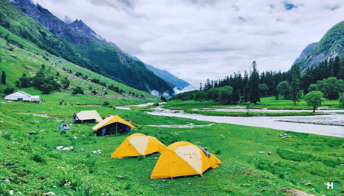
Plenty of people find that the Rupin Pass Trek Uttarakhand offers an exciting adventure with breathtaking views of the Himalayan mountains. This Rupin Pass Trek has been likened to reading a suspenseful book. Every time trekkers turn around, they encounter a new feature, such as a different landscape. Some of the features that trekkers will experience on the Rupin Pass Trek include waterfalls, dense green forests, hanging villages, deep gorges, and wide-open fields and meadows high up in the mountains.
All of these different types of scenery combined create one of the most rewarding high-altitude treks in Uttarakhand, and the Rupin Pass Trek is considered one of the best scenic treks in Uttarakhand.
The Rupin Pass Trek reaches an altitude of approximately 15,250 feet (4,650 meters) and allows trekkers to experience high-altitude terrain of the Himalayas without requiring mountaineering skills or climbing gear. Trekkers can use this Rupin Pass high-altitude trek to continue their transition to more challenging Himalayan trekking routes by developing confidence at higher elevations, while still enjoying a strong sense of achievement without technical expertise.
Even before beginning a hike on the trek, trekkers experience the excitement of discovering new places and people as they start in Dehradun, where the route leads through the lesser-explored Tons Valley in Uttarakhand—far removed from busy cities and deep into remote mountain villages surrounded by forests and river valleys. This marks the true beginning of trekking in Uttarakhand, defined by immersion in raw nature and quiet Himalayan landscapes.
The journey follows age-old mountain paths used by generations, offering insight into traditional Himalayan life. One of the highlights of the Rupin Pass Trek Uttarakhand is Jakha Village, which appears to hang dramatically on a steep hillside. Located near one of the highest inhabited points on the trail, Jakha is among the last permanent settlements before entering the remote alpine wilderness.
After leaving Jakha, the route continues through dense pine and oak forests before opening into vast alpine meadows and high-altitude grasslands. As the terrain changes daily, trekkers encounter new ecosystems throughout the journey, making the Rupin Pass Trek one of the most diverse and representative scenic treks in Uttarakhand and a true showcase of Himalayan trekking.
Camping along the Rupin Pass Trek is a defining experience. Campsites are set in isolated locations far from villages, with no artificial light. On clear nights, trekkers witness brilliant star-filled skies and the Milky Way, creating rare moments of silence and reflection—an experience that has become increasingly uncommon in modern life.
The highlight of the entire trek is the summit day at Rupin Pass, where trekkers climb through snowfields before descending into a completely different valley. This dramatic geographical transition is what places the Rupin Pass Trek among the best treks in Uttarakhand and one of the most memorable high-altitude treks in Uttarakhand.
The combination of adventure, landscape diversity, altitude challenge, and cultural exposure makes the Rupin Pass Trek Uttarakhand an outstanding experience. It is ideal for experienced trekkers seeking an authentic Himalayan journey and remains one of the finest examples of trekking in Uttarakhand.

Rupin pass trek Short itinerary:
Day 1: Dehradun → Dhaula (Drive)
Drive: 200 km | 10 hrs
Route: Dehradun → Mussoorie → Purola → Mori → Netwar → Dhaula
Altitude: 1,580 m
Day 2: Dhaula → Sewa
Trek: 11 km | 6 hrs
Through forests and villages
Altitude: 1,920 m
Day 3: Sewa → Jiskun
Trek: 10 km | 7 hrs
Cross from Uttarakhand to Himachal Pradesh Steep ascent
Altitude: 2,700 m
Day 4: Jiskun → Jakha
Trek: 4 km | 3 hrs
Gradual climb through forest and fields
Altitude: 2,800 m
Day 5: Jakha → Dhanderas Thatch
Trek: 10 km | 6 hrs
Walk along the Rupin River
Altitude: 3,500 m
Day 6: Dhanderas → Upper Waterfall Camp
Trek: 4 km | 2–3 hrs
Short but steep ascent
Altitude: 4,000 m
Day 7: Upper Waterfall → Rupin Pass → Ronti Gad
Trek: 12 km | 10 hrs
Pass Altitude: 4,650 m
Steep ascent and sharp descent
Day 8: Ronti Gad → Sangla → Shimla (Drive)
Trek: 10 km | 5 hrs
Drive to Shimla (230 km/8–9 hrs)
In Himalaya Shelter, we provide you with the option to customize your Rupin pass trek experience. Whether you're an avid mountaineer, an adventure seeker or a group of friends, you can opt for our personalized tailor-made expedition program. This customized program will be exclusively designed for you, taking into account your specific requirements for transportation, accommodation, meals, technical equipment and any other premium facilities you may need during the climb.
Starting from Dehradun (pick up point), the Rupin Pass trek passes through scenic destinations and reaches Dhaula (basecamp). From here, you start your trekking journey.
Himalaya Shelter ensures your journey is safe and memorable with experienced local guides, technical support and all necessary permits. You can even request offbeat routes or sunrise hikes for a more immersive Himalayan experience.
Moreover, no other participants will be added to your group. Choosing a customized program will enable you to enjoy your journey without any hesitation.
Rupin Pass lies between Uttarakhand and Himachal Pradesh in the Indian Himalayas. The name 'Rupin' is believed to be linked with a beautiful girl named 'Roopmati'. As per mythology, it's said that once there was a beautiful and kindhearted girl who lived in the region. She was known for her captivating beauty and charm. Once a king, attracted by her beauty, proposed to her to marry but Roopmati refused to marry him. The king became very angry and being egoistic he forced her to marry him. To escape this, Roopmati ran into the mountains and prayed to god to protect her. For her kind heartedness and purity, god turned into a flowing river- Rupin. It's believed that the Rupin river carries her essence.
During medieval time (750 CE – 1757 CE), the Rupin Pass was used by traders, shepherds and pilgrims. It was used as a traditional route by communities like Bhotiya and Kinnauri for their seasonal movement between the Higher Himalayan region and lower valleys. Due to this, some small settlements on either side of the pass grew around these seasonal routes. The region was crucial in playing the role in the lives of mountain communities.
Slowly and gradually, the surrounding areas of Uttarakhand and Himachal Pradesh started gaining recognition for their natural beauty and passes like Rupin were explored for travel and mapping.
Today, Rupin Pass has become a famous trekking destination. Trekkers come here to experience its changing landscapes- from dense forests to snow-covered ridges and the cultural shifts- from Dhaula in Uttarakhand to Sangla in Himachal Pradesh. Rupin Pass not just connects to two different places but two different cultures and histories also.
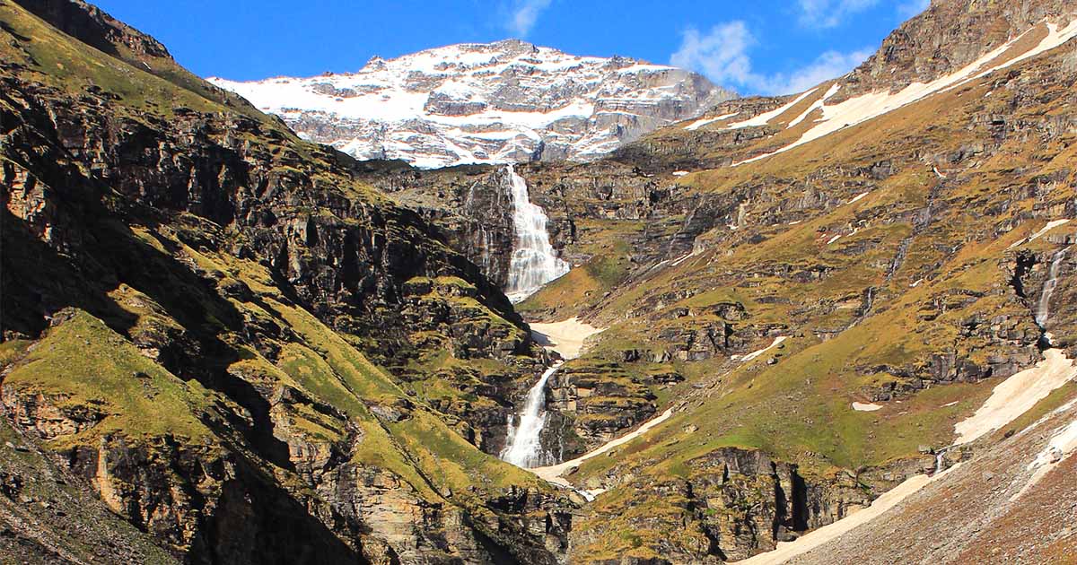
- Dramatic Waterfall Campsite: The main highlight of Rupin Pass trek is a stunning campsite right below the famous Rupin Waterfall. The Rupin Pass is known for its multi-tieing waterfall, means each tier has its own pool at the bottom. Rupin Waterfall makes campsites visually appealing and soul-soothing.
- Beautiful Destinations/Campsites: The beautiful destinations or campsites on Rupin Pass trek includes:
- Dhaula (a starting point in Uttarakhand, known for its culture and beauty)
- Sewa (famous for a unique temple on the border of Himachal and Uttarakhand)
- Jhaka Village (it's also called a 'Hanging village' built on a slope)
- Upper Rupin Valley (filled with alpine meadows and waterfalls)
- Rupin Pass (4,650 m – offers panoramic Himalayan views)
- Sangla Valley (the ending point in Himachal Pradesh, known for apple orchards)
- Flora and Fauna: On the trails of Rupin Pass, there are dense forests of oak, pine, rhododendron and deodar. You will get to see alpine flowers like blue poppies, primulas, Brahma Kamal (rare) at higher altitudes.
For wildlife enthusiasts, there are Himalayan langurs, red foxes, mountain goats, Himalayan monals and musk deer often spotted.
- Culture and Tradition: Rupin Pass presents the blend of Garhwali (Uttarakhand) and Kinnauri (Himachal Pradesh) cultures. Both cultures have their own uniqueness in attires, languages and local festivals. The hospitality of mountain villagers is heart warming and their simple lifestyle wins the heart.
- Cross-State Himalayan Pass: Rupin Pass trek is a cross-state trek. It crosses two states and multiple landscapes. From forests to alpine meadows to waterfalls to snow landscapes, it passes through a dramatic shift. The Rupin Pass trek is not merely a physical adventure, it's an experience of deep nature's and culture's phenomena.
To reach the Rupin Pass trek, first arrive at Dhaula village in Uttarakhand. Dhaula village is the basecamp for Rupin Pass trek. The nearest major city is Dehradun which is well-connected by road, air and train.
You can take a flight to Jolly Grant Airport, Dehradun and from there take a taxi/cab to reach Dhaula which is around 210 km (8-10 hrs) via Purola, Mori, Netwar and Mori.
From Dehradun, drive or take a taxi to Dhaula: Dehradun – Purola – Mori – Netwar – Dhaula
Similarly, you can take a taxi from Dehradun Railway Station and head to Dhaula as mentioned above. Make sure you start early in the day due to remote and patchy connectivity.
Once you reach Dhaula, you can start your trek. The trek begins at Dhaula (1,580 m) in Uttarakhand and ends at Sangla (2,700 m) in Himachal Pradesh.
After crossing the pass, you can travel to Sangla to Shimla by road (7-8 hrs) and then return to Delhi or other cities by train, bus or flight.
Notice: All trekkers are strictly advised not to carry unnecessary plastic items such as disposable bottles, single-use cutlery, polythene bags, and food wrappers during the trek. We encourage the use of reusable bottles, tiffin boxes, and cloth bags to minimise waste and protect the fragile Himalayan ecosystem. Your cooperation is essential in ensuring a clean and sustainable trekking experience
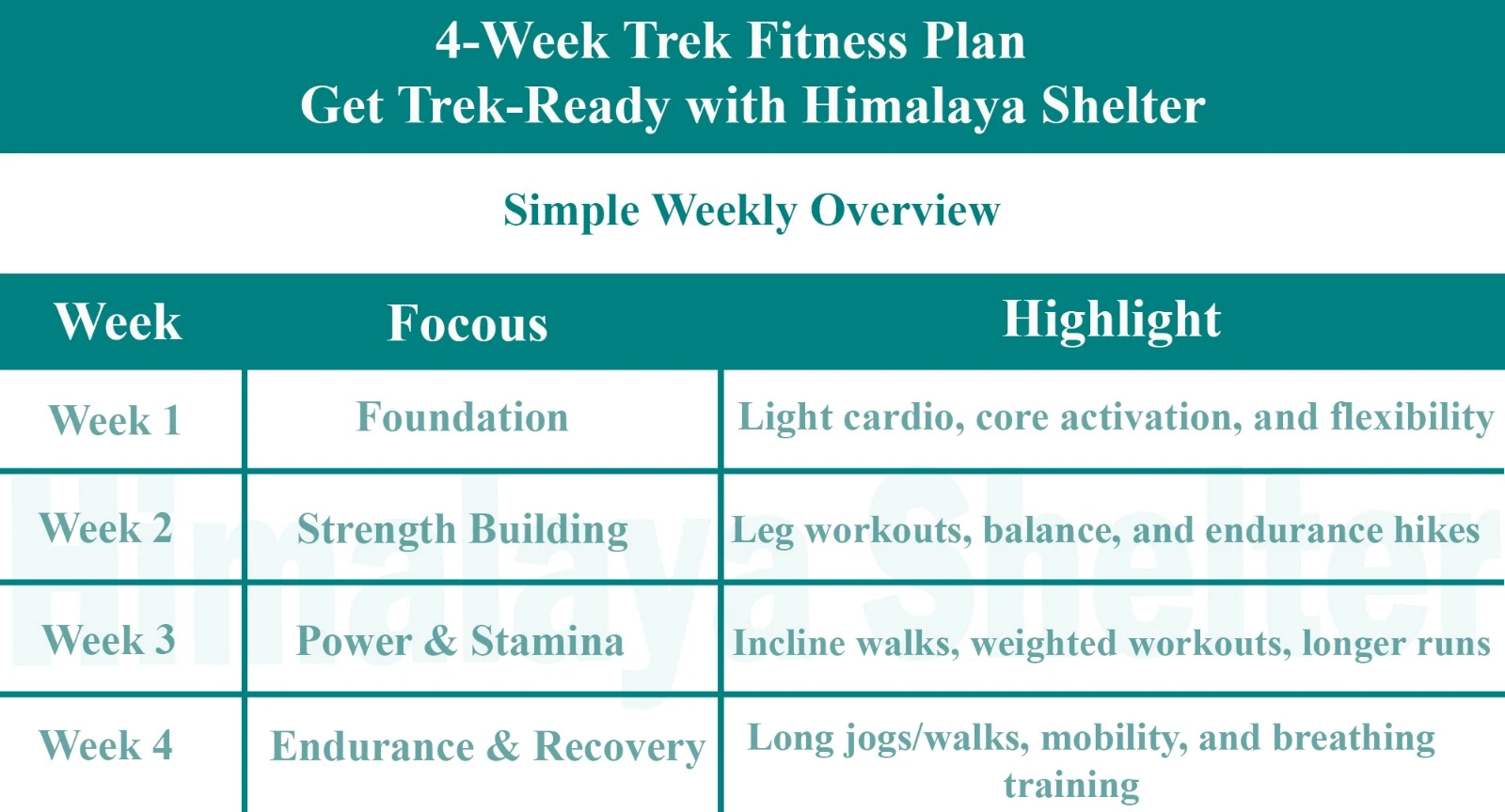
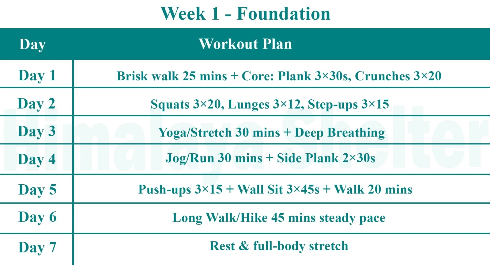
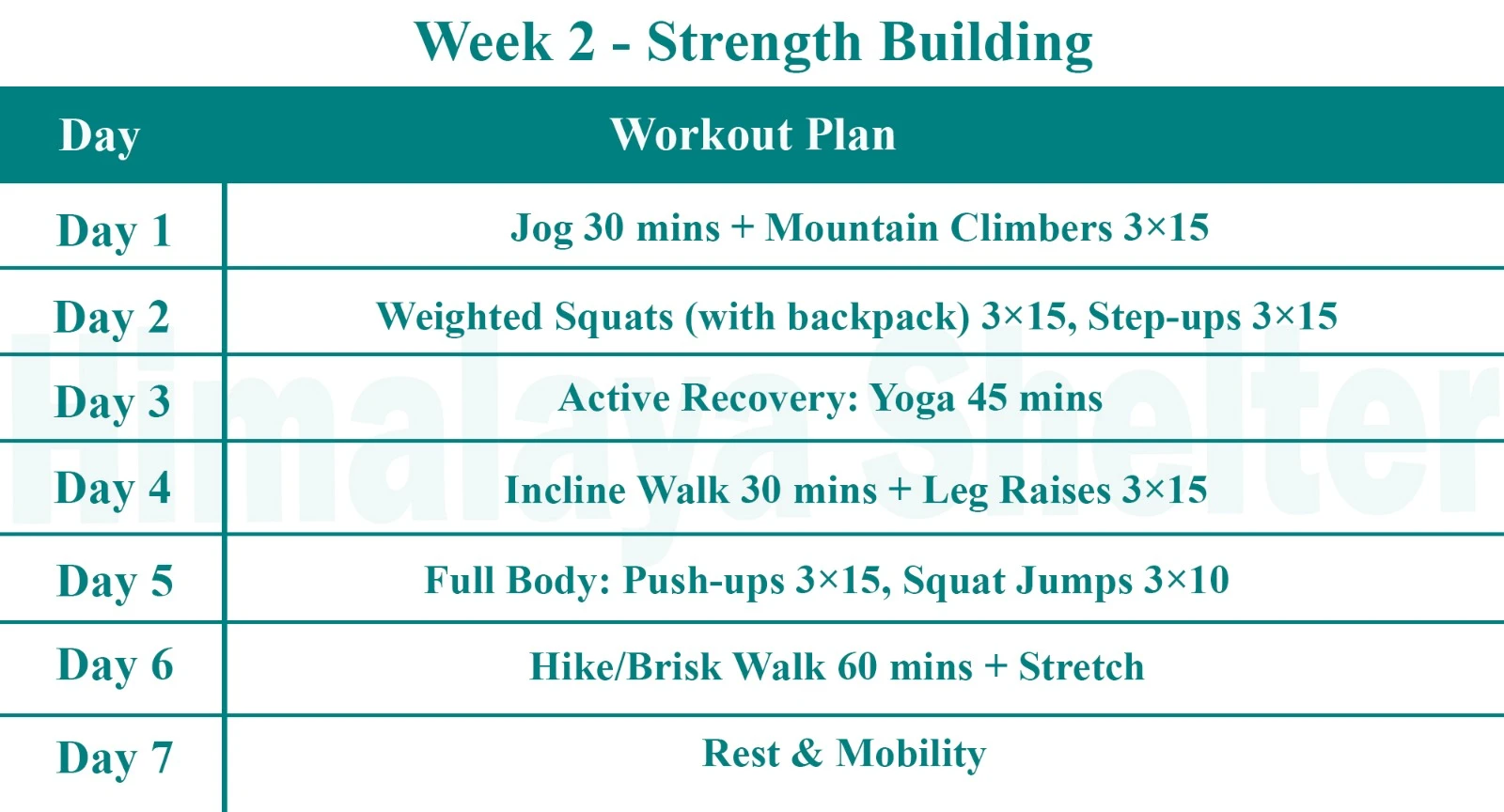
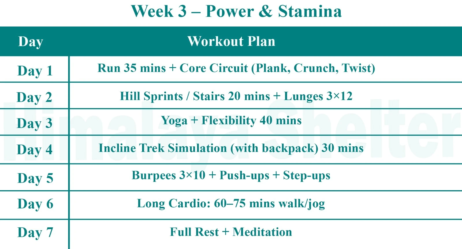
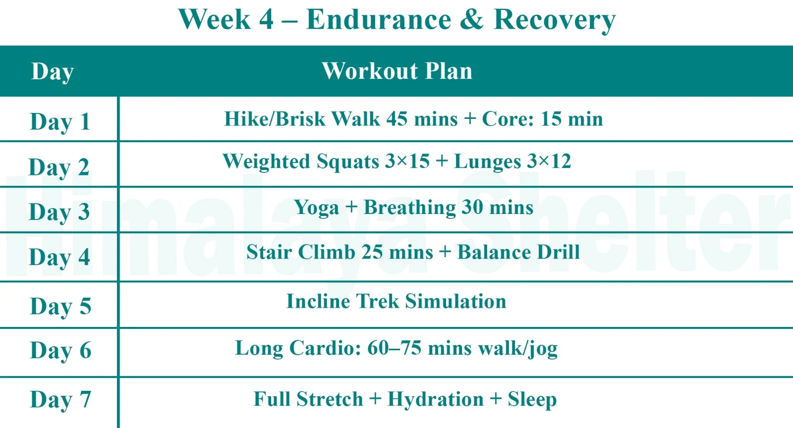
Physical Fitness Preparation for Trek:
To overcome the difficulty level of Bali pass trekking, it requires strong cardiovascular endurance, muscular strength, and overall physical fitness. Incorporate these exercises into your routine to increase strength, stability, and stamina, which will help you tackle difficult terrain sections of the trail at high altitudes.
The best time to trek in Rupin Pass is from May to June and from September to mid-October. These windows offer the most favourable time and stable weather.
- May to June
From May to June, the trails are filled with snow bridges and melting glaciers. Snow adds some adventure but trails can be slushy. However, the meadows are lush green and filled with blooming flowers. The sky is clear and visibility is good. Daytime temperature range goes between 10°C to 15°C while at night time it can dip to 0°C or below, especially on higher camps like Upper Waterfall or Rati Pheri.
- September to mid-October
This time landscapes come alive and fresh with more greenery after monsoon. Trails are dry but at higher altitudes, snow can still be presented. The sky is clearer and mountain peaks are easily visible. Valleys glow with the golden hue of autumn. During this time, daytime temperature remains around 10°C to 12°C and at night time it can go down to 2°C to below 0°C.
Note: Avoid July to August due to heavy rainfall which makes trails slippery and prone to landslides. Similarly winters (November to April) are not suitable due to heavy snowfall and cold temperatures.
The Rupin Pass is considered a moderate to difficult trek. It is located at the altitude of around 4,650 m (15,250 ft) which is suitable for experienced trekkers. The terrain of Rupin Pass is highly diverse. It ranges from dense forests to lush meadows, rocky trails, icy hanging villages, icy slopes and the thrilling Rupin waterfall. Every day, trekkers have to walk through changing landscapes which is adventurous but also challenging.
The total trek duration is around 8 to 9 days which covers approx 52-56 km, depending on the route. Each day involves 5 to 8 hours of walking which can stretch to 10 to 12 hours around the final pass crossing.
Weather conditions can be unpredictable at higher altitudes. Sometimes snowfields are present near the pass even during the summer. Sudden rainfall and hailstorm can add difficulty.
Trekkers need basic technical support while crossing the pass. On snowfields and steepy ridges, usage of rope and ice axes are common. The basic mountaineering skills and technical guidance is required.
Due to high-altitude and technical challenges, Rupin Pass trek is not suitable for kids and families. Beginners can attempt it but they must be physically fit and mentally enduring. Solo trekking is also not advisable due to difficult terrain and safety.
The Rupin Pass trek is ideal for serious mountaineers who are looking for a thrilling journey and high-altitude adventure.
Day 1: Dehradun to Dhaula (1,580 m) drive: 200 KM in 8 hours

The drive from Dehradun to Dhaula passes through the towns of Mussoorie and the villages of Nainbagh, Damta, Naugaon, Purola and Mori. After Mori, it is a beautiful drive along the Rupin River through mixed oak and connifer forests. We reach Dhaula by evening. Overnight in camps.
Day 2: Dhaula (1,580 m) to Sewa (2,000 m) to Aaligad: 14 KM trek in 7 hours

This is the first day of our trek. The trail is on the true right of the valley climbing up gradually. Pisa and Khana villages are seen across the river. We climb up high above the river to Danti Dhar. The path passes through beautiful rhododendron forests. Sewa has a beautiful Hindu temple and lies on the border of the two states. We camp a little after the village on the banks of the river at a site known as Aaligad.
Day 3: Aaligad to Jakha (2,300 m): 9 KM trek in 4 to 5 hours

The trail continues along the true right of the valley. The trail is fairly gradual, going past the two large but remote villages of Dodra and Kuar. This region has recently been connected by road from Rohru (Shimla Region). The road is being extended till Jakha. We cross the bridge below Kuar village and take the path climbing up to the village. This path will join the trail on the true right below Jiskun village. From here the trail steeply climbs to Jiskun, which is located high above the confluence of Rupin and Narkund Khad. Jiskun has a small forest rest house. Continuing along the path, we descend steeply to a side tributary and after a short and steep ascent reach Jakha.
Day 4: Jakha to Burans Kandi (3,080 m): 7 KM trek in 5 to 6 hours

It is a beautiful walk through blue pine and maple forests. After a while the trail starts to descend to the river. There is a small bridge taking the trail to the true left of the valley. We camp overnight beside the river beside a spot frequented by shepherds.
Day 5: Burans Kandi to Lower Waterfall (3,450 m): 6 KM trek in 3 to 4 hours

The forest changes to silver Birch and rhododendron leading to alpine meadows. In season, the area looks spectacular with wild flowers and blue poppies. We walk on the large meadow surrounded by mountains and waterfalls. There is a huge and impressive waterfall in the middle of the valley leading up to the pass.
Day 6: Lower Waterfall to Rupin Pass Basecamp (4,350 m): 6 KM trek in 4 to 5 hours

We start early today to make it to the Base camp of the Rupin pass by afternoon. We start our journey towards the Waterfall and after traversing the steep sections we reach the Upper Waterfall campsite, which is majestic. We spend some time here enjoying the views and have our packed lunch. It seems an ideal campsite but we approach the base camp as it will reduce our ascent to the pass and offer a very different camping experience. The base camp is covered in snow till late June and thus camping in snow from the winters, is a vivid summer experience, with the entire campsite largely to ourselves as we leave most of the groups behind. In the evening we can go climb up the nearby ridges to get panoramic views of the landscape covered in snow.
Day 7: Basecamp (4,350 m) to Rupin Pass (4,690 m) to Ronti Gad (3,990 m): 9 KM trek in 7 to 8 hours

There are excellent views of the hanging glaciers and snow fields on the way to the pass. It is a fairly narrow and steep path through the boulders; in case of snow a rope maybe used. From the pass, one can witness great views of the Kinnaur Kailash range. We descend to the alpine meadows with lots of camping options.
Day 8: Ronti Gad to Kanda to Sangla (2,650 m): 12 KM trek in 5 to 6 hours
Today is a beautiful short trek through blue pine, deodar and oak forest overlooking the Sangla valley. It is a fairly steep descent. Sangla valley is known for growing one of the best quality apples in the world. It is also one of the starting points of the famous Kinnaur Kailash trek. Sangla is connected by road to Shimla. One can get public or private transport from Sangla to Shimla.
Inclusions
Our treks are specially designed by the experienced team at Himalaya Shelter, taking you on an adventure of a lifetime all while making you connect not only with the bountiful nature but also with yourself and with others on the trek with you creating wonderful memories which will last you a lifetime. All Himalaya Shelter treks are guided by experienced Trekkers having vast knowledge and experience of the region, providing with insightful information and stories pertaining to the region’s flora and fauna and the history of the region whilst the trek. It is safe to say that on successfully completing the trek, one will gain tremendous insight and experience along with lifetime memories.
- Transport Support from Dehradun to Dhaula on Day 1
- Accommodation – At Base Camp, stay at a local homestay or guest house for one night each, which will give you an insight into the authentic lifestyle of the locals.( INR 5000 per person extra for single sharing throughout the trek )
On Trek stay in a 2-person Vango Halo Pro/A-Shape tent, which is to be shared by two trekkers, built to withstand extreme weather conditions and at the same time making you comfortable after a hard day’s trek. - Camping Equipment – specially designed sleeping bags that can withstand harsh weather conditions, foam mattresses. Other safety gear like microspikes, gaiters, an ice axe, and helmets will be provided.
- Medical Kit – our team will be equipped with an extensive medical kit, which our team is trained and experienced to use. Oxygen cylinders are used after they are thoroughly inspected throughout the Trek. Even campsites have large oxygen cylinders as backups.
- Permission - Forest entry charges for Indian nationals (Additional charges will be applicable for international tourists)
Meals – Breakfast, packed lunch (on trek days), evening snacks, and dinner will be served. A hearty, delicious, and nutrition-filled Veg meals with egg preparation will be provided throughout the trek. (Jain and Vegan Food can also be arranged on prior notification.)There will be a dedicated Kitchen Tent along with a dining tent, which will have a dining table too. - Our Team – A highly experienced and AMC-certified Trek Leader who will help ensure that the entire trek goes smoothly and safely while navigating the challenging conditions during the trek, and is skilled enough to navigate any medical emergency that can arise during the trek. Local and route Guides who are well-versed with the region and provide an in-depth insight into the local customs and knowledge of the flora and fauna endemic to the region. A dedicated Kitchen staff, which includes a Cook, a helper, and other support staff. There will also be porters and mules to carry common equipment.
- Cloakroom - We have a cloakroom facility available for extra luggage. Every trekker is permitted to leave their luggage behind at no charge.
Exclusions
- Personal expenses like tips, personal medicines, phone calls etc.
- Travel Expenses - Travel expenses from your hometown to the mentioned Pick-Up Point are not included in the trek fee.
From the scheduled pick-up spot to the base camp, we have our own fleet of vehicles like Bolero, Innova, Dezire, or Tempo Traveler (12-seater). This is be shared by trekkers for a pre-decided amount. All vehicles are non-AC. - Personal Equipment - Any personal gear like jackets, shoes, cutlery, or backpacks are not included in the trek fee. We recommend renting them from our Rental Store for an affordable fee. This can be pre-arranged to avoid last-minute hang-ups.
- Offloading - We encourage carrying your backpack to get into the true spirit of trekking. However, if needed, you can opt to offload your personal luggage of up to 12 kgs for an additional cost of INR 500 per bag per day.
- Trek Insurance - A mandatory trek insurance fee is charged in addition to your trek fee. Since most medical insurance doesn’t cover adventure activities, trek insurance offers essential coverage, enhancing your safety without a significant financial burden.
- Buffer day on the trek - We have kept a buffer day on the trek to account for any weather-related delay. If this is utilized, you will need to pay an extra amount to your trek leader.
- Anything apart from inclusions
- Please carry a lunch box for a packed lunch/breakfast to avoid using polythene and Aluminium foil.
Keeping the Himalayas clean is our own responsibility. Reduce the use of Plastic when you are in the abode of the Sacred Himalaya. 🌱
The Rupin Pass Trek is a grand trek across the heights of the Himalayas that begins in Uttarakhand and ends in Himachal Pradesh.
The Rupin Pass is located in the Govind Pashu Vihar area of Uttarakhand, near the border between Himachal Pradesh and Uttarakhand, and connects the Tons Valley and Kinnaur.
The highest point on the Rupin Pass trek is about 15,250 feet (4,650 meters).
The Rupin Pass trek is rated as moderately difficult to difficult due to the steep ascents, long days of hiking, trekking across snow, and altitude challenges involved in completing this trek.
The distance of the trek from Uttarakhand to Himachal Pradesh is about 40–45 kilometres, and most itineraries require between 7 and 8 days.
The best months for the Rupin Pass trek are May through June, and September through October, as these times offer stable weather and clearer views.
Rupin Pass is not recommended for beginners.
Read More on Rupin Pass Trek
Photo Gallery


Treks by Categories
Treks By Month

Treks By Experience

