Trek Fee
₹ 105000$ 1210+ 5% GST | + Rs 180 Trek Insurance |
View Dates & Register |
Trek Fee
₹ 105000$ 1210+ 5% GST | + Rs 180 Trek Insurance |
View Dates & Register |


|
TREK DIFFICULTY Easy |
|
TREK DURATION 13 days |
|
|
HIGHEST ALTITUDE 17260 Feet | |
GROUP SIZE 12 People | |
|
TOTAL TREK DISTANCE 80 Km | |
BASECAMP Uttarakhand | |
|
BEST TIME May to June and September to Early October | |
PICKUP POINT Dehradun (Prince Chowk) |

Days 1–4: Approach & Acclimatization
Day 1: Dehradun → Joshimath (by road; overnight hotel stay)
Day 2: Joshimath → Badrinath → Shepherd Camp
Day 3: Shepherd Camp
Day 4: Shepherd → Snout Camp
Days 5–8: Glacier Traverse & Summit Push
Day 5: Snout → Moraine Camp (4,300 m)
Day 6: Accommodation & Rest at Moraine Camp
Day 7: Moraine Camp → Parvati Col Base
Day 8: Base → Panpatia Snowfield Camp (5,150 m)
Days 9–13: Summit, Descent & Departure
Day 9: Snowfield Camp → Panpatia Col (5,260 m) → Sujal Sarovar (4,750 m)
Day 10: Sujal Sarovar → Kachni (4,159 m)
Day 11: Kachni → Nanu Chatti (3,250 m)
Day 12: Nanu Chatti → Ransi → Rudraprayag
Day 13: Rudraprayag → Dehradun
In Himalaya Shelter, we provide you with the option to customize your Panpatia Col trek experience. Whether you're an avid mountaineer, an adventure seeker or a group of friends, you can opt for our personalized tailor-made expedition program. This customized program will be exclusively designed for you, taking into account your specific requirements for transportation, accommodation, meals, technical equipment and any other premium facilities you may need during the climb.
Starting from Dehradun (pick up point), the Panpatia Col trek passes through scenic destinations and reaches Joshimath and then Badrinath. From here, you start your actual expedition.
Himalaya Shelter ensures your journey is safe and memorable with experienced local guides, technical support and all necessary permits. You can even request offbeat routes or sunrise hikes for a more immersive Himalayan experience.
Moreover, no other participants will be added to your group. Choosing a customized program will enable you to enjoy your journey without any hesitation.
Our treks are specially designed by the experienced team at Himalaya Shelter, taking you on an adventure of a lifetime all while making you connect not only with the bountiful nature but also with yourself and with others on the trek with you creating wonderful memories which will last you a lifetime. All Himalaya Shelter treks are guided by experienced Trekkers having vast knowledge and experience of the region, providing with insightful information and stories pertaining to the region’s flora and fauna and the history of the region whilst the trek. It is safe to say that on successfully completing the trek, one will gain tremendous insight and experience along with lifetime memories.
Trek Inclusions
Trek Exclusions
Please carry a lunch box for a packed lunch/breakfast to avoid using polythene and Aluminium foil.
Keeping the Himalayas clean is our own responsibility. Reduce the use of Plastic when you are in the abode of the Sacred Himalaya. 🌱
The Panpatia Col Trek has an 8/8 difficulty rating making it a very challenging trek. This trek is extremely difficult and requires a high level of endurance stamina and physical fitness. It is highly necessary for trekkers to have prior trekking experience in an area with high elevations of 4500–5000 feet.
Each persons average cost for this trek ranges from Rs 90000 to Rs 175000. The size of the group the services needed and the trekking teams and guides experience all affect the price. For overseas trekkers the price will be greater.
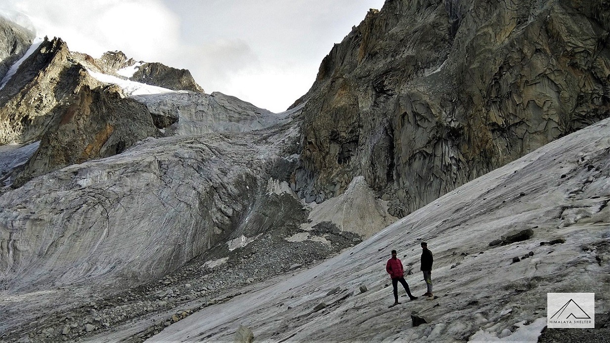
One of the hardest and most difficult treks in the Garhwal Himalayas is the Panpatia Col trek which connects the sacred pilgrimage sites of Kedarnath and Badrinath. At an astounding 5260 meters (17260 feet) above sea level this high altitude pass is situated between two unnamed peaks that are more than 5500 meters high. h. Situated between two unnamed peaks that are more than 5500 meters high this high altitude pass is an astounding 5260 meters (17260 feet) above sea level.
The Panpatia Col Trek stands out for linking Badrinath and Kedarnath, two foremost shrines of the Hindu religion, through a historic glacier pathway. It is equally renowned for its Koukhamba, Nilkanth and Parvati peaks as well as the Upon of Heaven myth encircling the course.
If feeling fortunate, wildlife enthusiasts can spot the snow leopard, the Himalayan blue sheep, and musk deer. Closer to the base, there are forests of rhododendron, while alpine meadows and glacier landscapes dominate the higher altitudes.
May–June and September–early October.
Yes, with proper permissions and gear.
Yes, Madmaheshwar Temple and Panpatia Glacier are spiritually significant.
Forests, boulder fields, glaciers, snow slopes and steep ridges.
Nights can go as low as -5°C to -10°C.
No, it’s only for seasoned trekkers.
It's believed to be the mythical route walked by the Pandavas from Kedarnath to Badrinath.
Glaciers of Uttarakhand:
Top Winter Treks in Uttarakhand:
Uttarakhand: Your all year adventure destination:
Passes of Uttarakhand:
Your All Year Adventure In Uttarakhand:
10 Most Difficult Treks In India: Gems For Seasoned Trekkers
Top 25 Treks In Uttarakhand Starting From Dehradun:
Himalaya Shelter