Altitude: 2,100 ft (640 m) – 6,430 ft (1,960 m)
Accommodation: Guest House / Homestay / Hotel
Meals: Dinner
Drive: 52 km, 2 hrs
Altitude: 6,430 ft (1,960 m) – 10,000 ft (3048 m)
Accommodation: Guest House / Homestay / Hotel
Meals: Breakfast + Lunch + Evening Snacks + Dinner
Trek: 14 km, 6-7 hrs
Altitude: 10,000 ft (3048 m) – 12,467 ft (3,800 m)
Accommodation: Camping (Alpine Tents)
Meals: Breakfast + Lunch + Evening Snacks + Dinner
Trek: 13 km, 6-7 hrs
Altitude: 12,467 ft (3,800 m) – 12,795 ft (3,900 m) – 14,640 ft (4,462 m)
Accommodation: Camping (Alpine Tents)
Meals: Breakfast + Lunch + Evening Snacks + Dinner
Trek: NA
Altitude: 14,640 ft (4,462 m)
Accommodation: Camping (Alpine Tents)
Meals: Breakfast + Lunch + Evening Snacks + Dinner
This day is free for us to acclimatize, relax and enjoy the magnificent snow-capped peaks, flora, fauna, and mountain landscape. This land is frequented by some of the greatest contemporary mountaineers. The Shivling peak stands tall in front of us. Behind Shivling, towards the right is Meru. A little towards the left of Shivling, is Sumeru. The Bhagirathi peaks are visible further to the left. Bhagirathi III, Meru (Central Peak) and Sumeru have some of the hardest climbing routes in the world. We can visit the Meru Glacier and return to our campsite.
Trek: 8 km, 6 hrs
Altitude: 14,640 ft (4,462 m) – 15,780 ft (4,810 m)
Accommodation: Camping (Alpine Tents)
Meals: Breakfast + Lunch + Evening Snacks + Dinner
On this day, post-breakfast, our trek begins with a descent onto the glacier. The glacier, nestled between two ranges, often features a layer of rocky moraine due to landslides, facilitating somewhat easier walking conditions. However, staying together as a group is crucial on the glacier, as veering off the trail is common. Keeping a watchful eye on cairns, or stacked rocks, helps maintain the right path.
Walking on the glacier demands caution due to its slippery surface. Even a momentary lapse in focus can pose risks, given the presence of large crevasses scattered throughout. After covering about a kilometer, the trail ascends vertically, navigating through substantial boulders alongside. Dinner and overnight camping await us at the Nandanvan campsite.
Trek: 6 km, 4-5 hrs
Altitude: 15,780 ft (4,810 m) – 15,748 ft ft (4,800 m)
Accommodation: Camping (Alpine Tents)
Meals: Breakfast + Lunch + Evening Snacks + Dinner
Trek: 6 km, 5-6 hrs
Altitude: 15,748 ft ft (4,800 m) – 17,060 ft (5,200 m)
Accommodation: Camping (Alpine Tents)
Meals: Breakfast + Lunch + Evening Snacks + Dinner
Trek: 8 km, 5-6 hrs
Altitude: 17,060 ft (5,200 m) – 17,880 ft (5,500 m)
Accommodation: Camping (Alpine Tents)
Meals: Breakfast + Lunch + Evening Snacks + Dinner
After breakfast, our trek continues towards Sweta Glacier, reaching an altitude of 5,500 meters. This leg of the journey is relatively shorter in duration, leading us to a campsite nestled in the moraine, characterized by an expanse filled with rocks and boulders.
Trek: 6 km, 4-5 hrs
Altitude: 17,880 ft (5,500 m) – 18,372 ft (5,600 m)
Accommodation: Camping (Alpine Tents)
Meals: Breakfast + Lunch + Evening Snacks + Dinner
Trek: 13 km, 8-9 hrs
Altitude: 18,372 ft (5,600 m) – 19,500 ft (4,945 m) – 16,076 ft (4,900 m)
Accommodation: Camping (Alpine Tents)
Meals: Breakfast + Lunch + Evening Snacks + Dinner
On this day, our trek spans a distance of 12 kilometers towards Kalindi Pass, standing at an elevation of 5947 meters. Upon reaching this breathtaking spot, we’ll indulge in some time to absorb the beauty before descending to camp at Rajparav.
The ascent to the pass is undoubtedly challenging, demanding a consistent and steady pace until we reach our destination. However, the moment you stand atop the pass, the realization dawns that every ounce of effort was truly worthwhile. The panoramic vistas of Mt. Kamet, Mt. Mana, Chandra Parbat, Vasuki Parbat, and, on clear days, even glimpses of the Tibetan Plateau, unfold before you, offering an awe-inspiring reward for your toil and determination.
Trek: 13 km, 6-7 hrs
Altitude: 16,076 ft (4,900 m) – 12,830 ft (3,910 m)
Accommodation: Camping (Alpine Tents)
Meals: Breakfast + Lunch + Evening Snacks + Dinner
We commence the trek early in the morning, heading towards Arwatal at an altitude of 3,910 meters. The journey encompasses a lengthy traverse across glacier terrain, ultimately leading us to the stunning Arwa Tal.
Trek: 7 km, 4-5 hrs
Altitude: 12,830 ft (3,910 m) – 12,435 ft (3,790 m)
Accommodation: Camping (Alpine Tents)
Meals: Breakfast + Lunch + Evening Snacks + Dinner
We set out early for a 16-kilometer trek to Ghastoli (3796 m), departing from Arwatal. The journey entails a considerable walk across moraines, showcasing a striking transition in the terrain from stark grey to lush greenery as we approach Ghastoli. This location is a breathtaking meadow, a visual delight, offering a serene and picturesque respite along the trek.
Trek: 6 km, 3 hrs
Drive: 10 km, 30 min
Altitude: 12,435 ft (3,790 m) – 10,500 ft (3,200 m) – 10,826 ft (3,300 m)
Accommodation: Camping (Alpine Tents)
Meals: Breakfast + Lunch + Evening Snacks + Dinner
Drive: 327 km, 8-9 hrs
Altitude: 10,826 ft (3,300 m) – 2,100 ft (640 m)
Accommodation: Camping (Alpine Tents)
Meals: Breakfast + Lunch + Evening Snacks + Dinner
After breakfast, we’ll embark on a drive to Dehradun. The journey traces along the Alaknanda River until we reach Devprayag, where it merges with the Ganges.
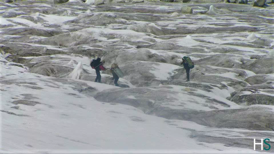
Crossing the Glacier with Crevasses; The most chalenging part of the trek
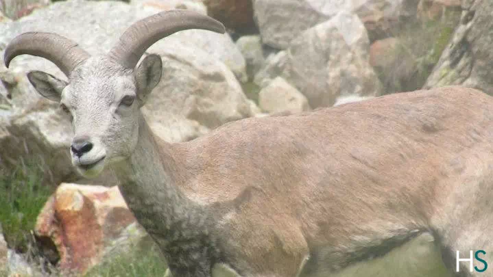 Himalayan Ibex
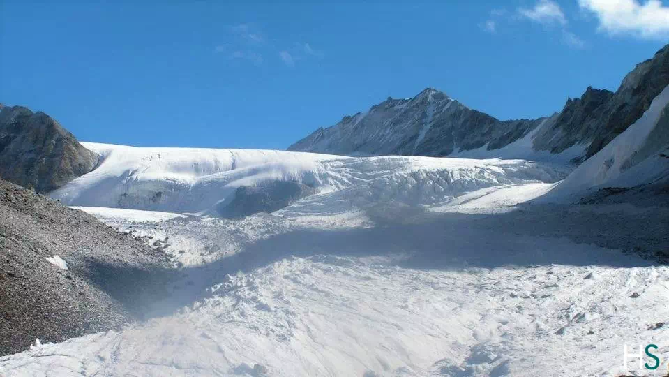
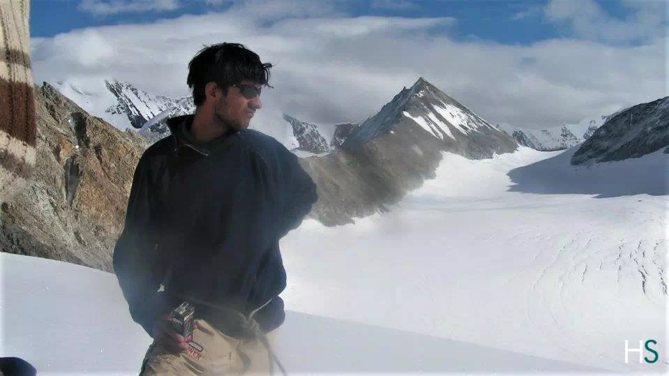 Feeling of being on the top of the world; Glacier appering in the background
 Climbing through moraines can be really tricky and demands complete attention.
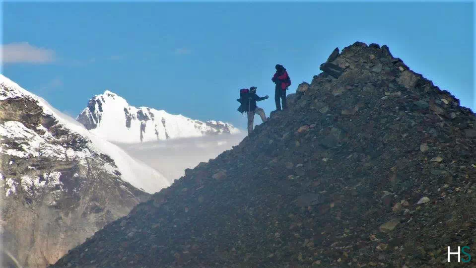
 Team of experienced trekkers getting ready to walk through the high altitude snow covered mountain terrain
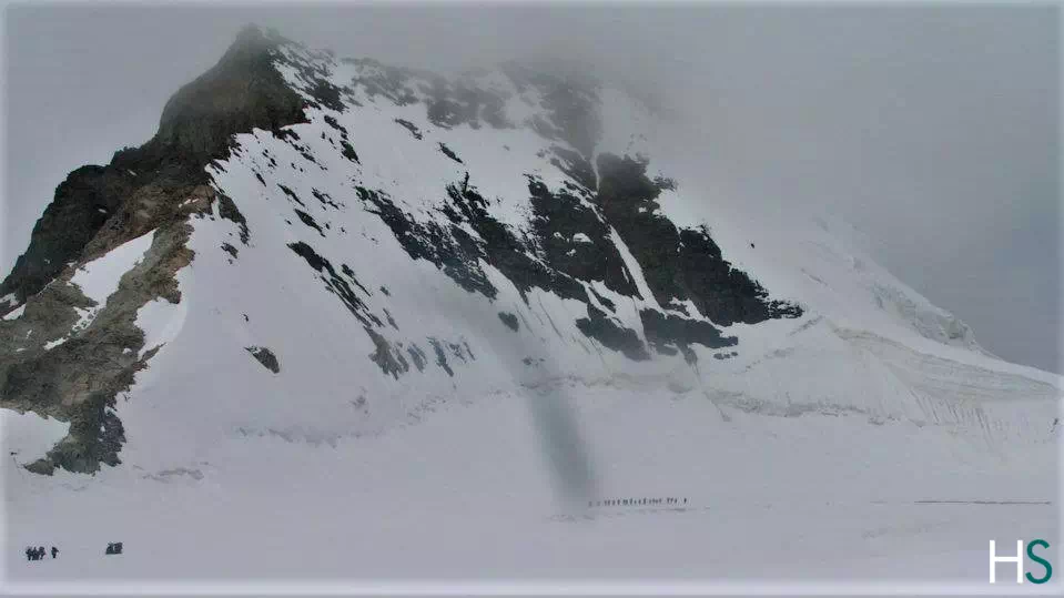 During the Kalindi Khal Trek, one encounters with many Glaciers like, Gaumukh Glacier, Sweta Glacier and Kirti Glacier
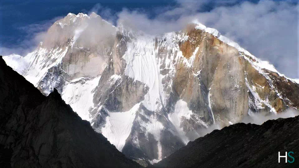
 Spectacular mountain views en route Kalindi Khal Trek
Mesmerising beauty of Himalayas
Spectacular mountain views en route Kalindi Khal Trek
Mesmerising beauty of Himalayas
The Kalindi Khal trek is a challenging high altitude trek in the Indian Himalayas known for its beauty and challenging terrain.
This trek is in the Indian state of Uttarakhand, specifically in the Garhwal Himalayas. It starts from Gangotri and ends at Badrinath.
It usually takes about 14 to 15 days to complete, covering about 122 kilometers (75 miles).
The best time to start trekking Kalindi is during the summer months, from May to June, and then back again in September. During these times, the weather tends to be stable and the roads less frequent.
The Kalindi River trek is considered very challenging and suitable only for moderately experienced trekkers. The route involves climbing and descending, crossing ice and crossing challenging terrain.
Essentials include sturdy walking shoes, warm clothing, waterproof gear, sleeping bags, walking sticks, high-fiber foods, first aid and a water purification system for the surrounding areas.
Yes, a permit is required to visit Kalindi Falls, as it passes through protected areas. These permits can be obtained from the Forest Service or from authorized leasing agencies.
Although experienced hikers can try the walk on their own, hiring a local guide is highly recommended for safety reasons. Guides know the terrain and weather and can provide valuable assistance in an emergency.
This trek offers breathtaking views of several Himalayan peaks like Shivling, Bhagirathi and Meru. This includes crossing the famous Kalindi Canal Pass at an altitude of over 5946 meters (19,511 feet), making it a truly unforgettable experience for adventurers
Yes, mountain sickness can be a concern because of the high altitudes encountered while hiking. When symptoms of altitude sickness such as headaches, nausea and dizziness occur, it is important to be in good shape, stay hydrated and get off.
Reviews
There are no reviews yet.