Chandratal Baralacha Trek

Chandratal Baralacha Trek

A spectacular route, as offbeat as it can get in the heart of the Great Himalayan range

Duration
7 Days
Trek Altitude
16,140 Feet
Destination
Himachal
Trek Distance
40 or 52 KM
Group Size
12
Best Time
June to September

Chandratal Baralacha Trek

The Chandratal Baralacha La ('la' means pass) is a popular pass crossing that lies at the intersection of the Great Himalayan range and the Zanskar range of mountains, within the ambit of the Himalayas, in Lahaul, Himachal. The pass connects the popular destination of Ladakh with Manali, one of the most popular Indian hill stations. Chandratal Baralacha Trek is a lake that is situated along the eastward route to Spiti (from Manali), along one of the most treacherous roads in the world. The lake became a popular attraction among trekkers completing the Hampta Pass trek. Few, however, have heard of the Chandratal to Baralachala trek route, and rarely does anyone even attempt it.

The trek starts in the middle of nowhere and ends at one of the most difficult pass crossings along an already desolate road. This makes it a nightmare for any alpine style trekkers, as prior planning and logistical support are of utmost importance.

Chandratal Baralacha La Trek route

The trek starts after a drive to the Chandratal lake. Nowadays the drive is much easier owing to the opening of Rohtang tunnel, and thus we avert the Rohtang pass crossing. Proper acclimatization is needed as the Chandratal has an altitude of 13,940 feet/ 4,250 meters.

The trek can even be started from Kunzum La. 

It takes 4 trekking days from Kunzum La to reach Baralacha La, with average trek of more than 12 KM everyday.

Why should you do the Chandratal Baralacha La trek?

The trek covers some of the most remote areas that you can come across in the Indian Himalayas. The topography is very unique and is nestled between two prominent ranges of the Himalayas, namely the Great Himalayan range and the Zanskar range. There is no trace of any form of civilization along the route and your only companions will be the Gaddi shepherds that wander these lands. If ever peace could be found in the vast swathes of wilderness, you are surely going to find it on this trail.

Interestingly, the trek can be combined with the popular Hampta Pass trek, which starts very close to Manali, to make one spectacular journey, with tales for a lifetime. Further, the acclimatization as a result of the Hampta Pass trek saves time that otherwise would be spent leisurely acclimatizing for the Chandratal to Baralacha La trek.

You can combine it with more treks and make your way all the way up to Zanskar, the heart of Ladakh.

Regardless in itself the trek is a great add on if you are traveling to Leh and will provide a vivid experience as you cross two prominent passes (3 if Hampta pass is added to the itinerary).

Hampta pass with Chandratal Baralacha La trek

Here we share a brief itinerary to guide you for the longer trekking route. You can check out the standard itinerary for the Chandratal Baralacha trek further below -

Itinerary

Day 1: Drive from Manali to Jobra, trek to Cheeka

Day 2: Trek from Cheeka to Balu Ka Ghera

Day 3: Trek from Balu Ka Ghera to Shea Goru via Hampta Pass

Day 4: Shea Goru to Chattru trek, drive to Chandratal

Day 5: Rest day at Chandratal/buffer day

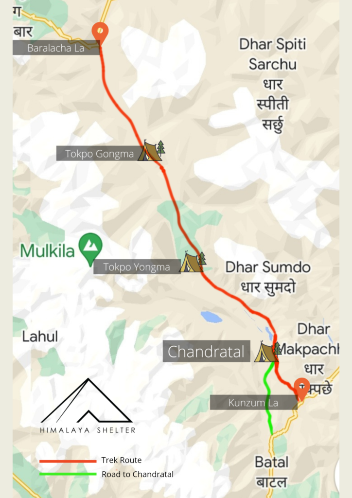
Day 6: Chandratal to Tokpo Gongma trek

Day 7: Tokpo Gongma to Tokpo Yongma trek

Day 8: Tokpo Yongma to Baralacha La trek, drive to Manali/Pang (if headed to Leh)

If rest days are excluded, the trek can be managed in a mere 1 week time period from Manali. It offers a lot of thrill for such a short period. We can curate this itinerary for a wholesome experience for a private group.

What is the best time for the Chandratal to Baralacha La trek?

The trek opening often used to coincide with the opening of the Manali-Leh highway & the road to Spiti from Manali. Nowadays, the road opens well early, sometimes by April itself. The ideal time for the trek is June mid to late-September.

There are two river crossings along the trail, which require careful planning but can be managed despite the rainy season. The weather will generally stay dry in the Lahaul area but short recurrent showers are to be expected.

The route to Manali can be challenging and 1 buffer day needs to be kept for any roadblocks. The bad stretches of roads are now mostly improved with the opening of 2 tunnels (as of August 2022) and another 3 soon to be opened for all-weather connectivity.

Chandratal Baralachala Trek Route Map

Chandratal Baralachala Trek Map  

Chandratal Baralacha La Trek Itinerary

  • Distance: 530 KM
  • Time: 12 hours
  • Altitude: 6,400 feet | 2,050 meters

Volvo buses of Himachal State Transport Corporation and various private buses ply overnight for the journey to Manali, via Chandigarh, Bilaspur, Mandi and Kullu.

Private taxi can be availed for the journey too.

  • Altitude: 6,400 feet | 2,050 meters
  • Type of Accommodation: Guest House/Hotel
  • Attractions: Vashishth waterfall, Hadimba temple, Beas river with riverside restaurants, Mall road etc

The day can be leisurely spent exploring Manali town and nearby attractions. You can even indulge in zipline and rafting.

  • Distance: 95 KM
  • Time: 3 hours
  • Altitude: 12,960 feet or 3,950 meters

The drive is short owing to the construction of the 9 KM long Rohtang tunnel (Atal tunnel) under the Rohtang pass.

After crossing the tunnel the landscape changes dramatically as we enter the arid Lahaul. The drive is alongside the Chenab river, which eventually flows into Pakistan via Kashmir.

  • Distance: 14 KM (to Kunzum La) + 22 KM (Kunzum La to Chandratal)
  • Trek Distance: 12 KM (optional hike from Kunzum La to Chandratal)
  • Time: 2.5 hours
  • Altitude: 13,940 feet | 4,250 meters

After an initial drive to Kunzum La (4,551 meters or 14,931 feet), we head back along the same route for a short distance and then head to Chandratal lake. We camp a KM before the Chandratal lake and hike to the lake in the evening for acclimatization.

If you are up for the challenge we can hike all the way from Kunzum La pass to the Chandratal lake in around 5 to 6 hours covering over 12 KM of distance.

  • Distance: 14 KM
  • Time: 8 hours
  • Altitude: 14,430 feet | 4,400 meters

The trail from Chandratal continues northwards on the true left of the Chandra river (river will be to our left hand side). The trail mostly stays high above the river with views of the valley extending as far as the eyes can see.

At places the trail is non existent and boulder or scree zones dot the terrain. We continue in the northward direction straight ahead.

There are several campsites on the way, where we cross small stream intersections. Often lush pastures can be found here with Gaddi (nomadic shepherds) with their flock of sheep camping in these spots.

  • Distance: 14 KM
  • Time: 8 hours
  • Altitude: 15,255 feet | 4,650 meters

We cross a major stream that runs into the main Chenab river 30 mins ahead of our campsite. From there the trail continues up into the alpine meadows dotted with a variety of flora.

We cross another medium grade stream before reaching our campsite.

We stop short of a major river crossing and camp at a beautiful campsite, at a place known as Tokpo Yongma.

  • Distance: 12 KM
  • Time: 8 hours
  • Drive Time: 5 hours drive – 144 KM to Manali or – 110 KM to Pang (similar time)
  • Altitude: 16,140 feet | 4,920 meters

Early morning we start the day by crossing a major river. In pre monsoon months of June or till mid July, snow bridges are an easy find to cross the river. By August & September we need to get our boots wet to cross the river at a certain wider section with minimal depth.

The trek has several water crossings and after we are done with them all, one is surely going to end up as an expert on crossing mountain streams.

Ethereal beauty welcomes us as we approach the last leg of the trek to the Baralacha La pass.
We hop into vehicles waiting for us and continue our journey either to Manali or Leh depending on what your next destination is.

FAQ's about Chandratal Baralacha La trek

Network connectivity is sparse. We will loose network connectivity after we proceed to Batal. During the trek there is no network connectivity. During return from Baralacha La the network reception is available from Jispa (towards Manali) & Sarchu (towards Leh). Airtel, BSNL & Jio networks are available.

We will have electricity in Batal in camp to charge phones etc, but no electricity during the trek. Carry additional power banks for phone/camera batteries

Apart from the 3 river crossings (and many minor streams) during the trek, the trail is very safe. Even the river crossings can be managed with ease if an experienced trek leader accompanies you. It is not recommended to trek by yourself along this trail without professional guidance.

The area is remote but the villages on the Manali Leh highway are very safe and the locals are very hospitable. Even the travelers driving to Leh via road bond well with each other in such a desolate and remote area, always willing to help each other if stranded.

Reviews

Trek Inclusions
  1. Transfer from Manali to Batal, further Kuzum La/Chandratal & return to Manali from Baralacha La in Cab
  2. Overnight stay in Manali in a cozy guest house for 1 Night before trek start
  3. Stay in Batal in swiss camps
  4. Accommodation during trek in spacious EU standards certified tents for 3 nights with proper camping amenities
  5. All meals from Day 2 Breakfast to Day 7 Lunch
  6. Trained and certified trek leader, cook & support staff
  7. Safety gear where needed
  8. A guaranteed wow experience! We are rated 4.9 based on over 600 TripAdvisor reviews
Trek Exclusions/Add-Ons
  1. Transfers to Manali from Delhi and return (or onward journey to Leh) - can be arranged at an additional cost depending on mode of transport (bus/private cab)
  2. Trek Insurance
  3. Any costs due to delays due to roadblocks or medical evacuation (we have an impeccable safety record in conducting our treks)